We Recommend:
Bach Steel - Experts at historic truss bridge restoration.
Evergreen Point Floating Bridge
Governor Albert D. Rosellini Bridge / SR-520 Bridge

Primary Photographer(s): Nathan Holth
Bridge Documented: August 26, 2014
Seattle and Medina: King County, Washington: United States
Pre-Stressed Concrete Pontoon, Movable: Retractile and Approach Spans: Metal 8 Panel Rivet-Connected Polygonal Warren Through Truss, Fixed
1963 By Builder/Contractor: Guy F. Atkinson and Engineer/Design: Charles E. Andrew
Not Available or Not Applicable
7,518.4 Feet (2291.6 Meters)
12,383.0 Feet (3774.3 Meters)
51.8 Feet (15.79 Meters)
1 Main Span(s)
0006486A0000000

View Information About HSR Ratings
Bridge Documentation
This bridge no longer exists!
Bridge Status: This historic bridge has been demolished and replaced!View Archived National Bridge Inventory Report - Has Additional Details and Evaluation
View Historic American Engineering Record (HAER) Documentation For This Bridge
HAER Data Pages, PDF
View Historic Structure Reports For This Bridge
This historic bridge is being replaced and will be demolished!
Washington State is noted for its several noteworthy "floating bridges." These are not the fragile mid 19th Century wooden pontoon bridges commonly associated with early movable bridge development in cities like Chicago. Unlike any other bridges in North America, Washington State's floating pontoon type bridges include massive heavy-duty floating spans. They were constructed instead of traditional bridge types because of the unusual mud conditions found in the waters they cross.
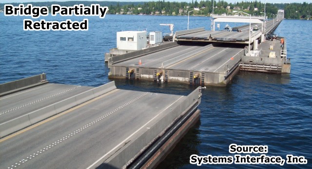
The Evergreen Point Bridge is one of the floating bridges, and it holds the record for the longest floating bridge in the world. It consists of traditional fixed spans at each end. At each end, the approach system includes a ramp system that carries the roadway up to a single span high level through truss to allow for medium sized boats. The through truss spans follow a standard design for mid-20th Century truss spans in Washington State. After the truss spans, the roadway slowly descends down toward the center of the bridge where the floating spans are located. It makes for an unusual looking bridge where the center of the bridge has the lowest elevation. The bridge's floating spans are composed of reinforced pre-stressed concrete cellular pontoon spans that are anchored in place. To add to the unusual design, the very center of the bridge includes a movable span to admit boats that cannot fit under the fixed truss spans. The movable span is just as unusual as the rest of the bridge. It is a combination of vertical lift and rare retractile types of movable bridge. To open the bridge, the span adjacent to a retractile span is raised vertically by 7 feet 2 inches. This allows for the retractile span to roll backward under the raised span.
The National Bridge Inventory lists the span length as 7,518.4 feet because as a floating bridge, that is literally the distance between piers. However there are 33 "standard" and "special" floating sections on the pontoon portion of the bridge and 62 anchors. The two retractile spans are 164 feet long and can provide a 200 foot channel opening. At this point, the lake is 200 feet deep. The total bridge length given by HistoricBridges.org includes the fixed approach spans, is an estimate, and is from Foster Island to Medina.
This bridge and other floating bridges in Washington State have proved troublesome, particularly because they are vulnerable to wind and can be damaged during wind storms. Despite these troubles, even today engineers are unable to find a better alternative to cross this lake, and as such a new pontoon bridge is being built to replace the historic bridge. It would be nice to see some portion of the original historic bridge preserved, however it is not apparent that this is the case. It would be nice to see one of the pontoons preserved. It could be preserved in the water, or even placed on land as an interactive exhibit. The later might be of particular interest because to casual viewers, the pontoon spans just look like a concrete causeway on the water.
Be sure to view the HAER documentation and the Historic Structure Reports for this bridge as they offer a more in-depth discussion.
![]()
Photo Galleries and Videos: Evergreen Point Floating Bridge
Bridge Photo-Documentation
Original / Full Size PhotosA collection of overview and detail photos. This gallery offers photos in the highest available resolution and file size in a touch-friendly popup viewer.
Alternatively, Browse Without Using Viewer
![]()
Bridge Photo-Documentation
Mobile Optimized PhotosA collection of overview and detail photos. This gallery features data-friendly, fast-loading photos in a touch-friendly popup viewer.
Alternatively, Browse Without Using Viewer
![]()
WSDOT Video Discussing Bridge and Winds
Full Motion VideoThis video by WSDOT discusses how the bridge deals with high winds. In its discussion, a brief animation shows how the movable section of this bridge works. Streaming video of the bridge. Also includes a higher quality downloadable video for greater clarity or offline viewing.
![]()
Historical Video
Full Motion VideoFrom WSDOT, this historical video shows the bridge construction and grand opening. Streaming video of the bridge. Also includes a higher quality downloadable video for greater clarity or offline viewing.
![]()
Maps and Links: Evergreen Point Floating Bridge
This historic bridge has been demolished. This map is shown for reference purposes only.
Coordinates (Latitude, Longitude):
Search For Additional Bridge Listings:
Bridgehunter.com: View listed bridges within 0.5 miles (0.8 kilometers) of this bridge.
Bridgehunter.com: View listed bridges within 10 miles (16 kilometers) of this bridge.
Additional Maps:
Google Streetview (If Available)
GeoHack (Additional Links and Coordinates)
Apple Maps (Via DuckDuckGo Search)
Apple Maps (Apple devices only)
Android: Open Location In Your Map or GPS App
Flickr Gallery (Find Nearby Photos)
Wikimedia Commons (Find Nearby Photos)
Directions Via Sygic For Android
Directions Via Sygic For iOS and Android Dolphin Browser
USGS National Map (United States Only)
Historical USGS Topo Maps (United States Only)
Historic Aerials (United States Only)
CalTopo Maps (United States Only)


