

View Information About HSR Ratings
Additional Information: L. Romano Engineering Company of Seattle, Washington was the superstructure contractor. S. S. Mullin, Inc of Seattle, Washington was the substructure contractor.

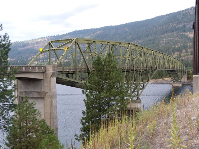
This bridge is an example of a typical cantilever through truss using a style that the Washington Department of Highways preferred. The distinctive cantilever style differs from those commonly found in other states in that the pointed towers above the roadway are eliminated by locating the extra truss depth required at the piers to below the deck. This design reduced the size and cost of piers.
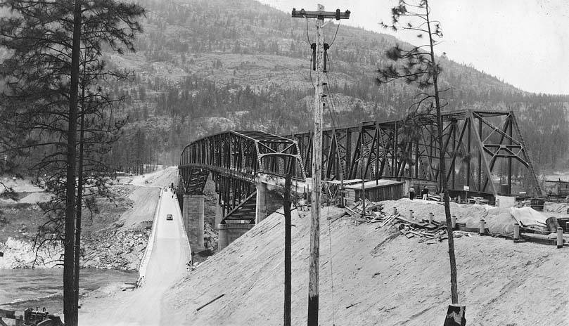
Romano and Company as the contractor for the superstructure and S. S. Mullen and Company was the substructure contractor.
The previous bridge at this location was built in 1929. Its replacement with the bridge seen today was required because of the massive reservoir created by the Grand Coulee Dam. Today, the water level reaches nearly to the deck of the previous bridge. Remains of the previous bridge's abutment can be found at the west end of the bridge.

A railroad bridge was built next to this bridge at the same time. Built at the exact same time over the exact same river right next to each other, the two bridges of the same general type (cantilevered through truss) with their vastly different design details and appearances contrast the different approach taken to bridge design by the railroad and the state highway department.


![]()
![]()
![]()

![]()
Coordinates (Latitude, Longitude):
Search For Additional Bridge Listings:
Bridgehunter.com: View listed bridges within 0.5 miles (0.8 kilometers) of this bridge.
Bridgehunter.com: View listed bridges within 10 miles (16 kilometers) of this bridge.
Additional Maps:
Google Streetview (If Available)
GeoHack (Additional Links and Coordinates)
Apple Maps (Via DuckDuckGo Search)
Apple Maps (Apple devices only)
Android: Open Location In Your Map or GPS App
Flickr Gallery (Find Nearby Photos)
Wikimedia Commons (Find Nearby Photos)
Directions Via Sygic For Android
Directions Via Sygic For iOS and Android Dolphin Browser
USGS National Map (United States Only)
Historical USGS Topo Maps (United States Only)
Historic Aerials (United States Only)
CalTopo Maps (United States Only)

© Copyright 2003-2024, HistoricBridges.org. All Rights Reserved. Disclaimer: HistoricBridges.org is a volunteer group of private citizens. HistoricBridges.org is NOT a government agency, does not represent or work with any governmental agencies, nor is it in any way associated with any government agency or any non-profit organization. While we strive for accuracy in our factual content, HistoricBridges.org offers no guarantee of accuracy. Information is provided "as is" without warranty of any kind, either expressed or implied. Information could include technical inaccuracies or errors of omission. Opinions and commentary are the opinions of the respective HistoricBridges.org member who made them and do not necessarily represent the views of anyone else, including any outside photographers whose images may appear on the page in which the commentary appears. HistoricBridges.org does not bear any responsibility for any consequences resulting from the use of this or any other HistoricBridges.org information. Owners and users of bridges have the responsibility of correctly following all applicable laws, rules, and regulations, regardless of any HistoricBridges.org information.
![]()