

View Information About HSR Ratings
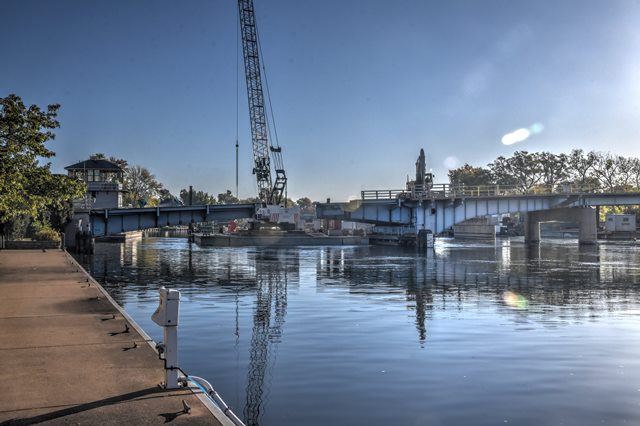
Like so many of Wisconsin's historic highway bridges, this unusual bascule bridge was demolished and replaced. It is unusual for a couple reasons. The bascule span is not in the center of the bridge, it is at the far north end, which might seem odd, but this is because the river has a canal and locks on the north shore west of the bridge. More unusual is the single span, assymetrical variable depth deck plate girder span immediately south of the bascule span. This span almost looks like another bascule span of single leaf design in appearance, but it is of fixed design. It appears to be designed to compensate for the lower bascule pier as well as the grade, as the unusual bascule location at the end of the bridge means the center approach spans are actually higher than the bascule span. However it looked unusual and contrasted with the other approach spans which were steel stringers.
HistoricBridges.org intended to photo-document this historic bridge as part of an October 2021 visit to Wisconsin. However the bridge was half demolished on arrival. HistoricBridges.org is still featuring a webpage for this bridge with photos of what was left to the bridge for a simple reason: to demonstrate the risk that historic bridges in Wisconsin face. Very few of Wisconsin's historic bridges have been preserved. Wisconsin is unusual because it has more historic railroad bridges than highway bridges, thanks to this aggressive demolition.
The only good news is there was still enough of this half-demolished bridge still standing so that a sense of how unusual this bascule bridge was, can still be seen in the photos.
![]()
![]()
![]()
This historic bridge has been demolished. This map is shown for reference purposes only.
Coordinates (Latitude, Longitude):
Search For Additional Bridge Listings:
Bridgehunter.com: View listed bridges within 0.5 miles (0.8 kilometers) of this bridge.
Bridgehunter.com: View listed bridges within 10 miles (16 kilometers) of this bridge.
Additional Maps:
Google Streetview (If Available)
GeoHack (Additional Links and Coordinates)
Apple Maps (Via DuckDuckGo Search)
Apple Maps (Apple devices only)
Android: Open Location In Your Map or GPS App
Flickr Gallery (Find Nearby Photos)
Wikimedia Commons (Find Nearby Photos)
Directions Via Sygic For Android
Directions Via Sygic For iOS and Android Dolphin Browser
USGS National Map (United States Only)
Historical USGS Topo Maps (United States Only)
Historic Aerials (United States Only)
CalTopo Maps (United States Only)

© Copyright 2003-2024, HistoricBridges.org. All Rights Reserved. Disclaimer: HistoricBridges.org is a volunteer group of private citizens. HistoricBridges.org is NOT a government agency, does not represent or work with any governmental agencies, nor is it in any way associated with any government agency or any non-profit organization. While we strive for accuracy in our factual content, HistoricBridges.org offers no guarantee of accuracy. Information is provided "as is" without warranty of any kind, either expressed or implied. Information could include technical inaccuracies or errors of omission. Opinions and commentary are the opinions of the respective HistoricBridges.org member who made them and do not necessarily represent the views of anyone else, including any outside photographers whose images may appear on the page in which the commentary appears. HistoricBridges.org does not bear any responsibility for any consequences resulting from the use of this or any other HistoricBridges.org information. Owners and users of bridges have the responsibility of correctly following all applicable laws, rules, and regulations, regardless of any HistoricBridges.org information.
![]()