

View Information About HSR Ratings
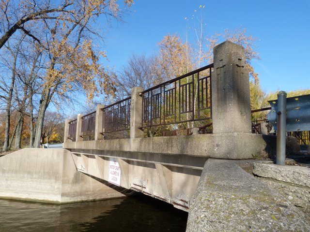
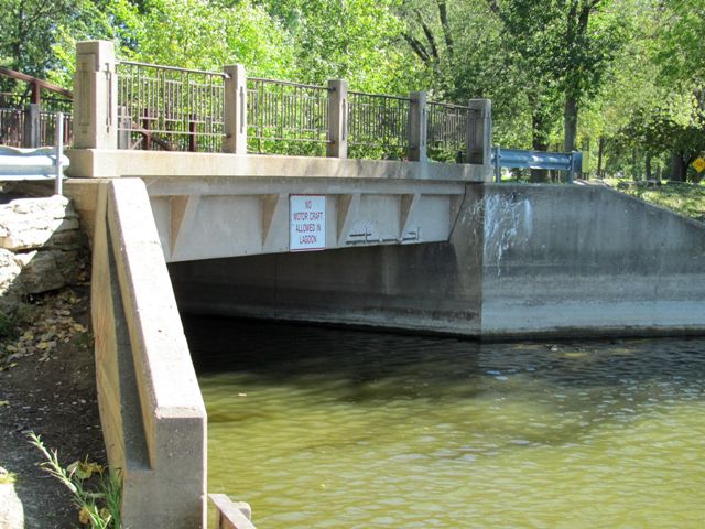
The Riverside Park Drive Bridge in Grand Rapids is an unassuming little bridge that may have been what inspired the Michigan State Highway Department to develop the R4 standard railing as seen on bridges like the Ojibway Island Bridge. With a given construction date of 1930, before the R4 standard was developed, the bridge has railings that are different but extremely similar to the first generation R4 railings. The concrete posts, while narrower, have the same inset architectural detailing on the faces. The metal panels are significantly different in construction and proportions and are very lightweight, but the overall architectural arrangement of the parts is the same. It is assumed this bridge was built by the city, since it is located in a park. The City of Grand Rapids unfortunately does not retain plans for this bridge however and did not know if there was a connection to MSHD's R4 railing standard. Unless more extensive research yields additional information about either this bridge or the development of the R4 railing standard, the truth may never be known, but it seems possible that this bridge may have inspired the R4 railing standard. At the same point, it is worth noting that the city did not even know where the 1930 construction date listed in the National Bridge Inventory came from, so there is also the remote possibility that the bridge dates to after the R4 railing standard was developed, which would invalidate the entire theory.
This bridge provides the only public vehicular access to a boat launch and picnic shelter. This access road is closed in the winter, so the bridge does not experience winter deicing salts any more, which should greatly prolong the life of the structure.
This bridge is tagged with the following special condition(s): Unorganized Photos
![]()
![]()
![]()
![]()
![]()
Coordinates (Latitude, Longitude):
Search For Additional Bridge Listings:
Bridgehunter.com: View listed bridges within 0.5 miles (0.8 kilometers) of this bridge.
Bridgehunter.com: View listed bridges within 10 miles (16 kilometers) of this bridge.
Additional Maps:
Google Streetview (If Available)
GeoHack (Additional Links and Coordinates)
Apple Maps (Via DuckDuckGo Search)
Apple Maps (Apple devices only)
Android: Open Location In Your Map or GPS App
Flickr Gallery (Find Nearby Photos)
Wikimedia Commons (Find Nearby Photos)
Directions Via Sygic For Android
Directions Via Sygic For iOS and Android Dolphin Browser
USGS National Map (United States Only)
Historical USGS Topo Maps (United States Only)
Historic Aerials (United States Only)
CalTopo Maps (United States Only)

© Copyright 2003-2024, HistoricBridges.org. All Rights Reserved. Disclaimer: HistoricBridges.org is a volunteer group of private citizens. HistoricBridges.org is NOT a government agency, does not represent or work with any governmental agencies, nor is it in any way associated with any government agency or any non-profit organization. While we strive for accuracy in our factual content, HistoricBridges.org offers no guarantee of accuracy. Information is provided "as is" without warranty of any kind, either expressed or implied. Information could include technical inaccuracies or errors of omission. Opinions and commentary are the opinions of the respective HistoricBridges.org member who made them and do not necessarily represent the views of anyone else, including any outside photographers whose images may appear on the page in which the commentary appears. HistoricBridges.org does not bear any responsibility for any consequences resulting from the use of this or any other HistoricBridges.org information. Owners and users of bridges have the responsibility of correctly following all applicable laws, rules, and regulations, regardless of any HistoricBridges.org information.
![]()