

View Information About HSR Ratings
This bridge actually consists of two structures, an 1869 stone arch bridge over Assunpink Creek and the 1891 Whipple truss span over the railroad. Due to time and weather-related concerns, HistoricBridges.org only took on-bridge photographs of the Whipple truss, no photos of the stone arch spans. Two aerial photos from the Historic American Engineering Record dated to 1977 show the entire bridge with the two spans. HAER was documenting the Pennsylvania Railroad, no bridge-specific documentation was done. The bridge does earn high praise from the state's Historic Bridge Inventory however.
The stone arch portion of the bridge was extensively rehabilitated in 2018.
The builder of the Whipple truss is unknown, but it was designed under the direction of the Pennsylvania Railroad. Henry Finch was the architect for the 1869 stone arch span, and the stone arch span was built by A. Carlile.
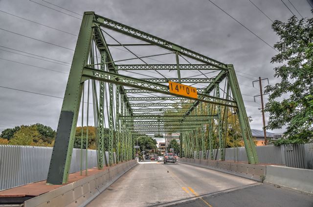
The Whipple truss is noted as a rare example of a surviving Whipple truss built in an urban setting (and thus having a relatively wide 24 foot roadway) and also rare as a skewed pin-connected truss bridge.


Information and Findings From New Jersey's Historic Bridge InventoryTruss Span (Built 1891) Summary The heavily skewed pin-connected double-intersection Pratt thru truss is a rare example of an unusual type. It stands in well preserved condition although a modern aluminum curb barrier covers the lower portion of the truss. The bridge was rehabilitated in 1981. In addition to its engineering significance, it is part of the historic transportation networks in Trenton, a town that grew because of and in response to transportation systems. Setting/Context The bridge is located in downtown Trenton and carries a 2-lane street over the main electrified line of Amtrak's Northeast Corridor. The depressed right-of-way has a brownstone ashlar retaining wall. The west end of the bridge rests on the 1869 stone arch across Assunpink Creek. The bridge is in full sight of the Pennsylvania Railroad's Trenton passenger terminal (now NJT). Surrounding area has been cleared and/or redeveloped. Physical Description The 10 panel pin-connected double intersection Pratt skewed thru truss bridge is a half hip with the inclined end post and top chord composed of steel channels and plates. Deep trusses designed for heavy live loads, the bridge has upper and lower lattice sway bracing. Laced channels make up the verticals, and the diagonals are bar stock while the counters are rods. The bridge was strengthened in 1981 by post tensioning the trusses with cables. New stringers and wearing surface were also installed as was an aluminum safety shape barrier, attached to the flooring system, not the trusses. The remedial work is not intrusive. The bridge is supported on ashlar abutments that predate the present span. The northeast side bearings rest on the 1869 stone arch that crosses Assunpink Creek. Historical and Technological Significance The well-preserved skewed Pratt thru truss bridge was built in 1891 (fabricator unknown) after plans developed by the Pennsylvania Railroad's Office of the Chief Engineer (William H. Brown). It stands as a good example of late-19th century pin-connected metal truss technology and a truss type (double intersection Pratt or Whipple) that is not common. The truss type as well as its depth reflect the anticipated loading the bridge needed to support. Using the 1869 2-span stone arch at its northeast end as its seat, the truss bridge and the stone arch work in tandem to carry a local street over four tracks of the former Pennsylvania Railroad (Amtrak's main electrified line) and the channeled creek the tracks parallel. The pair represent the two dominant bridge technologies of the 19th century and as such are an important record of 19th-century technology. The truss bridge was apparently installed when the Pennsylvania Railroad four-tracked its main line through Trenton. The right-of-way was established in 1862 when the Camden and Amboy Railroad (absorbed by the Pennsylvania system in 1871) realigned and thus straightened its route through the city. At that time the station was moved to S. Clinton Street. What type of structures serviced the crossing of the tracks and creek prior to 1869 are not known. Assunpink Creek originally crossed under the tracks between the vehicular bridge and the station. The creek was realigned in its present configuration prior to 1891. A. G. Lichtenstein and Associates prepared bridge rehabilitation plans for NJDOT in 1979, and the work was done in 1981. The aluminum safety shape protects the lower portion of the trusses and the pin connections (not visible but still in place). Any replacement of original/early members was done in kind. Boundary Description and Justification The bridge is individually eligible, as is the contiguous stone arch bridge (1100052) that forms the north abutment of this bridge. The two bridges together form one resource that works in tandem to cross the creek and the railroad tracks that parallel the creek. The stone bridge was modified to accommodate the erection of the metal truss bridge. The metal truss bridge was built as part of the Pennsylvania Railroad's improvements of the station and right-of-way, but the setting has been changed greatly with the removal of the historic stations and surrounding buildings. thus, the historic boundary is limited to the substructure and superstructure of the metal truss and stone arch bridges. Stone Arch Span (Built 1869) Summary One of several well-preserved multi-span stone arches in downtown Trenton, the 1869 rubble ashlar double barrel arch bridge with high spandrels was designed by local architect Henry Finch. The beam guard rail and pipe railing are modern as is the icebreaker. The arch bridge serves the abutment of an 1892 thru truss span, and the pair provide a rare tandem example of 19th-century solutions to engineering and transportation considerations. The crossing is one of the most historic in Trenton. Setting/Context The bridge over channeled Assunpink Creek in downtown Trenton is next to the former Pennsylvania RR passenger station. The station was moved to this location in the early 1860s. The south end of the stone bridge serves as the abutment for the contiguous 1892 truss bridge that crosses the tracks immediately east of the channeled creek. Much of the area surrounding the bridge has been cleared or redeveloped. Physical Description The well-proportioned 2-span random ashlar brownstone stone arch bridge with a deep spandrel has uniform ring stones, a keystone, and cap stones. Each arch has a 20' rise and is 36' wide. The structure continues into a curved wing wall on the north side. The bridge is the northern portion of a two-bridge arrangement that carries the local street over Assunpink Creek and the main line of the Camden and Amboy Railroad (Pennsylvania Railroad after 1871) which parallels the creek. The railroad right-of-way was established in 1862 as part of the line's realignment and double tracking through Trenton. Any original railing has been replaced by 20th-century pipe railing and modern steel guide rail. A concrete bullnose cutwater has been added to the upstream side, and a concrete wall directs the upstream channel of Assunpink Creek. The bridge is well preserved. Historical and Technological Significance The handsome stone arch bridge, designed by notable local architect Henry E. Finch, is part of the most significant pair of bridges in the area. Serving as the seat for the 1891 pin-connected double intersection Pratt truss that crosses four active lines of track at the west end of the main Trenton station, the stone arch is an integral part of the engineering solution to separate rail and local vehicular traffic as well as cross a water feature. The integrated pair of bridges represent two distinct epochs of 19th-century bridge technology, and that juxtaposition is rare if not unique. Boundary Description and Justification The arch was designed by Henry E. Finch, a prominent Trenton architect who designed approximately 2,000 buildings in the city (Trenton Public Library. Trentoniana Collection. Architects Vertical File). He came to Trenton in 1855 and served his apprenticeship with architect Chauncey Graham, his first partner. In 1863 Mr. Finch established his own practice and went on to become the most prominent and prolific local architect. He designed residences, many in brownstone, the material he specified for his arch bridges, and factories. In addition to the South Clinton Street arch also designed the E. State Street (1100053) and Montgomery Street (1100051) stone arch bridges. Finch had retired from practice by 1923. The stone arch bridge is one of four of its type from the 19th century that remain in downtown Trenton. No original plans for the bridge survive, but A. Carlile is listed in county records as the contractor. Sources Bridge Considered Historic By Survey: Yes |
![]()
![]()
![]()
Coordinates (Latitude, Longitude):
Search For Additional Bridge Listings:
Bridgehunter.com: View listed bridges within 0.5 miles (0.8 kilometers) of this bridge.
Bridgehunter.com: View listed bridges within 10 miles (16 kilometers) of this bridge.
Additional Maps:
Google Streetview (If Available)
GeoHack (Additional Links and Coordinates)
Apple Maps (Via DuckDuckGo Search)
Apple Maps (Apple devices only)
Android: Open Location In Your Map or GPS App
Flickr Gallery (Find Nearby Photos)
Wikimedia Commons (Find Nearby Photos)
Directions Via Sygic For Android
Directions Via Sygic For iOS and Android Dolphin Browser
USGS National Map (United States Only)
Historical USGS Topo Maps (United States Only)
Historic Aerials (United States Only)
CalTopo Maps (United States Only)

© Copyright 2003-2024, HistoricBridges.org. All Rights Reserved. Disclaimer: HistoricBridges.org is a volunteer group of private citizens. HistoricBridges.org is NOT a government agency, does not represent or work with any governmental agencies, nor is it in any way associated with any government agency or any non-profit organization. While we strive for accuracy in our factual content, HistoricBridges.org offers no guarantee of accuracy. Information is provided "as is" without warranty of any kind, either expressed or implied. Information could include technical inaccuracies or errors of omission. Opinions and commentary are the opinions of the respective HistoricBridges.org member who made them and do not necessarily represent the views of anyone else, including any outside photographers whose images may appear on the page in which the commentary appears. HistoricBridges.org does not bear any responsibility for any consequences resulting from the use of this or any other HistoricBridges.org information. Owners and users of bridges have the responsibility of correctly following all applicable laws, rules, and regulations, regardless of any HistoricBridges.org information.
![]()