

View Information About HSR Ratings
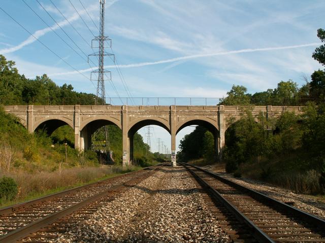
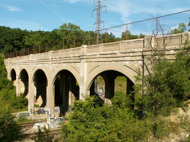
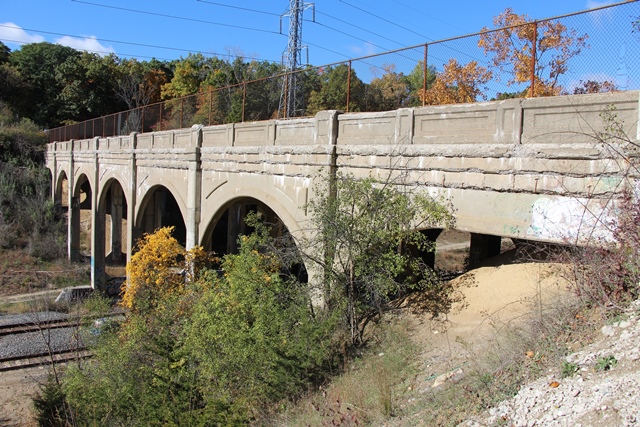
This bridge has the appearance of an arch bridge, although it is not really an arch bridge. It is the same design as the Derby Street Bridge, but with false arches added to it. The arches were added to the Trowbridge Road Bridge because it is a taller bridge and these arches help brace and stabilize the taller support system. The bridge is composed of seven spans, supported by concrete piers and seated on concrete abutments. Each span is 33 feet in length yielding a total bridge length of 231 feet. The bridge was constructed in 1930 but not completed until 1931.
The arches on the bridge add a striking beauty to the bridge that is refreshingly different. Most multi-span arch bridges have a shallower arch shape, and so the tall arches of this bridge are quite unusual looking. Triangles embossed on the corners of the arches add accent to the bridge. Railings are a design that features inset rectangles. The railings on the Trowbridge Road Bridge are spalling, and a lack of maintenance and preservation is apparent, and is most disappointing. The Derby Street Bridge has in contrast been painted and was in overall better shape as a result.
There is a private drive sign posted as you turned off of Kensington Road onto Trowbridge Road. Also, it had a newish-looking sign actually naming the road "Trowbridge Court." It would appear that the people that live in this area want to make themselves feel more like a gated community. The legality of the private drive signs is unclear, since this road appears to be maintained by the city (and thus funded through public dollars) and therefore should be considered open to the public. This is a beautiful historic bridge featuring rare design, and associated with am important event in southeastern Michigan history and every effort should be made to preserve this bridge and make it accessible and inviting to the public. In particular, a viewing platform and perhaps a walking trail of some sort should be installed near the bridge to allow people to easily and safely view the beautiful arches of the structure.
This bridge is tagged with the following special condition(s): Unorganized Photos
![]()
![]()
![]()

![]()
![]()
![]()
This historic bridge has been demolished. This map is shown for reference purposes only.
Coordinates (Latitude, Longitude):
Search For Additional Bridge Listings:
Bridgehunter.com: View listed bridges within 0.5 miles (0.8 kilometers) of this bridge.
Bridgehunter.com: View listed bridges within 10 miles (16 kilometers) of this bridge.
Additional Maps:
Google Streetview (If Available)
GeoHack (Additional Links and Coordinates)
Apple Maps (Via DuckDuckGo Search)
Apple Maps (Apple devices only)
Android: Open Location In Your Map or GPS App
Flickr Gallery (Find Nearby Photos)
Wikimedia Commons (Find Nearby Photos)
Directions Via Sygic For Android
Directions Via Sygic For iOS and Android Dolphin Browser
USGS National Map (United States Only)
Historical USGS Topo Maps (United States Only)
Historic Aerials (United States Only)
CalTopo Maps (United States Only)

© Copyright 2003-2025, HistoricBridges.org. All Rights Reserved. Disclaimer: HistoricBridges.org is a volunteer group of private citizens. HistoricBridges.org is NOT a government agency, does not represent or work with any governmental agencies, nor is it in any way associated with any government agency or any non-profit organization. While we strive for accuracy in our factual content, HistoricBridges.org offers no guarantee of accuracy. Information is provided "as is" without warranty of any kind, either expressed or implied. Information could include technical inaccuracies or errors of omission. Opinions and commentary are the opinions of the respective HistoricBridges.org member who made them and do not necessarily represent the views of anyone else, including any outside photographers whose images may appear on the page in which the commentary appears. HistoricBridges.org does not bear any responsibility for any consequences resulting from the use of this or any other HistoricBridges.org information. Owners and users of bridges have the responsibility of correctly following all applicable laws, rules, and regulations, regardless of any HistoricBridges.org information.
![]()