

View Information About HSR Ratings
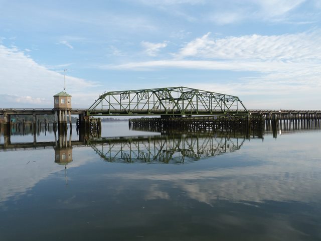
A number of sources including HAER list the construction date for this bridge as 1922 and altered in 1954. This is extremely misleading. In 1954, the entire main span (the through swing swing span) of the bridge was demolished and replaced, and all concrete t-beam, approach spans were widened by adding beams in 1954. This would have required replacing all approach railing. Therefore, the only 1922 elements of the bridge are portions of the approach spans and substructure. HistoricBridges.org defines the main construction date for a bridge as the date in which the main span superstructure of the bridge was built, so a 1954 construction date is listed. This is further appropriate since the main span is the element of the bridge described as having historical significance.
As a 1954 swing span, this is a late example of its type nationwide, but is significant on the state level as one of the only examples of this bridge type in Georgia.
The bridge in general retains good historic integrity as a 1954 swing bridge. The main exception is that the bridge tender house which was over the roadway in the center of the swing span was removed and replaced with a new bridge tender house located at the western end of the swing span.
Information and Findings From Georgia's Historic Bridge InventoryDiscussion of Bridge The 51 span bridge consists of a swing span bridge with thru truss superstructure and T beam approach spans. Originally constructed in 1922, the bridge had an 18'-wide roadway. In 1954 the bridge was widened by removal of the original swing span bridge and replacement with a new 12' wider structure built by the American Bridge Co. The T beam spans were retained but widened by T beam additions of 6' to each side. Original concrete balustrades were removed and replaced with standard concrete railings. The 1954 swing span bridge is technologically significant as 1 of only 2 identified swing span bridges (the other dates to 1940, 309-0016-0). It is a late example of the swing span technology, which reached its greatest period of popularity around 1900. The truss is rivet-connected with rolled steel sections. Discussion of Surrounding Area The bridge carries a 2-lane state highway over the navigable Front River channel of the Savannah River at Port Wentworth. The bridge is on the Ocean Highway at the border of Georgia and South Carolina. SR 25 (Ocean Highway) was developed by the state highway department and the Coastal Highway District as a 155-mile long link in a chain of highways running the full length of the southern Atlantic seaboard. The route was completed by stages from north to south from 1922 to 1930, when the route had been concrete-surfaced for its entire length in Georgia. The bridge is part of a 6 bridge causeway over the Savannah River complex (051-0055-0, other bridges in SC jurisdiction) that was completed in 1922 and widened in 1954. Southwest of the bridge is a memorial plaque to the Coastal Highway. Southeast of the bridge is a boat launch and playground. The area to the north and west of the bridge is undeveloped wetlands. Bridge Considered Historic By Survey: Yes |
![]()
![]()
![]()
Coordinates (Latitude, Longitude):
Search For Additional Bridge Listings:
Bridgehunter.com: View listed bridges within 0.5 miles (0.8 kilometers) of this bridge.
Bridgehunter.com: View listed bridges within 10 miles (16 kilometers) of this bridge.
Additional Maps:
Google Streetview (If Available)
GeoHack (Additional Links and Coordinates)
Apple Maps (Via DuckDuckGo Search)
Apple Maps (Apple devices only)
Android: Open Location In Your Map or GPS App
Flickr Gallery (Find Nearby Photos)
Wikimedia Commons (Find Nearby Photos)
Directions Via Sygic For Android
Directions Via Sygic For iOS and Android Dolphin Browser
USGS National Map (United States Only)
Historical USGS Topo Maps (United States Only)
Historic Aerials (United States Only)
CalTopo Maps (United States Only)

© Copyright 2003-2024, HistoricBridges.org. All Rights Reserved. Disclaimer: HistoricBridges.org is a volunteer group of private citizens. HistoricBridges.org is NOT a government agency, does not represent or work with any governmental agencies, nor is it in any way associated with any government agency or any non-profit organization. While we strive for accuracy in our factual content, HistoricBridges.org offers no guarantee of accuracy. Information is provided "as is" without warranty of any kind, either expressed or implied. Information could include technical inaccuracies or errors of omission. Opinions and commentary are the opinions of the respective HistoricBridges.org member who made them and do not necessarily represent the views of anyone else, including any outside photographers whose images may appear on the page in which the commentary appears. HistoricBridges.org does not bear any responsibility for any consequences resulting from the use of this or any other HistoricBridges.org information. Owners and users of bridges have the responsibility of correctly following all applicable laws, rules, and regulations, regardless of any HistoricBridges.org information.
![]()