

View Information About HSR Ratings
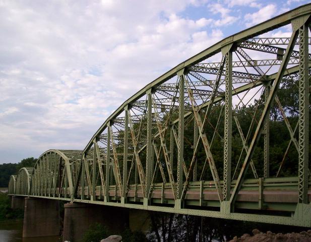
This is a large bridge that consists of four stunning truss spans. This bridge was likely built to a standard plan. Many states developed standard plans for metal truss bridges that were used as late as the 1940s, although over time the metal truss bridge declined drastically in popularity during that time. The idea of a standard plan does not mean that surviving examples are not rare or historic. This bridge type has not been built for a half century. Occasionally, modern truss bridges might be built, but they do not feature the use of rivets and/or built-up members and chords. Thus, a bridge like the Haysville Bridge may have been common when built, but is today an uncommon structure type that is quickly becoming rare. The fate of this bridge, which is being replaced, is a great example. Thus, bridges like this one should be preserved either next to their replacements for pedestrian used, or rehabilitated for continued service as a vehicular crossing, perhaps as a two-lane bridge, or next to a new one-lane bridge, forming a one-way couplet.
Information and Findings From DHPA Historic Bridge SurveyStatement of Significance This bridge is the earliest and one of the longest extant examples of the IDH's adjusted standard plan for 198' Parkers. Aside from contemporary guardrails, the structure retains its original members. Architectural Description The Indiana Department of Highways selected a modified version of its longest standard Parker through-truss design, as well as its traditional concrete substructure and coped and paneled approach rails, for this
setting. The IDH stiffened the outer diagonals and the lower chord to accommodate a wider deck. Bridge Considered Historic By Survey: Yes |
![]()
![]()
This historic bridge has been demolished. This map is shown for reference purposes only.
Coordinates (Latitude, Longitude):
Search For Additional Bridge Listings:
Bridgehunter.com: View listed bridges within 0.5 miles (0.8 kilometers) of this bridge.
Bridgehunter.com: View listed bridges within 10 miles (16 kilometers) of this bridge.
Additional Maps:
Google Streetview (If Available)
GeoHack (Additional Links and Coordinates)
Apple Maps (Via DuckDuckGo Search)
Apple Maps (Apple devices only)
Android: Open Location In Your Map or GPS App
Flickr Gallery (Find Nearby Photos)
Wikimedia Commons (Find Nearby Photos)
Directions Via Sygic For Android
Directions Via Sygic For iOS and Android Dolphin Browser
USGS National Map (United States Only)
Historical USGS Topo Maps (United States Only)
Historic Aerials (United States Only)
CalTopo Maps (United States Only)

© Copyright 2003-2025, HistoricBridges.org. All Rights Reserved. Disclaimer: HistoricBridges.org is a volunteer group of private citizens. HistoricBridges.org is NOT a government agency, does not represent or work with any governmental agencies, nor is it in any way associated with any government agency or any non-profit organization. While we strive for accuracy in our factual content, HistoricBridges.org offers no guarantee of accuracy. Information is provided "as is" without warranty of any kind, either expressed or implied. Information could include technical inaccuracies or errors of omission. Opinions and commentary are the opinions of the respective HistoricBridges.org member who made them and do not necessarily represent the views of anyone else, including any outside photographers whose images may appear on the page in which the commentary appears. HistoricBridges.org does not bear any responsibility for any consequences resulting from the use of this or any other HistoricBridges.org information. Owners and users of bridges have the responsibility of correctly following all applicable laws, rules, and regulations, regardless of any HistoricBridges.org information.
![]()