


View Information About HSR Ratings
 Introduction
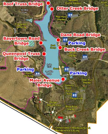
In addition to information specifically about the Dane Road Bridge, this special webpage also provides both an overview of F. W. Kent Park in general and a general discussion of all seven bridges that have been relocated and preserved on the Rod Dunlap Memorial Bridge Trail, followed by the discussion of the Dane Road Bridge specifically. Specific discussions for the other six bridges are located each on their own respective webpages. The map on this page shows F. W. Kent Park with all seven bridges labeled. You can click on the name of a bridge to switch to that bridge's page. Visit the official page for the park here. If you want to view an enlarged version of the bridge map to the left, click here.
F. W. Kent Park is one of the most unique county parks in the country. This is thanks to the Rod Dunlap Memorial Bridge Trail, which is a path for non-motorized traffic that rings the lake in the park, and includes seven historic truss bridges that were saved from demolition and relocated onto the trail. The bridges all came from Johnson County, which is nice because this means the bridges have remained in the county from which they came. A variety of truss bridges are represented on the trail including pony truss bridges, a bowstring truss bridge, a through truss bridge, and even a bridge that was built from a repurposed roof truss. When the bridges were relocated, repairs were made as needed to the trusses. Notably, no modern railings were added to the bridges, allowing the bridges to retain their original appearance. The only major alteration made to the bridges was that they were made more narrow before being placed on the trail. The bridges were not painted, which as long as salt is not applied to the trail in the winter should not be a major issue. Some of the bridges are likely made of wrought iron which weathers nicely, and even early steel does not deteriorated in the absence of paint like modern steel. Overall, the relocation of these bridges represents an outstanding preservation solution that is a model for the country. These are all bridges that would have been demolished if not moved here, and instead they have been given new life in a place where they can be safe from demolition. The bridges cross little fingers of the lake which extend inland.
The trail the bridges are on is named after Rod Dunlap who was the first direction of the Johnson County Conservation Board. He also developed F. W. Kent Park and was largely responsible for getting the historic bridges moved to the park.
The bridges have interpretive signage that is supported on the end posts of truss bridges. These are presumably from other truss bridges that were demolished in the county.
This bridge was likely dates to the 1870's. Its previous location was over a tributary of Old Man's Creek in Liberty Township on Dane Road. The bridge was moved to F.W. Kent Park in the late 1990's. The Dane Road Bridge is a rare example of a bowstring truss bridge and the most significant historic bridge on the trail. When HistoricBridges.org began operations in 2003, Iowa was one of the top two states for surviving bowstring truss bridges. Today, that number has vastly shrunk thanks both to flooding and even demolition (often under ridiculous circumstances). This bridge's type, which represents the first mass-produced type of metal bridge in the United States, is one of the most historically significant historic bridge types in the country. The bridges are sometimes called arch/truss bridges or even plain arch bridges since they present some of the function of an arch bridge as well as a truss bridge. This bridge is called a bowstring arch bridge by the signage in the park. Mostly built in the 1870s, this was a period of experimentation on the part of bridge companies and each company had its own distinctive (and often patented) bowstring truss design. This bridge is the work of the King Iron Bridge Company of Cleveland, Ohio. It displays the company's trademark built-up box top chord. Rolled star iron is present on the verticals and outriggers.
![]()
![]()
![]()
Coordinates (Latitude, Longitude):
Search For Additional Bridge Listings:
Bridgehunter.com: View listed bridges within 0.5 miles (0.8 kilometers) of this bridge.
Bridgehunter.com: View listed bridges within 10 miles (16 kilometers) of this bridge.
Additional Maps:
Google Streetview (If Available)
GeoHack (Additional Links and Coordinates)
Apple Maps (Via DuckDuckGo Search)
Apple Maps (Apple devices only)
Android: Open Location In Your Map or GPS App
Flickr Gallery (Find Nearby Photos)
Wikimedia Commons (Find Nearby Photos)
Directions Via Sygic For Android
Directions Via Sygic For iOS and Android Dolphin Browser
USGS National Map (United States Only)
Historical USGS Topo Maps (United States Only)
Historic Aerials (United States Only)
CalTopo Maps (United States Only)

© Copyright 2003-2025, HistoricBridges.org. All Rights Reserved. Disclaimer: HistoricBridges.org is a volunteer group of private citizens. HistoricBridges.org is NOT a government agency, does not represent or work with any governmental agencies, nor is it in any way associated with any government agency or any non-profit organization. While we strive for accuracy in our factual content, HistoricBridges.org offers no guarantee of accuracy. Information is provided "as is" without warranty of any kind, either expressed or implied. Information could include technical inaccuracies or errors of omission. Opinions and commentary are the opinions of the respective HistoricBridges.org member who made them and do not necessarily represent the views of anyone else, including any outside photographers whose images may appear on the page in which the commentary appears. HistoricBridges.org does not bear any responsibility for any consequences resulting from the use of this or any other HistoricBridges.org information. Owners and users of bridges have the responsibility of correctly following all applicable laws, rules, and regulations, regardless of any HistoricBridges.org information.
![]()