

View Information About HSR Ratings

The bridge has an interesting history. It was built in 1932, but in 1942 it was raised significantly to increase clearance above the water.
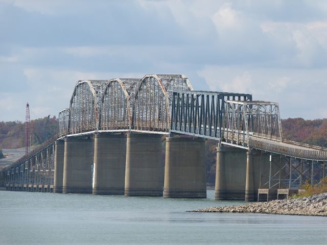
As originally designed, the bridge's main span components consisted of four Parker through truss spans and a single five panel Pratt through truss span at each end. The main spans are connected to the abutments by a long series of deck plate girder spans which are constructed with a substantial grade to bring the roadway up to the needed elevation.

On January 26, 2012 the boat Delta Mariner went under the wrong Parker truss span of the bridge, crashed into the span, and collapsed it. A replacement modern truss was built and lifted into place allowing the bridge to reopen to traffic on May 25, 2012.
Despite the historic significance of this bridge and despite the great expense of reopening the bridge following the accident, this bridge is nevertheless being replaced and will be demolished.
The consulting engineer for this bridge and the similar Lake Barkley Bridge was J. M. Johnson. Little is known about this engineer. A search online revealed a J. M. Johnson who in the years before this bridge was built worked for the Louisville Bridge and Iron Company (a noteworthy company that was originally formed by famous engineer Albert Fink) and this may be the same engineer, who later went off and did independent consulting as seen with this bridge. The plans drawn up for this bridge by Johnson show a personal attention to detail not found in modern bridge plans. The sketch showing the overview elevation of the bridge was drawn artfully on an image of a scroll as seen depicted on this page.


The above photos show the bridge as originally designed. Note that the steel bents extend down to the ground.


These photos show the project to raise the bridge. Note the construction of concrete bents upon which the original steel bents were placed.

This photo appears to show the jacking apparatus used to raise the spans.


Information and Findings From Replacement Project StudiesOverview Eggner's Ferry Bridge spans the Kentucky Lake (Tennessee River) from the vicinity of Aurora in Marshall County to Land Between the Lakes in Trigg County. Its location is shown in Figure 2 of the FONSI. The Eggner's Ferry Bridge meets National Register criterion A for its association with the Murphey Toll Bridge Act and the US Senate bill authorizing the Tennessee Valley Authority to change bridges to accommodate power dams. The boundaries of this National Register-eligible resource are the structure and ear. 1en embankment contained between the two shorelines of Kentucky Lake. Functional Characteristics The west approach to the bridge is on an earthen embankment that extends about two-thirds of the way to the river channel (600 meters/1,970 feet) , with the remaining approach distance (311 meters/1,020 feet) bridged by short steel beam spans. The Tennessee River main channel and the Marshall-Trigg County line are crossed by the six main through truss spans ( 499 meters/1,637 feet total). The east approach (556 meters/1 ,824 feet) continues across the lake to the eastern shore with about equal lengths of steel beam spans and earthen embankment. The bridge has 6.1 meters (20 feet) of clearance between the guard rails. Existing deficiencies of this bridge are described in section II of the FONS! under "Roadway and Major Bridge Deficiencies." These deficiencies include: narrow lanes, no shoulders, fractured and damaged members, inadequate seismic resistance strength, an undesirable horizontal navigation clearance, and an inadequate live load capacity. The bridge is owned by the State of Kentucky and maintained by the Kentucky Department of Highways. It is an integral part of US 68/KY 80, a principal east-west highway in Western Kentucky. US 68/KY 80 also serves as the only east-west highway into and through the Land Between the Lakes. The Eggner's Ferry Bridge connects the recreation opportunities offered by Kenlake State Resort Park (on the western shore of Kentucky Lake) with the Land Between the Lakes. (See Figure 2 of the FONSI.) Pedestrians and bicyclists cannot safely use the bridge because of its narrow width. Historical Characteristics The Eggner's Ferry Bridge was opened to the public on March 20, 1932 ("Eggner's Ferry Bridge to be Opened Today, Courier Journal, March 25, 1932, Section 1, p. 18). The Eggner's Ferry Bridge was funded by the Murphey Toll Bridge Act passed by the Kentucky legislature in 1928, which authorized the State Department of Highways to construct bridges over larger rivers in the state. The Murphey Toll Bridge Act allowed the state to sell bonds, secured by the bridges and tolls collected thereon, to construct, operate and maintain bridges. As the result of this act, bridges also were completed at Boonesboro, Spottsville and Tyrone to span the Kentucky River and at Burnside, Canton (Lawrence Memorial Bridge) and Smithland over the Cumberland River (Powell, 1991 : 40). In November 1941, the US Senate passed a bill authorizing the Tennessee Valley Authority to assume the
cost of altering, reconstructing, or re locating highway and railroad bridges in connection with the
construction of power dams ("Bill Passed to Let TVA Alter Bridges", Courier Journal, November 11 , 1941,
Section 2, p. 1) The Eggner's Ferry Bridge was directly affected because the water that was impounded
by the completion of the Kentucky Dam in 1944 inundated the bridge's approaches and reduced its
navigation clearance (Powell, 1991: 60). |
![]()
![]()
![]()

![]()
![]()
![]()
![]()
![]()
This historic bridge has been demolished. This map is shown for reference purposes only.
Coordinates (Latitude, Longitude):
Search For Additional Bridge Listings:
Bridgehunter.com: View listed bridges within 0.5 miles (0.8 kilometers) of this bridge.
Bridgehunter.com: View listed bridges within 10 miles (16 kilometers) of this bridge.
Additional Maps:
Google Streetview (If Available)
GeoHack (Additional Links and Coordinates)
Apple Maps (Via DuckDuckGo Search)
Apple Maps (Apple devices only)
Android: Open Location In Your Map or GPS App
Flickr Gallery (Find Nearby Photos)
Wikimedia Commons (Find Nearby Photos)
Directions Via Sygic For Android
Directions Via Sygic For iOS and Android Dolphin Browser
USGS National Map (United States Only)
Historical USGS Topo Maps (United States Only)
Historic Aerials (United States Only)
CalTopo Maps (United States Only)

© Copyright 2003-2025, HistoricBridges.org. All Rights Reserved. Disclaimer: HistoricBridges.org is a volunteer group of private citizens. HistoricBridges.org is NOT a government agency, does not represent or work with any governmental agencies, nor is it in any way associated with any government agency or any non-profit organization. While we strive for accuracy in our factual content, HistoricBridges.org offers no guarantee of accuracy. Information is provided "as is" without warranty of any kind, either expressed or implied. Information could include technical inaccuracies or errors of omission. Opinions and commentary are the opinions of the respective HistoricBridges.org member who made them and do not necessarily represent the views of anyone else, including any outside photographers whose images may appear on the page in which the commentary appears. HistoricBridges.org does not bear any responsibility for any consequences resulting from the use of this or any other HistoricBridges.org information. Owners and users of bridges have the responsibility of correctly following all applicable laws, rules, and regulations, regardless of any HistoricBridges.org information.
![]()