

View Information About HSR Ratings
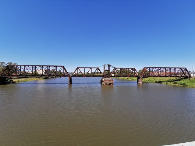
This large truss bridge has a variety of span types and ages, and has a complex history. Total length given is an estimate. The bridge appears to be a 1906-1907 truss sitting on 1882 substructure of a previous bridge.
From west to east the bridge is configured as follows. First, a five panel rivet connected Pratt through truss, about 125 foot span, dating to 1907 and built by A.M. Blodgett of Kansas City, Missouri. Next, a nine panel pin-connected Pratt through truss of about 245 foot span length. Depsite the different design (pin-connected), this span likely dates to 1906-1907 as well. Next, the rivet-connected through truss swing main span of 295 feet. It is believed this span dates to 1906, which is the construction date given by TranSystems, who rehabilitated the swing span pier in 2007. Lastly, another nine panel pin-connected Pratt through truss of about 245 foot span length.
The swing pier has been supplemented by new modern steel and concrete designed to deal with the original pier shifting. The original piers on the bridge are a rare brick design, and are assumed to date to the 1882 bridge.
![]()
![]()
![]()
Coordinates (Latitude, Longitude):
Search For Additional Bridge Listings:
Bridgehunter.com: View listed bridges within 0.5 miles (0.8 kilometers) of this bridge.
Bridgehunter.com: View listed bridges within 10 miles (16 kilometers) of this bridge.
Additional Maps:
Google Streetview (If Available)
GeoHack (Additional Links and Coordinates)
Apple Maps (Via DuckDuckGo Search)
Apple Maps (Apple devices only)
Android: Open Location In Your Map or GPS App
Flickr Gallery (Find Nearby Photos)
Wikimedia Commons (Find Nearby Photos)
Directions Via Sygic For Android
Directions Via Sygic For iOS and Android Dolphin Browser
USGS National Map (United States Only)
Historical USGS Topo Maps (United States Only)
Historic Aerials (United States Only)
CalTopo Maps (United States Only)

© Copyright 2003-2024, HistoricBridges.org. All Rights Reserved. Disclaimer: HistoricBridges.org is a volunteer group of private citizens. HistoricBridges.org is NOT a government agency, does not represent or work with any governmental agencies, nor is it in any way associated with any government agency or any non-profit organization. While we strive for accuracy in our factual content, HistoricBridges.org offers no guarantee of accuracy. Information is provided "as is" without warranty of any kind, either expressed or implied. Information could include technical inaccuracies or errors of omission. Opinions and commentary are the opinions of the respective HistoricBridges.org member who made them and do not necessarily represent the views of anyone else, including any outside photographers whose images may appear on the page in which the commentary appears. HistoricBridges.org does not bear any responsibility for any consequences resulting from the use of this or any other HistoricBridges.org information. Owners and users of bridges have the responsibility of correctly following all applicable laws, rules, and regulations, regardless of any HistoricBridges.org information.
![]()