

View Information About HSR Ratings
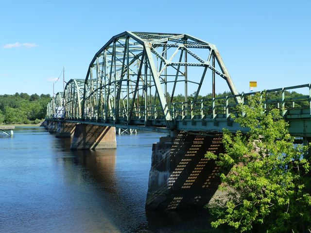
This bridge with a total of five through truss spans, this bridge is among the longer of Maine's surviving riveted metal truss bridges. One of the spans is also a swing span. Designed in a stylistically similar manner as the fixed spans, the swing span would be nearly impossible to pick out if it were not for the swing pier under the center of the span and the bridge tender house. The bridge also features continuous steel stringer approach spans. The bridge was built in 1931, but in the March 1936 flood, a mere five years after the bridge was built three spans were lost. They appear to have been reconstructed in kind, as it is not apparent which spans might date to after 1936.
Maine only has a small number of remaining movable bridges. Among Maine's swing bridges, this is one of the largest swing spans. The bridge is also noteworthy as a long, multi-span truss bridge in Maine. The bridge is eligible for the National Register of Historic Places. Despite this significance, the bridge is slated for demolition and replacement. Reasons given for demolition include structural deterioration and narrow roadway width. The structure deterioration could be corrected through rehabilitation instead. Another solution would be to leave the historic bridge standing next to a new replacement bridge. If needed, the swing span could be left in the open position to allow boats through. Even with the swing span open, the bridge could function as a scenic outlook for pedestrians and perhaps a fishing pier.
Information and Findings From Maine's Historic Bridge InventoryDiscussion of Bridge The center bearing, thru truss swing span bridge is historically and technologically significant as one of the state's two remaining thru truss swing span bridges. It was built in 1930-31 by a private toll bridge commission. The thru truss swing span and two other truss spans were lost in the 1936 flood. They were replaced in kind in 1937. The electrical operating system and center bearing were replaced 1988-1992. It is complete and operable, and it represents a movable bridge type that was once common in Maine and the nation. It is a later example, and its significance is derived primarily on the rareness of the significant bridge type/design. The fact that it is operable is an important aspect of its significance. The other thru truss swing span bridge is the 1939 Southport bridge. The bridge is judged to be a high preservation priority because it is a large, complicated example of a bridge type/design that is becoming rare in the state, and it is one of only two remaining thru truss swing span bridges in the state. The third truss swing span bridge in Maine is a pony truss. Bridge Considered Historic By Survey: Yes |
![]()
![]()

![]()
![]()
![]()
This historic bridge has been demolished. This map is shown for reference purposes only.
Coordinates (Latitude, Longitude):
Search For Additional Bridge Listings:
Bridgehunter.com: View listed bridges within 0.5 miles (0.8 kilometers) of this bridge.
Bridgehunter.com: View listed bridges within 10 miles (16 kilometers) of this bridge.
Additional Maps:
Google Streetview (If Available)
GeoHack (Additional Links and Coordinates)
Apple Maps (Via DuckDuckGo Search)
Apple Maps (Apple devices only)
Android: Open Location In Your Map or GPS App
Flickr Gallery (Find Nearby Photos)
Wikimedia Commons (Find Nearby Photos)
Directions Via Sygic For Android
Directions Via Sygic For iOS and Android Dolphin Browser
USGS National Map (United States Only)
Historical USGS Topo Maps (United States Only)
Historic Aerials (United States Only)
CalTopo Maps (United States Only)

© Copyright 2003-2024, HistoricBridges.org. All Rights Reserved. Disclaimer: HistoricBridges.org is a volunteer group of private citizens. HistoricBridges.org is NOT a government agency, does not represent or work with any governmental agencies, nor is it in any way associated with any government agency or any non-profit organization. While we strive for accuracy in our factual content, HistoricBridges.org offers no guarantee of accuracy. Information is provided "as is" without warranty of any kind, either expressed or implied. Information could include technical inaccuracies or errors of omission. Opinions and commentary are the opinions of the respective HistoricBridges.org member who made them and do not necessarily represent the views of anyone else, including any outside photographers whose images may appear on the page in which the commentary appears. HistoricBridges.org does not bear any responsibility for any consequences resulting from the use of this or any other HistoricBridges.org information. Owners and users of bridges have the responsibility of correctly following all applicable laws, rules, and regulations, regardless of any HistoricBridges.org information.
![]()