

View Information About HSR Ratings
Location:
Phoenix, Baltimore County, Maryland. A few miles east of
Interstate 83, about 20 miles north of Baltimore and 20 miles south of the
Maryland/Pennsylvania state line.
Date:
1879
Setting:
Rural,
amid woods, farms, and distant single-family houses on large lots.
Access:
Shawan Road/Hunt Valley exit from I-83. No parking available, but
traffic is very light, and you can pull over on a shoulder and get to the bridge
without too much trouble.
Crosses:
Carroll Branch
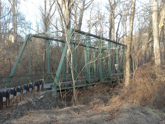
Current
Status:
One-lane bridge, wood deck, carries traffic on Carroll Road, a
narrow, winding two-lane road, at the intersection with Philpot Road.
Decorations/Plaques:
Plaque on truss over roadway provides the date of 1879.
There is also a very slight decoration using a circle design in the upper
corners of the truss.
Threats:
None known. However, the bridge is not
currently preserved or in a park. It does support traffic, and further suburban
development in the area could potentially increase traffic needs on the bridge.
The bridge is documented in "Historic Bridges of Maryland" by Dixie Legler and
Carol M. Highsmith.
The builder of this bridge is likely related to Gilbert and Smith of Gettysburg, Pennsylvania given the unusual pipe struts that this bridge shares with the John Eisenhowever Bridge, as well as the Gilbert name. Nelson refers to Thomas M. Nelson who later formed the more prolific company Nelson and Buchannan (and also acted as agents for Pittsburgh Bridge Company).
Its 1879 construction date makes it a very old example of a pin-connected Pratt truss.
![]()
![]()
![]()
Coordinates (Latitude, Longitude):
Search For Additional Bridge Listings:
Bridgehunter.com: View listed bridges within 0.5 miles (0.8 kilometers) of this bridge.
Bridgehunter.com: View listed bridges within 10 miles (16 kilometers) of this bridge.
Additional Maps:
Google Streetview (If Available)
GeoHack (Additional Links and Coordinates)
Apple Maps (Via DuckDuckGo Search)
Apple Maps (Apple devices only)
Android: Open Location In Your Map or GPS App
Flickr Gallery (Find Nearby Photos)
Wikimedia Commons (Find Nearby Photos)
Directions Via Sygic For Android
Directions Via Sygic For iOS and Android Dolphin Browser
USGS National Map (United States Only)
Historical USGS Topo Maps (United States Only)
Historic Aerials (United States Only)
CalTopo Maps (United States Only)

© Copyright 2003-2025, HistoricBridges.org. All Rights Reserved. Disclaimer: HistoricBridges.org is a volunteer group of private citizens. HistoricBridges.org is NOT a government agency, does not represent or work with any governmental agencies, nor is it in any way associated with any government agency or any non-profit organization. While we strive for accuracy in our factual content, HistoricBridges.org offers no guarantee of accuracy. Information is provided "as is" without warranty of any kind, either expressed or implied. Information could include technical inaccuracies or errors of omission. Opinions and commentary are the opinions of the respective HistoricBridges.org member who made them and do not necessarily represent the views of anyone else, including any outside photographers whose images may appear on the page in which the commentary appears. HistoricBridges.org does not bear any responsibility for any consequences resulting from the use of this or any other HistoricBridges.org information. Owners and users of bridges have the responsibility of correctly following all applicable laws, rules, and regulations, regardless of any HistoricBridges.org information.
![]()