

View Information About HSR Ratings
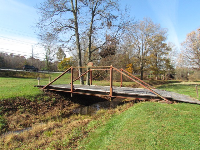
This is an exceedingly rare example of a bridge associated with famous engineer Wendel Bollman and it is also noted for cast iron elements. The bridge is owned by the Union Mills Homestead Foundation who recognizes its historic significance and is working to preserve it.
The Union Mills Homestead Foundation (www.unionmills.org) provided the following information:
The bridge at Union Mills was built in 1879 to carry Old Hanover Road over Big Pipe Creek. Robert M. Vogel, Curator of the Division of Mechanical and Civil Engineering of the Smithsonian Institution, found the bridge in 1968 and corresponded with Prof. Frederic S. Klein, then the director of the Union Mills Homestead Foundation, and Carroll County officials, urging the bridge's preservation. In the 1980s, County officials moved the bridge to its present location for use as a footbridge. The current location is just a few hundred yards from the original location where the original abutments can still be seen. We currently have a project underway to assess the bridge as there is some damage to some of its components. The preservation team is reviewing the history of the bridge and will make some preservation recommendations. To assist in their investigation, the team has been reviewing historical records. The records include files from the Smithsonian’s archives, including Robert Vogel’s photographs and annotated field drawings from 1968.
This bridge is tagged with the following special condition(s): Unorganized Photos
![]()
![]()
![]()
Coordinates (Latitude, Longitude):
Search For Additional Bridge Listings:
Bridgehunter.com: View listed bridges within 0.5 miles (0.8 kilometers) of this bridge.
Bridgehunter.com: View listed bridges within 10 miles (16 kilometers) of this bridge.
Additional Maps:
Google Streetview (If Available)
GeoHack (Additional Links and Coordinates)
Apple Maps (Via DuckDuckGo Search)
Apple Maps (Apple devices only)
Android: Open Location In Your Map or GPS App
Flickr Gallery (Find Nearby Photos)
Wikimedia Commons (Find Nearby Photos)
Directions Via Sygic For Android
Directions Via Sygic For iOS and Android Dolphin Browser
USGS National Map (United States Only)
Historical USGS Topo Maps (United States Only)
Historic Aerials (United States Only)
CalTopo Maps (United States Only)

© Copyright 2003-2024, HistoricBridges.org. All Rights Reserved. Disclaimer: HistoricBridges.org is a volunteer group of private citizens. HistoricBridges.org is NOT a government agency, does not represent or work with any governmental agencies, nor is it in any way associated with any government agency or any non-profit organization. While we strive for accuracy in our factual content, HistoricBridges.org offers no guarantee of accuracy. Information is provided "as is" without warranty of any kind, either expressed or implied. Information could include technical inaccuracies or errors of omission. Opinions and commentary are the opinions of the respective HistoricBridges.org member who made them and do not necessarily represent the views of anyone else, including any outside photographers whose images may appear on the page in which the commentary appears. HistoricBridges.org does not bear any responsibility for any consequences resulting from the use of this or any other HistoricBridges.org information. Owners and users of bridges have the responsibility of correctly following all applicable laws, rules, and regulations, regardless of any HistoricBridges.org information.
![]()