We Recommend:
Bach Steel - Experts at historic truss bridge restoration.
BridgeHunter.com Phase 1 is released to the public! - Visit Now
Gillespie Avenue Bridge

Primary Photographer(s): Nathan Holth and Rick McOmber
Bridge Documented: August 22, 2010 and November 15, 2014
Rural: Oakland County, Michigan: United States
1936 By Builder/Contractor: Unknown and Engineer/Design: Harold Hawley Corson
Not Available or Not Applicable
32.8 Feet (10 Meters)
33.8 Feet (10.3 Meters)
36 Feet (10.97 Meters)
1 Main Span(s)
634548400012B01

View Information About HSR Ratings
Bridge Documentation
View Archived National Bridge Inventory Report - Has Additional Details and Evaluation
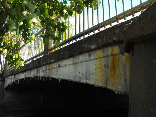
This small bridge is historically significant as an early example of a concrete rigid-frame bridge in Michigan. It also is a rare surviving example of the type in Michigan. Unlike the neighboring Canadian province of Ontario which built countless numbers of rigid-frames over a period of decades, Michigan does not appear to have built very many rigid-frames, even though the Michigan State Highway Department did have a standard plan for the bridge type. Either way, few examples survive in Michigan today. The Gillespie Avenue Bridge was not an example of the state standard plan however. It was built a year after the MSHD standard plan was developed, but was independently designed by Harold Hawley Corson, a consulting engineer.
Information and Findings From Michigan Historic Sites Online and the Michigan Historic Bridge InventoryNarrative Description Gillespie Street crosses the Clinton River just downstream from a dam that forms a lake tot he south. Chain-link fencing edges the south side of the Gillespie Street Bridge. Recessed panels ornament the shallow spandrels of this petite concrete rigid-frame structure. railings are simple metal panels with square-rod spindles supported by concrete posts trimmed with recessed panels. Sidewalks run along both sides of the roadway. Statement of Significance The Gillespie Street Bridge, built in 1936, is a relatively early example of rigid-frame construction in Michigan. Wayne County introduced rigid-frame bridges in the state in the early 1930s, and the Michigan State Highway Department adopted the design in 1935-1936. While the style was popular into the 1950s, few well-preserved structures of this type remain. The Gillespie Street Bridge is eligible for the National Register as an excellent example of concrete rigid-frame design. There was apparently no bridge at this site before the Gillespie Street Bridge was erected as part of the extension of that road. The city deepened the channel of the Clinton River at the same time that the bridge was built. The bridge was designed for the city of Pontiac by Harold Hawley Corson, a consulting engineer. Born in nearby Birmingham in 1886, Corson received a civil engineering degree from the University of Michigan. He worked on the construction of the Detroit River Tunnel and briefly employed by the U.S. Reclamation Service. From 1922 to 1927, he apparently did some consulting work for the Michigan State Highway Department. He returned to Birmingham in 1927, where he served as the town's engineer until at least the 1940s. It was during this period that he prepared the plans for the Gillespie Street Bridge for the city of Pontiac. It is unclear why he selected a rigid-frame design for this small span. Rigid-frame bridges had been introduced in Michigan a few years earlier, and he perhaps sought to experiment with this new bridge type at a modest scale. Rigid-frame bridges had initially appeared in Michigan in the early 1930s, and he perhaps sought to experiment with this new bridge type at a modest scale. The first concrete rigid-frame bridge in the United States was built in Westchester County, New York, in 1922. The design was considered both attractive and practical: it offered a broad, arch-like opening with a relatively shallow superstructure and a minimal loss of headroom beneath the span. As an interesting relatively early example of rigid-frame construction, the Gillespie Street Bridge is eligible for the National Register under Criterion C. |
![]()
Photo Galleries and Videos: Gillespie Avenue Bridge
Bridge Photo-Documentation
Original / Full Size PhotosA collection of overview and detail photos. This gallery offers photos in the highest available resolution and file size in a touch-friendly popup viewer.
Alternatively, Browse Without Using Viewer
![]()
Bridge Photo-Documentation
Mobile Optimized PhotosA collection of overview and detail photos. This gallery features data-friendly, fast-loading photos in a touch-friendly popup viewer.
Alternatively, Browse Without Using Viewer
![]()
Maps and Links: Gillespie Avenue Bridge
Coordinates (Latitude, Longitude):
Search For Additional Bridge Listings:
Bridgehunter.com: View listed bridges within 0.5 miles (0.8 kilometers) of this bridge.
Bridgehunter.com: View listed bridges within 10 miles (16 kilometers) of this bridge.
Additional Maps:
Google Streetview (If Available)
GeoHack (Additional Links and Coordinates)
Apple Maps (Via DuckDuckGo Search)
Apple Maps (Apple devices only)
Android: Open Location In Your Map or GPS App
Flickr Gallery (Find Nearby Photos)
Wikimedia Commons (Find Nearby Photos)
Directions Via Sygic For Android
Directions Via Sygic For iOS and Android Dolphin Browser
USGS National Map (United States Only)
Historical USGS Topo Maps (United States Only)
Historic Aerials (United States Only)
CalTopo Maps (United States Only)

