

View Information About HSR Ratings
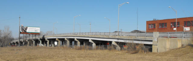
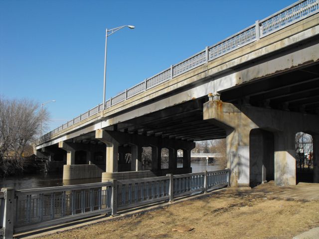
The Cedar Street Bridge is a state trunkline bridge that is an impressive structure, with its sweeping length and curved design, especially in a state that has very few historic bridges of this length. The bridge features an attractive railing that was Michigan's standard for the period (known by the Michigan State Highway Department as the R4 railing). The bridge serves BL-96, but the road was originally US-127 prior to the construction of the US-127 freeway. It is the main non-freeway north-south road through Lansing. The bridge's largest span over the river is 85 Feet (25.9 Meters) while the remaining spans are 60 Feet (18.2 Meters). The bridge has 2 sidewalks at 6 Feet (1.8 Meters) each. The bridge was rehabilitated in 1997 and 2005.
The bridge was fabricated by the American Bridge Company, a division of United States Steel. This bridge is one of the few known stringer highway bridges in Michigan to bear a fabricator plaque placed on its beams in addition to the typical bronze Michigan State Highway Department plaques located at the ends of the bridge on the railings. The MSHD plaque lists Fry and Kain and Walter Toebe, two different companies as contractors for the structure. Walter Toebe was a very prolific company in Michigan. Building bridges since at least the 1920s, they are still in business today, although the bridges they build today are boring slabs, and nothing like this graceful, sweeping structure.
When the Cedar Street Bridge was built, there also was a bridge built that crosses the Red Cedar river at low-level next to this bridge to carry Beech Street and prevent buildings in the area from being cut off by the new Cedar Street Bridge's long and higher level configuration. This bridge should have also been considered historically significant because it was a part of the Cedar Street Bridge construction project. Sadly however, this bridge was replaced just before this website photographed the Cedar Street Bridge, and thus the bridge is undocumented on this website, nor is it available for visitors to the bridge to see. The replacement at Beech Street is a slab of concrete that is ugly and not noteworthy for any reason.
This bridge is noteworthy as perhaps the only remaining historic highway bridge within the city limits of Lansing, despite a decent number of river crossings in the city. It is unclear why so many bridges have been demolished and replaced within Michigan's capital city. Either way, as the last historic highway bridge in the city, and as an impressive example of mid-20th Century bridge construction anywhere in the state, this bridge should be considered to be very important locally.
Fortunately, this state trunkline bridge was preserved by MDOT. While MDOT has certainly demolished many historic bridges on Michigan's trunklines (more than they should have) over the years, they also have a historic bridge preservation track record that is considerably higher and further ahead of the game when compared with other state highway agencies such as Pennsylvania's PennDOT and Ohio's ODOT, which offer very few preserved historic bridges on state-owned roadways (trunklines). It is interesting to look at preservation on state trunklines because often traffic is heavier both in terms of weight and quantity, which makes historic bridge preservation more challenging. Ignoring demolished bridges and only paying mind to the preserved bridges, MDOT has set the bar high for other state DOTs, by preserving bridges on busy roads and doing so in a way that respects the historic integrity of the bridge.
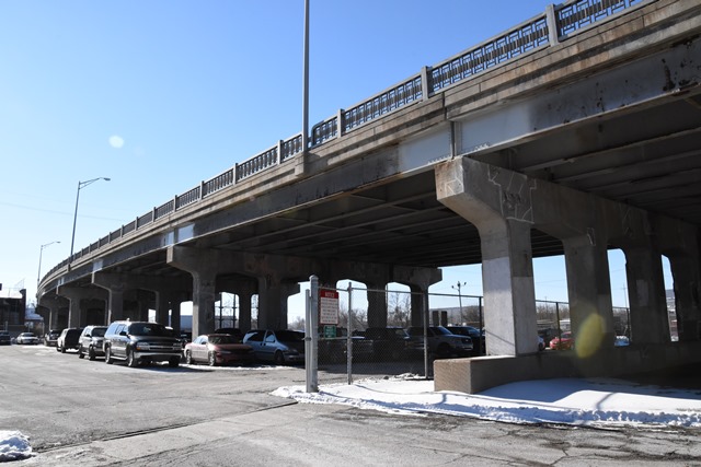
The Cedar Street Bridge is a typical MDOT preservation example using techniques that can be seen on other preserved bridges with similar characteristics and features. Most noteworthy: the original railings, the so-called "R-4" style were not removed from the bridge when an update to crash-tested barriers was required. Instead MDOT took the panels and attached them to special crash-tested guardrails. These guardrails feature low-profile steel rails attached to special metal posts that are also designed to hold the historic railing panels behind the crash-resistant rails. This solution meets crash-resistant standards, while making the bridge look almost unaltered when viewed from below. Even on the bridge, the low profile style of the crash railings allows the historic panels to be visible. With a relatively mundane structure type as a steel stringer, it is important that decorative railings be retained on the bridge to keep it looking attractive and historic. MDOT's solution is a good compromise between integrity and modern standards for crash-resistant barrier systems.
The steel stringers for the bridge are painted grey and retain good historic integrity. Original riveted diaphragms are visible under the bridge. The substructure (piers and abutments) also appears to be in good condition and original.
This bridge was surveyed in MDOT's historic bridge inventory, and a good history of the was composed from this. Read MDOT's findings below.
Information and Findings From Michigan Historic Bridge InventoryNarrative Description This long bridge crosses an industrial area, three
sets of railroad tracks, a city street, and the Red Cedar River. I-96
BL, formerly US-127, is known locally as South Cedar Street. Standard
State Highway Department railings with metal panels between metal posts
edge the roadway, terminating at concrete endposts. Railings also top
the long, sloping wing walls. Raised concrete sidewalks run on both
sides of the roadway. A bridge plate is affixed at the southeast corner.
|
This bridge is tagged with the following special condition(s): Unorganized Photos
![]()
![]()
![]()
![]()
![]()
Coordinates (Latitude, Longitude):
Search For Additional Bridge Listings:
Bridgehunter.com: View listed bridges within 0.5 miles (0.8 kilometers) of this bridge.
Bridgehunter.com: View listed bridges within 10 miles (16 kilometers) of this bridge.
Additional Maps:
Google Streetview (If Available)
GeoHack (Additional Links and Coordinates)
Apple Maps (Via DuckDuckGo Search)
Apple Maps (Apple devices only)
Android: Open Location In Your Map or GPS App
Flickr Gallery (Find Nearby Photos)
Wikimedia Commons (Find Nearby Photos)
Directions Via Sygic For Android
Directions Via Sygic For iOS and Android Dolphin Browser
USGS National Map (United States Only)
Historical USGS Topo Maps (United States Only)
Historic Aerials (United States Only)
CalTopo Maps (United States Only)

© Copyright 2003-2025, HistoricBridges.org. All Rights Reserved. Disclaimer: HistoricBridges.org is a volunteer group of private citizens. HistoricBridges.org is NOT a government agency, does not represent or work with any governmental agencies, nor is it in any way associated with any government agency or any non-profit organization. While we strive for accuracy in our factual content, HistoricBridges.org offers no guarantee of accuracy. Information is provided "as is" without warranty of any kind, either expressed or implied. Information could include technical inaccuracies or errors of omission. Opinions and commentary are the opinions of the respective HistoricBridges.org member who made them and do not necessarily represent the views of anyone else, including any outside photographers whose images may appear on the page in which the commentary appears. HistoricBridges.org does not bear any responsibility for any consequences resulting from the use of this or any other HistoricBridges.org information. Owners and users of bridges have the responsibility of correctly following all applicable laws, rules, and regulations, regardless of any HistoricBridges.org information.
![]()