

View Information About HSR Ratings
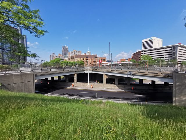
Whether you consider this two bridges or one unique "U" shaped bridge, either way it may be the last surviving example of a bridge using an unusual variation of Michigan's attractive R4 railings. The unique layout of this bridge carries two separate streets that are at an angle to each other as they pass over I-375. At the west end, the two streets meet at an intersection. Because of how the two streets meet at one end of the bridge, the two bridges are physically joined by some steel beams at the west end, which makes them in a sense one bridge. The railing on this bridge has a concrete parapet at the bottom with a short variation of an R4 railing on top. Prior to a major reconstruction, this railing type was used on bridges of the Southfield Freeway. They may have been present on other I-375 bridges at one time as well, but today this is the only known example on either freeway. Sadly, several railing sections have been damaged by people who apparantly struggle with the process of driving. These sections were replaced with concrete.
Dimensions and span numbers refer to the Jefferson Avenue portion of the bridge. See the National Bridge Inventory sheet for data on both bridges.
This bridge is likely at risk for demolition at some point in the distant future. There has been a national movement to turn "into-downtown" expressway spurs like this back into surface streets, to try to reverse some of the cultural damage done by constructing freeways like this. Indeed, one of the two bridges here is noted on the National Bridge Inventory as Hastings Street, perhaps the only remnant (near downtown) of what was once a street in a predmominently black neighbhorhood which was displaced by freeway construction. I-375 has been targeted for such a conversion, which would mean all bridges would be removed. Further for the city of Detroit, this freeway is a bit excessive for the amount of traffic actually flowing into downtown these days. Indeed, the interchange of I-75 with I-375 about a mile northwest of this bridge, is one of the most unusual interchanges in the city. I-75, which runs from Canada to Florida, is one of the most important north-south Interstates in the country (and in Michigan too) and sees massive seasonal traffic from snowbirds. At this interchange, mighty I-75 is squeezed into two lanes that curve through a very sharp ramp to simply stay on I-75. Meanwhile no less than four lanes continue straight as I-375. No doubt people not paying attention to signs or GPS have found themselves in downtown Detroit by mistake. Further, this lane arrangement does not recognize that most traffic stays on I-75. It seems reasonable to expect major changes to take place in this area in the future.
![]()
![]()
![]()
Coordinates (Latitude, Longitude):
Search For Additional Bridge Listings:
Bridgehunter.com: View listed bridges within 0.5 miles (0.8 kilometers) of this bridge.
Bridgehunter.com: View listed bridges within 10 miles (16 kilometers) of this bridge.
Additional Maps:
Google Streetview (If Available)
GeoHack (Additional Links and Coordinates)
Apple Maps (Via DuckDuckGo Search)
Apple Maps (Apple devices only)
Android: Open Location In Your Map or GPS App
Flickr Gallery (Find Nearby Photos)
Wikimedia Commons (Find Nearby Photos)
Directions Via Sygic For Android
Directions Via Sygic For iOS and Android Dolphin Browser
USGS National Map (United States Only)
Historical USGS Topo Maps (United States Only)
Historic Aerials (United States Only)
CalTopo Maps (United States Only)

© Copyright 2003-2024, HistoricBridges.org. All Rights Reserved. Disclaimer: HistoricBridges.org is a volunteer group of private citizens. HistoricBridges.org is NOT a government agency, does not represent or work with any governmental agencies, nor is it in any way associated with any government agency or any non-profit organization. While we strive for accuracy in our factual content, HistoricBridges.org offers no guarantee of accuracy. Information is provided "as is" without warranty of any kind, either expressed or implied. Information could include technical inaccuracies or errors of omission. Opinions and commentary are the opinions of the respective HistoricBridges.org member who made them and do not necessarily represent the views of anyone else, including any outside photographers whose images may appear on the page in which the commentary appears. HistoricBridges.org does not bear any responsibility for any consequences resulting from the use of this or any other HistoricBridges.org information. Owners and users of bridges have the responsibility of correctly following all applicable laws, rules, and regulations, regardless of any HistoricBridges.org information.
![]()