

View Information About HSR Ratings
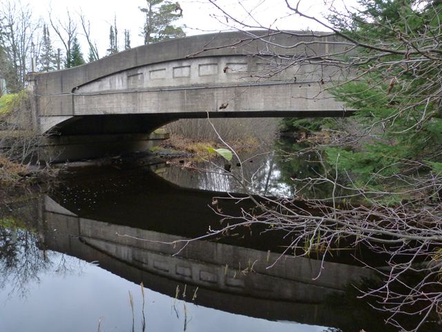
This bridge is a remnant of this road's trunk line past. This road used to be M-28, but is today a very rural local road since M-28 was realigned to a new location. Perhaps a result of its rural location and light traffic thanks to the realignment, this bridge remains today in good condition. One of the nice aspects of this bridge, thanks again to its rural road and local usage, is that it does not have modern approach Armco style guardrails. In fact, it has no approach guardrail of any kind. Only hazard signs are present at the end posts. It is a nice chance to see this bridge design without unsightly modern guardrails bolted into the sides of the girder end posts.
Information and Findings From Michigan Historic Bridge InventoryNarrative Description Crossing the Rock River in rural Covington Township, this medium-span concrete bridge carries Old M-28 about two miles east of the town of Covington. The structure is comprised of a single, 60-foot concrete
through girder span, with arched ribs that rest on angled concrete brackets cantilevered from the concrete abutments. A series of concrete floor beams span between the two girders; these are cast integrally with the 22-foot-wide
concrete deck. The arched girders feature typical MSHD detailing, with corbeled bulkheads and six panels recessed in the concrete spandrel walls. The Rock River Bridge is today in excellent condition, without alteration. |
![]()
![]()
![]()
Coordinates (Latitude, Longitude):
Search For Additional Bridge Listings:
Bridgehunter.com: View listed bridges within 0.5 miles (0.8 kilometers) of this bridge.
Bridgehunter.com: View listed bridges within 10 miles (16 kilometers) of this bridge.
Additional Maps:
Google Streetview (If Available)
GeoHack (Additional Links and Coordinates)
Apple Maps (Via DuckDuckGo Search)
Apple Maps (Apple devices only)
Android: Open Location In Your Map or GPS App
Flickr Gallery (Find Nearby Photos)
Wikimedia Commons (Find Nearby Photos)
Directions Via Sygic For Android
Directions Via Sygic For iOS and Android Dolphin Browser
USGS National Map (United States Only)
Historical USGS Topo Maps (United States Only)
Historic Aerials (United States Only)
CalTopo Maps (United States Only)

© Copyright 2003-2025, HistoricBridges.org. All Rights Reserved. Disclaimer: HistoricBridges.org is a volunteer group of private citizens. HistoricBridges.org is NOT a government agency, does not represent or work with any governmental agencies, nor is it in any way associated with any government agency or any non-profit organization. While we strive for accuracy in our factual content, HistoricBridges.org offers no guarantee of accuracy. Information is provided "as is" without warranty of any kind, either expressed or implied. Information could include technical inaccuracies or errors of omission. Opinions and commentary are the opinions of the respective HistoricBridges.org member who made them and do not necessarily represent the views of anyone else, including any outside photographers whose images may appear on the page in which the commentary appears. HistoricBridges.org does not bear any responsibility for any consequences resulting from the use of this or any other HistoricBridges.org information. Owners and users of bridges have the responsibility of correctly following all applicable laws, rules, and regulations, regardless of any HistoricBridges.org information.
![]()