HistoricBridges.org Menu: HistoricBridges.org Menu:


We Recommend:
Bach Steel - Experts at historic truss bridge restoration.

HistoricBridges.org: Bridge Browser

Ramsay Bridge

Ramsay Bridge

Primary Photographer(s): James Rouse

Bridge Documented: June 19, 2007

View Photos
and Videos
View Maps
and Links

Facility Carried / Feature Intersected
Main Street Over Black River
Location
Ramsay: Gogebic County, Michigan: United States
Structure Type
Concrete Through Girder, Fixed
Construction Date and Builder / Engineer
1922 By Builder/Contractor: P. N. Massie of Bessemer, Michigan and Engineer/Design: Michigan State Highway Department
Rehabilitation Date
Not Available or Not Applicable
Main Span Length
50.0 Feet (15.2 Meters)
Structure Length
130.0 Feet (39.6 Meters)
Roadway Width
22 Feet (6.71 Meters)
Spans
3 Main Span(s)
Inventory Number
27200005000B010

Historic Significance Rating (HSR)
View Information About HSR Ratings

Bridge Documentation

View Archived National Bridge Inventory Report - Has Additional Details and Evaluation

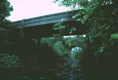
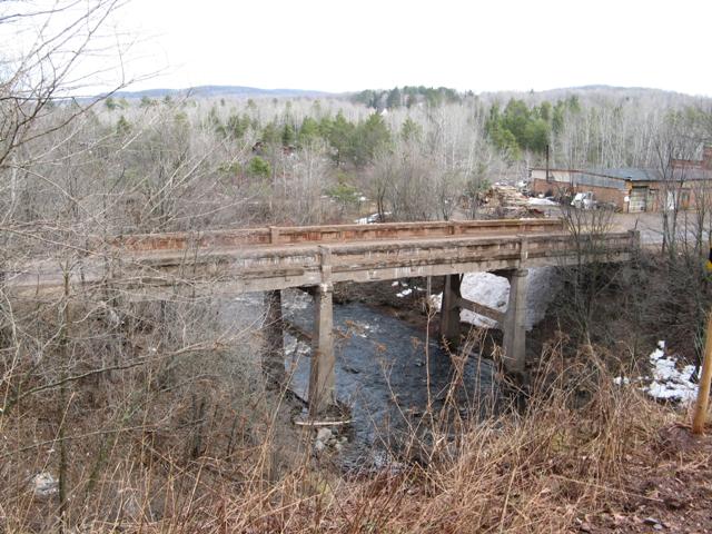
This bridge sits next to the equally rare and beautiful Keystone Bridge. The Ramsay Bridge is an impressive example of a concrete girder bridge, as it sweeps over the small valley of the Black River. Such use of the concrete girder bridge was not often seen in Michigan; concrete girders were generally used for smaller crossings that did not have a valley to them. The bridge is significant as the largest remaining example of a straight chord through girder bridge in Michigan. Unfortunately, the bridge has not been maintained and serious concrete spalling has marred the beauty of the structure. It is paramount that this bridge be restored, with attention paid to bringing back the original appearance of the bridge. As a significant and impressive example of this structure type, it should be receive more attention than it currently has been.

Information and Findings From Michigan Historic Bridge Inventory

Narrative Description

Main St. / Black River

This three-span concrete bridge carries Main Street over the Black River in the center of the village of Ramsay. Built in 1922-1923 from a design by the Michigan State Highway Department, the Ramsay Bridge is comprised of a 50-foot concrete through girder, flanked on both sides by similarly configured, 40-foot girders. The superstructure is supported by concrete abutments and spill-through piers with tapered columns and straight diaphragms. It features typical MSHD detailing with two straight girders that carry the asphalt-surfaced, concrete slab deck. The modest architectural expression is provided by recessed rectangular panels in the girder walls, which are capped with heavy concrete corbels. Bronze "State Reward Bridge" plates are mounted on the girder's sidewalls. Other than minor concrete spalling, the Ramsay Bridge remains essentially unaltered and in physically good condition.

Beginning in 1884, the village of Ramsay developed around Hubbard and Weed's sawmill on the Black River over a 19th century truss bridge, which, by the late 1910s had become a deteriorating bottleneck for vehicular traffic. In response, the Gogebic County Road Commission petitioned the state highway department for a replacement structure here, to be funded in part with State Reward monies. In 1922 MSHD engineers delineated this three-span concrete structure.

The structure that MSHD engineered for this crossing employed a well-tested standard. The department had first delineated a concrete through girder bridge design in the 1913-1914 biennium. Featuring relatively heavy, straight-topped girders in five-foot increments between 30 and 50 feet, these plainly detailed structures were used for a variety of small- and medium-span applications in the 1910s and 1920s. "The reinforced concrete through girder is the design generally employed for spans from thirty to fifty feet in both the eighteen and twenty-foot clear roadway from curb to curb," MSHD stated in its Seventh Biennial Report. "This design lends itself in the majority of cases on account of its very shallow floor system, thereby giving the waterway a maximum clearance under elevation of roadway crossing the bridge." By 1930 the through girder had largely fallen out of favor with the state and county highway departments, but before it was discontinued, perhaps hundreds of these utilitarian structures were built throughout the state. The overwhelming majority of these were single-span structures, built over relatively low substructures. With its three-span superstructure held aloft by gracefully tapered concrete piers, the Main Street Bridge in Ramsay is a noteworthy exception. As the central river crossing in this small village, it is historically important for its contribution to local transportation. And as a visually striking, multiple-span example of what is ordinarily a mundane structural type, it is technologically significant as well.

Divider

Photo Galleries and Videos: Ramsay Bridge


View Photo Gallery

Bridge Photo-Documentation

A collection of overview and detail photos. This photo gallery contains a combination of Original Size photos and Mobile Optimized photos in a touch-friendly popup viewer.
Alternatively, Browse Without Using Viewer

Divider

Maps and Links: Ramsay Bridge

Coordinates (Latitude, Longitude):

Search For Additional Bridge Listings:

Bridgehunter.com: View listed bridges within 0.5 miles (0.8 kilometers) of this bridge.

Bridgehunter.com: View listed bridges within 10 miles (16 kilometers) of this bridge.

HistoricBridges.org Bridge Browser: View listed bridges within 0.5 miles (0.8 kilometers) of this bridge.

HistoricBridges.org Bridge Browser: View listed bridges within 10 miles (16 kilometers) of this bridge.

2021 National Bridge Inventory: View listed bridges within 0.5 miles (0.8 kilometers) of this bridge.

Additional Maps:

Google Maps

Google Streetview (If Available)

Bing Maps

OpenStreetMap

GeoHack (Additional Links and Coordinates)

Apple Maps (Via DuckDuckGo Search)

Apple Maps (Apple devices only)

MapQuest

HERE We Go Maps

ACME Mapper

Waze Map

Android: Open Location In Your Map or GPS App

Flickr Gallery (Find Nearby Photos)

Wikimedia Commons (Find Nearby Photos)

Directions Via Sygic For Android

Directions Via Sygic For iOS and Android Dolphin Browser

USGS National Map (United States Only)

Historical USGS Topo Maps (United States Only)

Historic Aerials (United States Only)

CalTopo Maps (United States Only)


Divider
 
Home Top

Divider

About - Contact

© Copyright 2003-2024, HistoricBridges.org. All Rights Reserved. Disclaimer: HistoricBridges.org is a volunteer group of private citizens. HistoricBridges.org is NOT a government agency, does not represent or work with any governmental agencies, nor is it in any way associated with any government agency or any non-profit organization. While we strive for accuracy in our factual content, HistoricBridges.org offers no guarantee of accuracy. Information is provided "as is" without warranty of any kind, either expressed or implied. Information could include technical inaccuracies or errors of omission. Opinions and commentary are the opinions of the respective HistoricBridges.org member who made them and do not necessarily represent the views of anyone else, including any outside photographers whose images may appear on the page in which the commentary appears. HistoricBridges.org does not bear any responsibility for any consequences resulting from the use of this or any other HistoricBridges.org information. Owners and users of bridges have the responsibility of correctly following all applicable laws, rules, and regulations, regardless of any HistoricBridges.org information.

Admin Login

Divider