

View Information About HSR Ratings

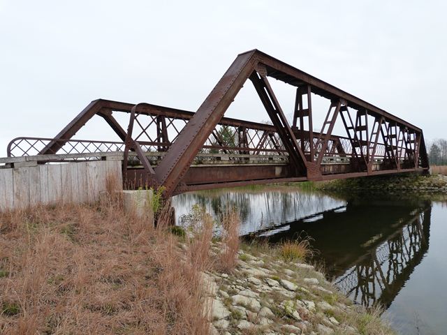
This bridge originally carried CR-497 over the Sturgeon River near Nahma, Michigan in Delta County. In 1995, it was closed to all traffic. In 2006, the bridge was taken off of its abutments and placed into storage and later relocated to the Sweetgrass Golf Course, which saved the bridge from demolition. In 2008, a new bridge was built in the former location of the historic bridge. At the Sweetgrass Golf Club, the historic bridge is the highlight of the course. The bridge leads to Turtle Island, where Hole 15, the signature hole of the course, is located.
This bridge is among the most historically significant pony truss bridges in Michigan. It has historic significance for several reasons. First, the bridge's 104 foot length is extremely long for a bridge of its age. Most of Michigan's pony trusses are less than 80 feet. Nationwide, nearly all pony trusses built before 1920 were less than 100 feet in length. Longer spans would have been designed as through truss bridges. As such, the bridge is technologically significant as an early, truly long-span example of a pony truss bridge. The bridge is also significant as an early example of a state standard truss bridge designed for use of the state's Trunk Line highway system. Very few examples survive of this early standard plan for pony truss bridges, which was designed by noteworthy state bridge engineer C. V. Dewart. Bridges built to this standard plan, including the Nahma Bridge, display some unusual details. In particular, the bridge design does not include traditional outriggers extending outward from the trusses to stabilize the pony truss against lateral motion. Instead, what C. V. Dewart describes as inside knee braces are present. Essentially, these are like outriggers, but on the inside of the truss lines. This design technique was common on railroad pony truss bridges, but is extremely rare on highway bridges, largely because it would reduce the available roadway width on the bridge. C. V. Dewart explains and defends the use of this design in his highway bridges in a historical article. The lattice railings on the bridge are mounted to the inside knee braces, and as a result they are not positioned perpendicular to the roadway, but instead have a slight angle to them, another unusual detail.
This bridge retains excellent historic integrity today, with no noteworthy alterations to the trusses. Given this bridge's length and the rarity of this particular standard plan design today, this is a highly significant historic bridge.
Designed by the Michigan Michigan State Highway Department to serve a trunk line highway, the truss bridge was built by the Joliet Bridge and Iron Company of Joliet, Illinois. The Michigan State Highway Department plaque for the bridge lists Nebel Brothers of Munising, Michigan as the on-site contractors for the bridge.
![]()
![]()
![]()
Coordinates (Latitude, Longitude):
Search For Additional Bridge Listings:
Bridgehunter.com: View listed bridges within 0.5 miles (0.8 kilometers) of this bridge.
Bridgehunter.com: View listed bridges within 10 miles (16 kilometers) of this bridge.
Additional Maps:
Google Streetview (If Available)
GeoHack (Additional Links and Coordinates)
Apple Maps (Via DuckDuckGo Search)
Apple Maps (Apple devices only)
Android: Open Location In Your Map or GPS App
Flickr Gallery (Find Nearby Photos)
Wikimedia Commons (Find Nearby Photos)
Directions Via Sygic For Android
Directions Via Sygic For iOS and Android Dolphin Browser
USGS National Map (United States Only)
Historical USGS Topo Maps (United States Only)
Historic Aerials (United States Only)
CalTopo Maps (United States Only)

© Copyright 2003-2024, HistoricBridges.org. All Rights Reserved. Disclaimer: HistoricBridges.org is a volunteer group of private citizens. HistoricBridges.org is NOT a government agency, does not represent or work with any governmental agencies, nor is it in any way associated with any government agency or any non-profit organization. While we strive for accuracy in our factual content, HistoricBridges.org offers no guarantee of accuracy. Information is provided "as is" without warranty of any kind, either expressed or implied. Information could include technical inaccuracies or errors of omission. Opinions and commentary are the opinions of the respective HistoricBridges.org member who made them and do not necessarily represent the views of anyone else, including any outside photographers whose images may appear on the page in which the commentary appears. HistoricBridges.org does not bear any responsibility for any consequences resulting from the use of this or any other HistoricBridges.org information. Owners and users of bridges have the responsibility of correctly following all applicable laws, rules, and regulations, regardless of any HistoricBridges.org information.
![]()