

View Information About HSR Ratings
Barbara Meales contacted HistoricBridges.org with the following local news snippets which may refer to this bridge (if so, the bridge dates to ca. 1902).
Democrat Argus newspaper dated September 23, 1902:
Mr. Webber of the American Company, Kansas City was in this city (Caruthersville) Saturday. He has the contract for building the iron bridge across Little River on which he has commenced work. The iron span of the bridge will be 100 long and will be built across the river at a point just below the Gulf Railroad and directly in front of the Roe place.
Democrat Argus - October 23, 1902:
Mr. Webber, the bridge constructor and his crew completed the bridge here Friday and departed Saturday for Iowa where they have another contract.
Democrat Argus October 3, 1901
The drainage commission composed of J. M. Bingham, Sterling McCarty, Chas Tistadt and Gene Randolph met and recommended 7 iron bridges at a cost of $600 each and 4 wooden bridges at a cost of $150.00 each.
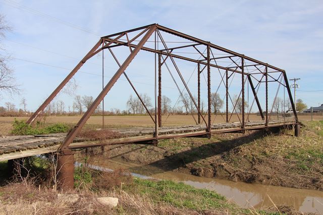
This bridge is a traditionally composed pin-connected Pratt through truss. The truss contains six panels, and there is a single stringer approach span. With a-frame portal bracing and no unusually distinctive details, the bridge stylistically dates to the later period of the pin-connected truss bridge era, and as such a construction date of c. 1905 seems appropriate. The more recent history of this bridge includes vehicular impact damage that bent a vertical member, and also appeared to result in a section of the bottom chord sagging somewhat. Following this damage, repairs were conducted, including but not limited to plates being welded to the damaged vertical member. These repairs made the bridge safe and in decent overall condition once again. With its attractive appearance and historic value as a surviving representative example of a once-common structure type, as well as carrying traffic on a road with a low average daily traffic of thirty, this bridge deserves to be preserved
![]()
![]()
![]()
Coordinates (Latitude, Longitude):
Search For Additional Bridge Listings:
Bridgehunter.com: View listed bridges within 0.5 miles (0.8 kilometers) of this bridge.
Bridgehunter.com: View listed bridges within 10 miles (16 kilometers) of this bridge.
Additional Maps:
Google Streetview (If Available)
GeoHack (Additional Links and Coordinates)
Apple Maps (Via DuckDuckGo Search)
Apple Maps (Apple devices only)
Android: Open Location In Your Map or GPS App
Flickr Gallery (Find Nearby Photos)
Wikimedia Commons (Find Nearby Photos)
Directions Via Sygic For Android
Directions Via Sygic For iOS and Android Dolphin Browser
USGS National Map (United States Only)
Historical USGS Topo Maps (United States Only)
Historic Aerials (United States Only)
CalTopo Maps (United States Only)

© Copyright 2003-2024, HistoricBridges.org. All Rights Reserved. Disclaimer: HistoricBridges.org is a volunteer group of private citizens. HistoricBridges.org is NOT a government agency, does not represent or work with any governmental agencies, nor is it in any way associated with any government agency or any non-profit organization. While we strive for accuracy in our factual content, HistoricBridges.org offers no guarantee of accuracy. Information is provided "as is" without warranty of any kind, either expressed or implied. Information could include technical inaccuracies or errors of omission. Opinions and commentary are the opinions of the respective HistoricBridges.org member who made them and do not necessarily represent the views of anyone else, including any outside photographers whose images may appear on the page in which the commentary appears. HistoricBridges.org does not bear any responsibility for any consequences resulting from the use of this or any other HistoricBridges.org information. Owners and users of bridges have the responsibility of correctly following all applicable laws, rules, and regulations, regardless of any HistoricBridges.org information.
![]()