

View Information About HSR Ratings

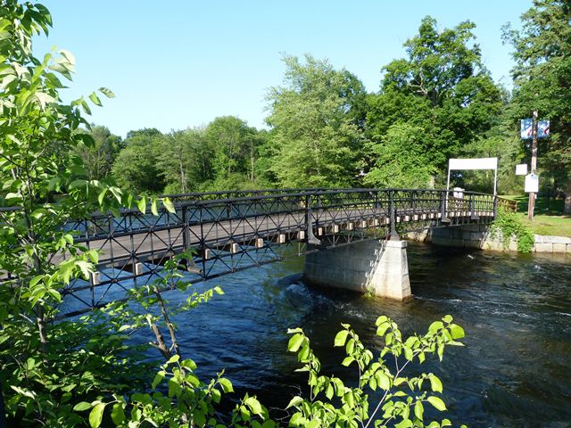
This bridge, constructed in 1881 with cast iron compression members, is a very late example of a truss bridge with cast iron compression members. Cast iron was used in bridge construction in the United States mostly from the 1840s through the early 1870s. It quickly gave way to wrought iron, which already was usually used for tension members, since brittle cast iron breaks under tension. Despite being a late example, this bridge is nationally significant as one of the few remaining examples of cast iron bridges in the United States. Additionally, like many cast iron bridges, it displays unique patented design details. In this case, the unique detail is the truss configuration, the only known surviving example of its type. The truss configuration was patented by Lucius E. Truesdell in 1859. Apparently, some examples of a span length longer than the Tilton bridge were built soon after in the Midwest, but soon collapsed under heavy loads, demonstrating that the Truesdell truss was destined to become one of many mid-1800s experiments in bridge design that quickly faded into memory. However, the Tilton Bridge was an exception. Albert D. Briggs, who had been an agent for Truesdell truss bridges, was able to attract the interest of Charles Tilton, who was the grandson of the founder of Tilton, and was using his wealth to create a park on this island. In 1881, Briggs constructed a Truesdell truss that has stood the test of time and remains today in good condition. The short spans seen in this bridge appear to make up for the shortcomings in the truss configuration that led to collapse in the earlier examples. The bridge was likely erected on-site by J. R. Smith of Springfield, Massachusetts.
Be sure to view the National Register Nomination link at the top of this narrative. The extensive nomination documentation provides a detailed history of the bridge.
![]()
![]()
![]()
Coordinates (Latitude, Longitude):
Search For Additional Bridge Listings:
Bridgehunter.com: View listed bridges within 0.5 miles (0.8 kilometers) of this bridge.
Bridgehunter.com: View listed bridges within 10 miles (16 kilometers) of this bridge.
Additional Maps:
Google Streetview (If Available)
GeoHack (Additional Links and Coordinates)
Apple Maps (Via DuckDuckGo Search)
Apple Maps (Apple devices only)
Android: Open Location In Your Map or GPS App
Flickr Gallery (Find Nearby Photos)
Wikimedia Commons (Find Nearby Photos)
Directions Via Sygic For Android
Directions Via Sygic For iOS and Android Dolphin Browser
USGS National Map (United States Only)
Historical USGS Topo Maps (United States Only)
Historic Aerials (United States Only)
CalTopo Maps (United States Only)

© Copyright 2003-2025, HistoricBridges.org. All Rights Reserved. Disclaimer: HistoricBridges.org is a volunteer group of private citizens. HistoricBridges.org is NOT a government agency, does not represent or work with any governmental agencies, nor is it in any way associated with any government agency or any non-profit organization. While we strive for accuracy in our factual content, HistoricBridges.org offers no guarantee of accuracy. Information is provided "as is" without warranty of any kind, either expressed or implied. Information could include technical inaccuracies or errors of omission. Opinions and commentary are the opinions of the respective HistoricBridges.org member who made them and do not necessarily represent the views of anyone else, including any outside photographers whose images may appear on the page in which the commentary appears. HistoricBridges.org does not bear any responsibility for any consequences resulting from the use of this or any other HistoricBridges.org information. Owners and users of bridges have the responsibility of correctly following all applicable laws, rules, and regulations, regardless of any HistoricBridges.org information.
![]()