

View Information About HSR Ratings
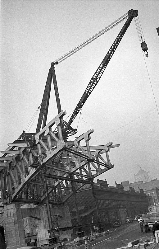
Above: Historical photo showing bridge construction.

Above: Historical photo showing bridge construction.
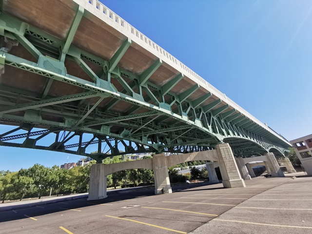
Information and Findings From Ohio's Historic Bridge InventorySetting/Context The viaduct carries 4 lanes and sidewalks of Columbia Parkway over city streets, parking lots, and IR 471 in central Cincinnati. The bridge, which has a vertical profile and is built on a horizontal curve, brings the parkway from the ridge below the Mt. Adams neighborhood (east end of viaduct) down to grade in downtown Cincinnati (west end of viaduct.) The setting is an urban mix of ca. 1900-1930 commercial buildings and warehouses to the south of the viaduct to modern high-rise buildings at the viaduct's west end. Columbia Parkway: "When the city began construction of Columbia Parkway in the 1930s, it intended that the project would eliminate deteriorating housing, create a scenic environment for motorists, and provide an arterial highway to carry the growing volume of commuter traffic from the eastern suburbs into the central city. To certain extent, these goals were achieved. A considerable number of aging homes were demolished and replaced by green space and a widened roadway. The drive along the parkway offers spectacular views of the Ohio River and Kentucky hills, provided the trees and underbrush have been trimmed. More than 50,000 vehicles per day travel the parkway, although they are slowed by congestion and stop lights in the Columbia business district. But in addition, the road has had considerable impact on the neighborhoods through which it passes, creating a barrier between sections of what were once part of the same community. In the first half of the nineteenth century, a series of unconnected strips of dirt road was all that occupied the path that the parkway now follows. Vehicles traveling to Cincinnati from eastern communities used Eastern Avenue, which passed through the commercial, residential, and industrial centers of the East End. In the late 1860s, work began on connecting these bits of road on the ledge above Eastern Avenue into a single street called Columbia Avenue. This road was to tie the downtown to the northern part of Columbia where Joseph Longworth had established a new subdivision for upper income homebuyers. But Columbia Avenue remained a secondary road, and most travelers still used Eastern Avenue. As early as 1907, city government considered turning the road into a parkway widening it and creating green space along the route. The 1907 comprehensive city park plan proposed connecting Cincinnati to Columbia Park (Alms Park) and Red Bank Park (Ault Park). The need for such a road became greater during the 1920s as the population of the eastern suburbs rapidly expanded and cars became more common. City officials also envisioned the parkway as a means of bringing Lunken Airport within a fifteen-minute drive of downtown. Work on the road began in 1929-1930, and the first section from Kemper Lane to Torrence Road was completed by 1931. Continuation of the road to Linwood Avenue was made possible by funding assistance from the federal Public Works Administration, and the entire parkway was opened in 1938. By 1941, more than 30,000 cars traveled Columbia Parkway each day, but the road was only a qualified success. More than one hundred buildings, mostly old frame houses in Fulton and Pendleton, had been demolished. But in the Columbia area, the parkway route passed through a small commercial district that city officials did not want to destroy. This created a bottleneck that was not improved when traffic lights were installed to reduce the disturbing number of accidents long that stretch of the parkway. Within twenty years of its completion, Columbia Parkway was widely regarded as inadequate by city planners and motorists. By the late 1950s, more than 60,000 cars per day passed over the parkway; it was simply overcrowded. In 1962, the road was extended from Linwood Avenue to the Village of Fairfax, adding even more traffic and eliminating a large number of Linwood's most attractive and historically significant homes. East End residents actively opposed an additional widening and rerouting plan that would have eliminated some 200 houses and businesses. Even after new freeways were completed in the mid-1970s and some of the parkway's traffic volume was reduced, problems remained. The business district bottleneck still existed, accidents were still common, and periodic mudslides hindered traffic flow and damaged the road itself. The small commercial district between Tusculum and Delta Avenues suffered from a lack of parking and heavy traffic that limited access for customers. At the same time, the business area underwent something of revitalization as new enterprises moved there, including the Precinct Restaurant in the former Sixth District Police Station and an auction house in the old Yeatman Masonic Lodge. Today, although a drive along Columbia Parkway is certainly more pleasant than it was twenty years ago, the road is still not the pleasing boulevard that park planners envisioned in 1907." From the Bicentennial Guide to Greater Cincinnati, published by the Cincinnati Historical Society, 1988. http://www.columbiatusculum.org/EastEndHistory.pdf Physical Description The skewed, 17 span, 1,659'-long viaduct is composed of 8 truss spans and 9 girder-floorbeam spans. The truss spans are continuous, rivet-connected Pratt deck trusses with curved bottom chords with the greatest depth over the piers. There is a four-span continuous unit flanked by 2-span continuous units. The trusses are composed of built-up members for the chords and verticals. The diagonals are rolled I sections. The trusses have angle lateral bracing. Rolled floorbeams support a concrete deck with cantilevered section. The concrete balustrades are in the Moderne-style and are articulated by posts that extend into vertically scored pylons at the main truss spans. The bridge is supported on 3-column reinforced-concrete bents with arched struts, vertical scoring, and chamfered corners. At either end of the viaduct the approach roadways have concrete retaining walls with pilasters. Integrity The bridge retains integrity of original design. Summary of Significance The continuous Pratt deck truss bridge was built in 1938 as part of a New Deal Public Works Administration project to complete Cincinnati's Columbia Parkway, a scenic parkway planned in 1907 that had evolved into one of the city's early expressway projects by the 1930s. The parkway had a significant impact on the development of Cincinnati's east side although its overall design did not well accommodate later increases in traffic and was not considered an engineering success (see context statement above). The bridge is historically significant for its association with the parkway project, forming its final vital link with downtown Cincinnati (Criterion A), as well as a technologically significant example of continuous truss design (Criterion C). The bridge is the oldest of eight continuous or continuous-cantilever truss highway bridges dating from 1938 to 1960 in the ODOT inventory (June 2009) [Note: the other seven are continuous-cantilever, that is the main spans have cantilever sections.]. The first major continuous truss bridge built in the United States was the 1916-17 Sciotoville Bridge of the C&O RR over the Ohio River at Sciotoville, Ohio. The difficulties associated with engineering analysis of continuous truss designs, however, limited their use until the 1930s when advances in engineering theory led to the development of professionally accepted methods of analysis and design. One of the significant advantages of continuous designs was that longer spans could be built using less material than comparable simple (non-continuous designs) since the loads could be spread across more than one span. The continuous design also reduces the number of expansion joints, an area of frequent maintenance and deterioration. A key design feature of long-span continuous designs was the use of variable depth trusses or beams with the greatest depth over the piers where the loads are greatest. This had the added aesthetic advantage of resulting in bridges with pleasingly arched lines. The 1938 Columbia Parkway bridge represents both the economical use of steel and the aesthetic advantages of the continuous design. Justification The bridge is one eight continuous or continuous-cantilever truss highway bridges dating from 1938 to 1960 in the ODOT inventory (June 2009). Based on its history, technology, and contexts), it has a moderate level of significance. Bridge Considered Historic By Survey: Yes |
![]()
![]()
![]()
Coordinates (Latitude, Longitude):
Search For Additional Bridge Listings:
Bridgehunter.com: View listed bridges within 0.5 miles (0.8 kilometers) of this bridge.
Bridgehunter.com: View listed bridges within 10 miles (16 kilometers) of this bridge.
Additional Maps:
Google Streetview (If Available)
GeoHack (Additional Links and Coordinates)
Apple Maps (Via DuckDuckGo Search)
Apple Maps (Apple devices only)
Android: Open Location In Your Map or GPS App
Flickr Gallery (Find Nearby Photos)
Wikimedia Commons (Find Nearby Photos)
Directions Via Sygic For Android
Directions Via Sygic For iOS and Android Dolphin Browser
USGS National Map (United States Only)
Historical USGS Topo Maps (United States Only)
Historic Aerials (United States Only)
CalTopo Maps (United States Only)

© Copyright 2003-2024, HistoricBridges.org. All Rights Reserved. Disclaimer: HistoricBridges.org is a volunteer group of private citizens. HistoricBridges.org is NOT a government agency, does not represent or work with any governmental agencies, nor is it in any way associated with any government agency or any non-profit organization. While we strive for accuracy in our factual content, HistoricBridges.org offers no guarantee of accuracy. Information is provided "as is" without warranty of any kind, either expressed or implied. Information could include technical inaccuracies or errors of omission. Opinions and commentary are the opinions of the respective HistoricBridges.org member who made them and do not necessarily represent the views of anyone else, including any outside photographers whose images may appear on the page in which the commentary appears. HistoricBridges.org does not bear any responsibility for any consequences resulting from the use of this or any other HistoricBridges.org information. Owners and users of bridges have the responsibility of correctly following all applicable laws, rules, and regulations, regardless of any HistoricBridges.org information.
![]()