

View Information About HSR Ratings
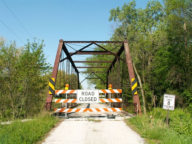
For a rural bridge, this was a fairly ornate bridge, since it features a number of decorative elements that do not occur on the average truss bridge. There are decorative curved steel elements that terminate the lattice railings at each end of the bridge. There are decorative finials on top of the end posts. And finally, even the relatively basic a-frame portal bracing has a decorative edging on the top section.
Structurally, the bridge is a pin connected Pratt through truss, and is composed of six panels. There is v-lacing under the top chord/end post and also on the vertical members. There are roller bearings at the east of of the bridge, which sits on stone abutments. The deck is wood with an asphalt wearing surface. Very little paint remains on the rusted structure. An eight ton weight limit was posted prior to the closure of this bridge to traffic.
There was another historic pony truss not too far from this bridge on New Rochester Road, but it was unfortunately demolished by the time HistoricBridges.org got to Wood County in 2006. However, Rick McOmber took this photo of the bridge prior to demolition.
By 2009, the Kemner Road Bridge was also demolished, not for a replacement bridge, but just for the sake of annihilating a beautiful historic bridge. Wood County has a very poor record of historic bridge preservation.
![]()
![]()
![]()
This historic bridge has been demolished. This map is shown for reference purposes only.
Coordinates (Latitude, Longitude):
Search For Additional Bridge Listings:
Bridgehunter.com: View listed bridges within 0.5 miles (0.8 kilometers) of this bridge.
Bridgehunter.com: View listed bridges within 10 miles (16 kilometers) of this bridge.
Additional Maps:
Google Streetview (If Available)
GeoHack (Additional Links and Coordinates)
Apple Maps (Via DuckDuckGo Search)
Apple Maps (Apple devices only)
Android: Open Location In Your Map or GPS App
Flickr Gallery (Find Nearby Photos)
Wikimedia Commons (Find Nearby Photos)
Directions Via Sygic For Android
Directions Via Sygic For iOS and Android Dolphin Browser
USGS National Map (United States Only)
Historical USGS Topo Maps (United States Only)
Historic Aerials (United States Only)
CalTopo Maps (United States Only)

© Copyright 2003-2024, HistoricBridges.org. All Rights Reserved. Disclaimer: HistoricBridges.org is a volunteer group of private citizens. HistoricBridges.org is NOT a government agency, does not represent or work with any governmental agencies, nor is it in any way associated with any government agency or any non-profit organization. While we strive for accuracy in our factual content, HistoricBridges.org offers no guarantee of accuracy. Information is provided "as is" without warranty of any kind, either expressed or implied. Information could include technical inaccuracies or errors of omission. Opinions and commentary are the opinions of the respective HistoricBridges.org member who made them and do not necessarily represent the views of anyone else, including any outside photographers whose images may appear on the page in which the commentary appears. HistoricBridges.org does not bear any responsibility for any consequences resulting from the use of this or any other HistoricBridges.org information. Owners and users of bridges have the responsibility of correctly following all applicable laws, rules, and regulations, regardless of any HistoricBridges.org information.
![]()