

View Information About HSR Ratings

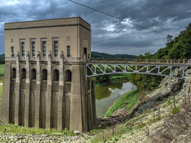
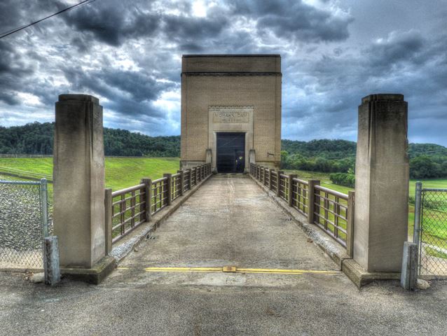
This bridge serves only as a maintencance access for a large utility building that is part of the Mowhawk dam. The polygonal deck truss is both uncommon and beautiful. Aesthetics were clearly a major consideration with both the bridge and the building. The truss design is aesthetically pleasing, while the railings are an Art Deco style. The building is also details with bas relief sculptures and other detailing that is also Art Deco in the general sense. Both bridge and building appear to be unaltered. Plaques for both the dam and bridge survive, Mount Vernon Bridge Company's plaque is mounted on the truss itself. As an off-system bridge, it was not evaluated by the Historic Bridge Inventory. A little culvert for the dam was evaluated, and that entry provides some basic history for the dam, but appears to be completely unaware of this structure which should be considered historically significant for its unusual design and embodyment of Art Deco detailing in a rural setting, unusual for this style of architecture.
Information and Findings For Nearby Dam Structure From Ohio's Historic Bridge Inventory (Taken From Nearby Culvert Description)Summary of Significance The culvert is part of Mohawk Dam that was started in April 1935 and was completed in September 1937. The dam was authorized by the Flood Control Act of 1938 and was built by the US Army Corps of Engineers along with 13 other dams in the Muskingum River watershed for flood control and water conservation. The dam was built across the right-of-way of the Walhonding Canal, which ran from Coshocton to Cavallo. It is one of several such flood control dams in the state and is not historically or technologically significant. The dam has always operated as a dry dam, holding back water only during a flood and releasing it slowly downstream. Bridge Considered Historic By Survey: No |
![]()
![]()
![]()
Coordinates (Latitude, Longitude):
Search For Additional Bridge Listings:
Bridgehunter.com: View listed bridges within 0.5 miles (0.8 kilometers) of this bridge.
Bridgehunter.com: View listed bridges within 10 miles (16 kilometers) of this bridge.
Additional Maps:
Google Streetview (If Available)
GeoHack (Additional Links and Coordinates)
Apple Maps (Via DuckDuckGo Search)
Apple Maps (Apple devices only)
Android: Open Location In Your Map or GPS App
Flickr Gallery (Find Nearby Photos)
Wikimedia Commons (Find Nearby Photos)
Directions Via Sygic For Android
Directions Via Sygic For iOS and Android Dolphin Browser
USGS National Map (United States Only)
Historical USGS Topo Maps (United States Only)
Historic Aerials (United States Only)
CalTopo Maps (United States Only)

© Copyright 2003-2025, HistoricBridges.org. All Rights Reserved. Disclaimer: HistoricBridges.org is a volunteer group of private citizens. HistoricBridges.org is NOT a government agency, does not represent or work with any governmental agencies, nor is it in any way associated with any government agency or any non-profit organization. While we strive for accuracy in our factual content, HistoricBridges.org offers no guarantee of accuracy. Information is provided "as is" without warranty of any kind, either expressed or implied. Information could include technical inaccuracies or errors of omission. Opinions and commentary are the opinions of the respective HistoricBridges.org member who made them and do not necessarily represent the views of anyone else, including any outside photographers whose images may appear on the page in which the commentary appears. HistoricBridges.org does not bear any responsibility for any consequences resulting from the use of this or any other HistoricBridges.org information. Owners and users of bridges have the responsibility of correctly following all applicable laws, rules, and regulations, regardless of any HistoricBridges.org information.
![]()