

View Information About HSR Ratings

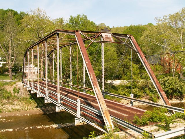
The bridge is a beautiful example of a pin connected truss bridge, specifically the camelback style, having five parts to its polygonal top chord/endpost. It was constructed in 1904. There is v-lacing on the vertical members and under the top chord. Original railings do not remain on the bridge, and have been replaced with modern Armco railings. The deck is currently a metal grate style. The abutments are stone with some concrete repair done to them. Cambria brands were found on the bridge. This bridge was in the 1950 "re-erected" according to a plaque on the bridge. Reportedly, this bridge was relocated from elsewhere to this location in 1950, where it was reused, replacing an old covered bridge. There are some alterations to the structure, particularly the replacement of the floor beams and the deck. The rest of the structure appears to have excellent historic integrity.
In more recent years, this bridge was bypassed by a modern bridge. However, it was not demolished, and was left standing where the bridge continues to be an attractive historic landmark for all to see and visit. The concept of leaving a historic bridge standing next to its replacement might seem like an obvious thing to do, but some states like Pennsylvania, and indeed even other counties in Ohio refuse to do this. Instead, these places waste money and destroy history by demolishing historic bridges that are not in the way of their replacement. This bridge shows that destruction can be avoided.
The Champion Bridge Company was in the bridge business in Ohio for a long time. This is an example of their impressive pin connected era work, having been built in 1904. They however continued to build truss bridges as late as 1964 in Preble County.
![]()
![]()
![]()
Coordinates (Latitude, Longitude):
Search For Additional Bridge Listings:
Bridgehunter.com: View listed bridges within 0.5 miles (0.8 kilometers) of this bridge.
Bridgehunter.com: View listed bridges within 10 miles (16 kilometers) of this bridge.
Additional Maps:
Google Streetview (If Available)
GeoHack (Additional Links and Coordinates)
Apple Maps (Via DuckDuckGo Search)
Apple Maps (Apple devices only)
Android: Open Location In Your Map or GPS App
Flickr Gallery (Find Nearby Photos)
Wikimedia Commons (Find Nearby Photos)
Directions Via Sygic For Android
Directions Via Sygic For iOS and Android Dolphin Browser
USGS National Map (United States Only)
Historical USGS Topo Maps (United States Only)
Historic Aerials (United States Only)
CalTopo Maps (United States Only)

© Copyright 2003-2025, HistoricBridges.org. All Rights Reserved. Disclaimer: HistoricBridges.org is a volunteer group of private citizens. HistoricBridges.org is NOT a government agency, does not represent or work with any governmental agencies, nor is it in any way associated with any government agency or any non-profit organization. While we strive for accuracy in our factual content, HistoricBridges.org offers no guarantee of accuracy. Information is provided "as is" without warranty of any kind, either expressed or implied. Information could include technical inaccuracies or errors of omission. Opinions and commentary are the opinions of the respective HistoricBridges.org member who made them and do not necessarily represent the views of anyone else, including any outside photographers whose images may appear on the page in which the commentary appears. HistoricBridges.org does not bear any responsibility for any consequences resulting from the use of this or any other HistoricBridges.org information. Owners and users of bridges have the responsibility of correctly following all applicable laws, rules, and regulations, regardless of any HistoricBridges.org information.
![]()