

View Information About HSR Ratings
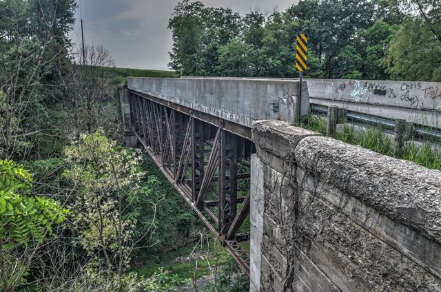
This is a 19th century railroad deck truss bridge that was relocated and reused as a highway overpass in 1919. The historic bridge inventory suggests a ca. 1890 construction date for the bridge which seems plausible. The deck of the bridge has a modern appearance to it, and does a good job of hiding the beautiful and largely unaltered trusses hidden under the roadway. The bridge is noted as the only pin-connected deck truss remaining on Ohio highways.
Information and Findings From Ohio's Historic Bridge InventorySetting/Context The bridge carries a 1 lane road over a rail line carried in a depressed section (cut). The setting is rural and sparsely developed. The approach roadway is on a curve, and the bridge is wider than the approach roadway. The rail line crossed by the bridge was established ca. 1845 by the Cleveland & Pittsburgh Railway (C&P). The C&P was incorporated in 1836 in the state of Ohio, but incorporation in Pennsylvania was delayed nearly a decade before construction began. The C&P's main line connected Pittsburgh to Cleveland by way of Rochester, Pa. and Steubenville, Oh., with branches to Bellaire and New Philadelphia, Ohio. The line was absorbed into the Pennsylvania RR system in 1871. About 1919, the Pennsylvania RR realigned and double-tracked the old C&P line for about 3 miles north of Summitville, Ohio. The original line had curved to the east following Brush Creek Fork through the village of Millport. The new straighter alignment adopted in 1919 cut through the hills west of Millport, rejoining the original line near the Columbiana-Carroll county line at McKaig Road. The Columbiana Board of County Commissioners had previously authorized the railroad to change its grade and that of certain highways on Aug. 27, 1917. As a result, the railroad was obliged to build a bridge where its new cut intersected Willard Road, a previously existing county road. The deck truss is the bridge placed by the railroad about 1919. Physical Description The 1 span, 148'-long, pin-connected Pratt deck truss bridge is supported on concrete abutments. The truss is heavily built, more typical of railroad loadings than highway loadings of the time. It has multiple sets of eyebars for the lower chords and diagonals. The compression members are built-up sections of channels with lacing and battens. The upper chords support a concrete deck with paneled concrete parapets. Integrity Concrete parapets are deteriorated. Concrete abutments are spalled. Truss was relocated here about 1919. Summary of Significance The steel deck truss is historically and technologically significant as the only pin-connected deck truss bridge remaining in the state. It was originally a rail-carrying bridge designed for railroad loadings. The style/design of the truss dates ca. 1890, but it was not placed here until ca. 1919. This reflects the typical challenge that railroads faced as increasing steam locomotive weights drove the evolution of truss bridge design promoting innovation and frequent replacement of bridges to meet the increased loads. Pin-connected truss bridges, because of the problems associated with stress reversals under heavy loads, became a particular concern, promoting the transition from pinned to riveted connections starting the mid 1890s to 1900s. Older truss bridges were not uncommonly re-used as highway overpasses where loads were not so great. The original location of this bridge is unknown. According to county atlases and records, the bridge was placed ca. 1919 by the Pennsylvania RR as part of a project to improve its line that served as a freight route between the upper Ohio Valley and Cleveland. The construction of the cut to maintain a steady grade necessitated the construction of an overpass where the line intersected Willard Road northwest of Millport. Pratt trusses were undoubtedly the most popular truss design of the last quarter of the 19th century and continued to be built into the 20th century, although eventually superseded in popularity by Warren trusses. The design, which initially was a combination of wood compression and iron tension members, was patented in 1844 by Thomas & Caleb Pratt. The great advantage of the Pratt over other designs was the relative ease of calculating the distribution of stresses. More significantly, it translated well into an all-metal design in lengths of less than 200'. Significant surviving examples of all-metal Pratt trusses mostly date to the last quarter of the 19th century, and they are found with thru, pony, and the less common bedstead configuration. Prior to about 1890, a variety of panel point connections were in widespread use (including bolts, cast-iron pieces, and pins), but engineering opinion was coalescing around pins as the most efficient and constructible. Many of the connection details were proprietary and associated with individual builders or companies, and thus earlier examples are generally taken to be technologically significant in showing the evolution of the design. Later post-1890 Pratt trusses show a progression toward less variation in their details such that by 1900 the design was quite formulaic with few significant differences between the designs of various builders. This marked the end of the pin-connected Pratt's technological evolution and, in fact, it was soon waning and eclipsed in the highway bridge market by more rigid, rivet-connected truss designs, particularly the Warren but also riveted Pratts. The transition to riveted connections, which happened even earlier with railroads than highways, was in no small part due to concerns about stress reversals at the pins under heavier loads and improvements in pneumatic field riveting equipment in the early 1900s. Justification The bridge is one of 57 extant pin-connected truss bridges dating from 1874 for pony trusses and 1876 for thru trusses. Twenty six predate 1888 and represent the era of experimentation that evolved into standardized designs by about 1888. This example has moderate significance. Bridge Considered Historic By Survey: Yes |
![]()
![]()
![]()
Coordinates (Latitude, Longitude):
Search For Additional Bridge Listings:
Bridgehunter.com: View listed bridges within 0.5 miles (0.8 kilometers) of this bridge.
Bridgehunter.com: View listed bridges within 10 miles (16 kilometers) of this bridge.
Additional Maps:
Google Streetview (If Available)
GeoHack (Additional Links and Coordinates)
Apple Maps (Via DuckDuckGo Search)
Apple Maps (Apple devices only)
Android: Open Location In Your Map or GPS App
Flickr Gallery (Find Nearby Photos)
Wikimedia Commons (Find Nearby Photos)
Directions Via Sygic For Android
Directions Via Sygic For iOS and Android Dolphin Browser
USGS National Map (United States Only)
Historical USGS Topo Maps (United States Only)
Historic Aerials (United States Only)
CalTopo Maps (United States Only)

© Copyright 2003-2025, HistoricBridges.org. All Rights Reserved. Disclaimer: HistoricBridges.org is a volunteer group of private citizens. HistoricBridges.org is NOT a government agency, does not represent or work with any governmental agencies, nor is it in any way associated with any government agency or any non-profit organization. While we strive for accuracy in our factual content, HistoricBridges.org offers no guarantee of accuracy. Information is provided "as is" without warranty of any kind, either expressed or implied. Information could include technical inaccuracies or errors of omission. Opinions and commentary are the opinions of the respective HistoricBridges.org member who made them and do not necessarily represent the views of anyone else, including any outside photographers whose images may appear on the page in which the commentary appears. HistoricBridges.org does not bear any responsibility for any consequences resulting from the use of this or any other HistoricBridges.org information. Owners and users of bridges have the responsibility of correctly following all applicable laws, rules, and regulations, regardless of any HistoricBridges.org information.
![]()