

View Information About HSR Ratings

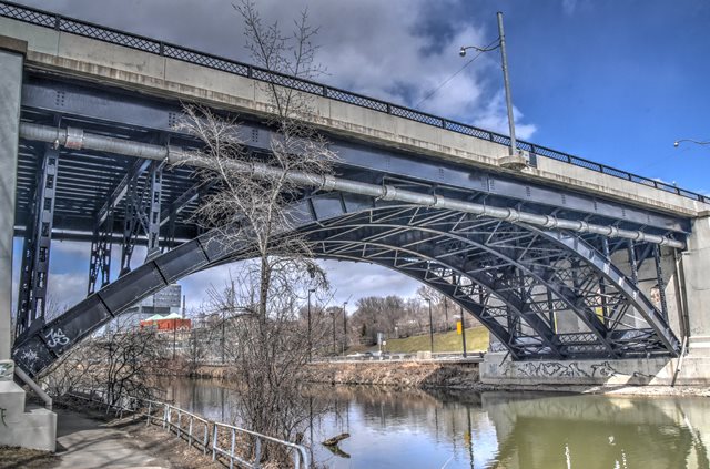
This bridge as originally designed, consisted, from west to east, of two deck plate girder spans, a deck arch span over the Don River, and finally two more deck plate girder spans. Today, the bridge has been altered from this design. The two eastern deck plate girder approach spans have been demolished and replaced with a single span steel stringer bridge, a change that was likely made to accommodate the Don Valley Parkway which now passes under this part of the bridge. The bridge has also been widened from its original design. An additional steel stringer added to both sides of the bridge alongside the remaining original spans supports a wider deck on top, which is also not original. Original ornamental railings have been lost from the original bridge as well. Despite these alterations, the bridge remains noteworthy for its steel deck arch span. Although Toronto has several examples of this structure type, steel deck arch bridges are rare elsewhere in Ontario. The previous bridge at this location was a four span Warren (no verticals) pony truss.


Above: Views of the previous bridge at this location.
This bridge is tagged with the following special condition(s): Unorganized Photos
![]()

![]()
![]()
![]()
![]()
Coordinates (Latitude, Longitude):
Search For Additional Bridge Listings:
Additional Maps:
Google Streetview (If Available)
GeoHack (Additional Links and Coordinates)
Apple Maps (Via DuckDuckGo Search)
Apple Maps (Apple devices only)
Android: Open Location In Your Map or GPS App
Flickr Gallery (Find Nearby Photos)
Wikimedia Commons (Find Nearby Photos)
Directions Via Sygic For Android
Directions Via Sygic For iOS and Android Dolphin Browser

© Copyright 2003-2024, HistoricBridges.org. All Rights Reserved. Disclaimer: HistoricBridges.org is a volunteer group of private citizens. HistoricBridges.org is NOT a government agency, does not represent or work with any governmental agencies, nor is it in any way associated with any government agency or any non-profit organization. While we strive for accuracy in our factual content, HistoricBridges.org offers no guarantee of accuracy. Information is provided "as is" without warranty of any kind, either expressed or implied. Information could include technical inaccuracies or errors of omission. Opinions and commentary are the opinions of the respective HistoricBridges.org member who made them and do not necessarily represent the views of anyone else, including any outside photographers whose images may appear on the page in which the commentary appears. HistoricBridges.org does not bear any responsibility for any consequences resulting from the use of this or any other HistoricBridges.org information. Owners and users of bridges have the responsibility of correctly following all applicable laws, rules, and regulations, regardless of any HistoricBridges.org information.
![]()