

View Information About HSR Ratings
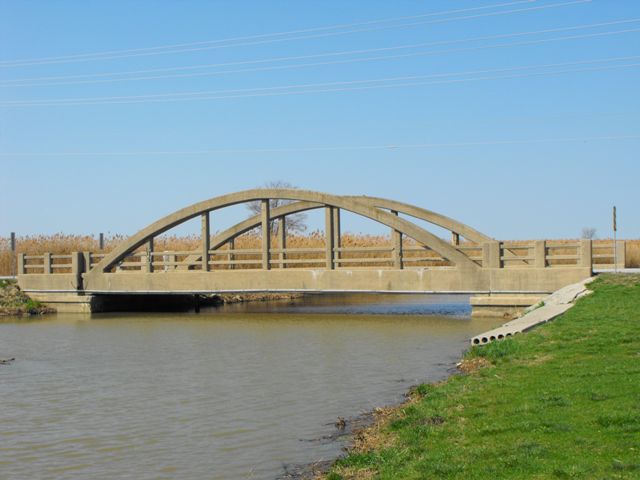
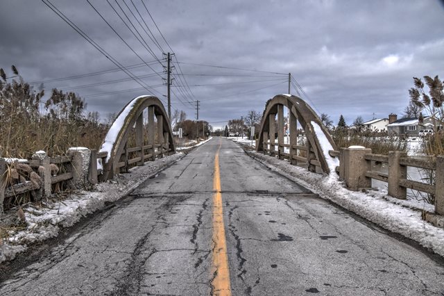
This bridge is the smaller of two beautiful concrete bowstring through arch bridges (often called rainbow arch bridges) in Essex County, which are nearby each other. Both bridges are unusual because they do not follow the standard plan seen many other Ontario rainbow arch bridges. This other more common standard plan includes more massive members and arches, and inset rectangles on the arch, and they also have simple concrete balustrade railings. In contrast, the two seen in Essex County contain no inset rectangles, very lightweight members, and their railings are concrete fence railings. Note that despite their extremely lightweight construction, they are not Marsh arches. Exposed reinforcing rods were observed inside the concrete and no evidence of solid built-up beams that would define a Marsh Arch were present.
The 2nd Concession Bridge carries two lanes of traffic and no sidewalk. The bridge appears to be unaltered from its original construction, and no evidence of a rehabilitation was observed. The only change to the original bridge was the application of asphalt on to of the original concrete deck. Overall, the bridge appears to be in fair condition, however there is severe spalling on some verticals and sections of railing. This spalling was of interest however because it did expose the reinforcing rods for the bridge which was useful in documenting this heritage bridge's construction. Simple round metal rods with no texturing appear to form the primary reinforcement. Smaller wires similar to barbed wire tie these rods together.
The time to rehabilitate this bridge is now. In its current condition, the bridge could be rehabilitated to the same condition that the nearby River Canard Bridge. However, as time goes by and the bridge is not rehabilitated, the loss of original bridge material will increase, as will the cost of rehabilitating the bridge.
The 2nd Concession Road Bridge should be considered an Ontario heritage bridge because the bridge is historically and technologically significant. It is an example of a rainbow arch bridge that follows a different design than most rainbow arch bridges in Ontario. The bridge also retains an excellent degree of historic integrity, and is in a condition where the bridge could be restored to correct the deterioration noted on some of the members. Finally, the bridge is noteworthy because together with the nearby River Canard Bridge it forms a small "group" of heritage structures of similar design yet each has a different span length and one has a sidewalk while the other does not. The two structure compliment each other and increase the interpretive value of the heritage structures. They make a good comparison to each other, and they demonstrate that although their design did not follow the more common standard plan for rainbow arch bridges in Ontario, the design was not one of a kind.
This bridge is tagged with the following special condition(s): Unorganized Photos
![]()
![]()
![]()

![]()
![]()
![]()
This historic bridge has been demolished. This map is shown for reference purposes only.
Coordinates (Latitude, Longitude):
Search For Additional Bridge Listings:
Additional Maps:
Google Streetview (If Available)
GeoHack (Additional Links and Coordinates)
Apple Maps (Via DuckDuckGo Search)
Apple Maps (Apple devices only)
Android: Open Location In Your Map or GPS App
Flickr Gallery (Find Nearby Photos)
Wikimedia Commons (Find Nearby Photos)
Directions Via Sygic For Android
Directions Via Sygic For iOS and Android Dolphin Browser

© Copyright 2003-2025, HistoricBridges.org. All Rights Reserved. Disclaimer: HistoricBridges.org is a volunteer group of private citizens. HistoricBridges.org is NOT a government agency, does not represent or work with any governmental agencies, nor is it in any way associated with any government agency or any non-profit organization. While we strive for accuracy in our factual content, HistoricBridges.org offers no guarantee of accuracy. Information is provided "as is" without warranty of any kind, either expressed or implied. Information could include technical inaccuracies or errors of omission. Opinions and commentary are the opinions of the respective HistoricBridges.org member who made them and do not necessarily represent the views of anyone else, including any outside photographers whose images may appear on the page in which the commentary appears. HistoricBridges.org does not bear any responsibility for any consequences resulting from the use of this or any other HistoricBridges.org information. Owners and users of bridges have the responsibility of correctly following all applicable laws, rules, and regulations, regardless of any HistoricBridges.org information.
![]()