

View Information About HSR Ratings
2019 Update: Mike Downey contacted HistoricBridges.org and reports that a rehabilitation of this bridge is complete. The bridge opened on March 31, 2019 after being closed for three months for repairs. The entire deck was replaced.

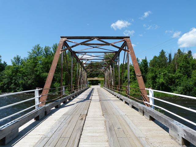
This bridge is a nice looking example of a riveted truss bridge and it contributes to the beauty of the river and the heritage of the setting, which includes a swing bridge a short distance away. This bridge is traditionally composed and was built by the Dominion Bridge Company, which was one of the largest bridge building companies in Canada. This bridge was built ca. 1900. In 1904, a flood destroyed part of the substructure and caused one end of the bridge to drop. The truss was not demolished however and was placed upon a reconstructed substructure.
This bridge was closed and at risk for demolition for a time. However, local residents formed the Friends of Andrewsville Bridge and successfully saved the bridge from demolition. Instead of demolition, some minor repairs were made and headache bars were placed on the approaches to the bridge to prevent trucks from disobeying the weight limit for the bridge. This bridge is therefore noteworthy as one of the few heritage truss bridges in Ontario to have ever been saved from demolition. Hopefully the bridge will inspire preservation of additional bridges. The headache bars are a great way to enforce weight limits, since trucks are unable to pass under the low clearance of the headache bar. The repairs made to the bridge appear to be minor in nature. Of note, some of the battens on the diagonals were replaced. The replaced steel was painted bright yellow for unknown reasons.

![]()
![]()
![]()

![]()
Coordinates (Latitude, Longitude):
Search For Additional Bridge Listings:
Additional Maps:
Google Streetview (If Available)
GeoHack (Additional Links and Coordinates)
Apple Maps (Via DuckDuckGo Search)
Apple Maps (Apple devices only)
Android: Open Location In Your Map or GPS App
Flickr Gallery (Find Nearby Photos)
Wikimedia Commons (Find Nearby Photos)
Directions Via Sygic For Android
Directions Via Sygic For iOS and Android Dolphin Browser

© Copyright 2003-2025, HistoricBridges.org. All Rights Reserved. Disclaimer: HistoricBridges.org is a volunteer group of private citizens. HistoricBridges.org is NOT a government agency, does not represent or work with any governmental agencies, nor is it in any way associated with any government agency or any non-profit organization. While we strive for accuracy in our factual content, HistoricBridges.org offers no guarantee of accuracy. Information is provided "as is" without warranty of any kind, either expressed or implied. Information could include technical inaccuracies or errors of omission. Opinions and commentary are the opinions of the respective HistoricBridges.org member who made them and do not necessarily represent the views of anyone else, including any outside photographers whose images may appear on the page in which the commentary appears. HistoricBridges.org does not bear any responsibility for any consequences resulting from the use of this or any other HistoricBridges.org information. Owners and users of bridges have the responsibility of correctly following all applicable laws, rules, and regulations, regardless of any HistoricBridges.org information.
![]()