

View Information About HSR Ratings
This bridge is noteworthy as an example of the Rochester Bridge and Construction Company. Few bridges built by this company remain. By the way, the Historic Bridge Inventory's finding that there are 16 pin connected truss bridges in the county is far outdated, as the number is much smaller and shrinking rapidly.
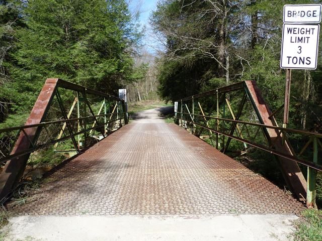
Information and Findings From Pennsylvania's Historic Bridge InventoryDiscussion of Bridge The bridge carries 1 lane of an unimproved road over a stream in a sparsely developed, forested setting. Discussion of Surrounding Area The 1904, pin connected, 61'-long, Pratt pony truss bridge with the floor beams above the lower chords is supported on ashlar abutments with flared wingwalls. The bridge has built up upper chords, and verticals. The lower chords and diagonals are eye bars. The bridge is a late example of a common technology and it has no distinctive details. Sixteen pin connected truss bridges ranging in date from 1880 to 1904 remain in the county. Earlier examples represent the significance of the technology. Bridge Considered Historic By Survey: No |
![]()
![]()
![]()

![]()
Coordinates (Latitude, Longitude):
Search For Additional Bridge Listings:
Bridgehunter.com: View listed bridges within 0.5 miles (0.8 kilometers) of this bridge.
Bridgehunter.com: View listed bridges within 10 miles (16 kilometers) of this bridge.
Additional Maps:
Google Streetview (If Available)
GeoHack (Additional Links and Coordinates)
Apple Maps (Via DuckDuckGo Search)
Apple Maps (Apple devices only)
Android: Open Location In Your Map or GPS App
Flickr Gallery (Find Nearby Photos)
Wikimedia Commons (Find Nearby Photos)
Directions Via Sygic For Android
Directions Via Sygic For iOS and Android Dolphin Browser
USGS National Map (United States Only)
Historical USGS Topo Maps (United States Only)
Historic Aerials (United States Only)
CalTopo Maps (United States Only)

© Copyright 2003-2024, HistoricBridges.org. All Rights Reserved. Disclaimer: HistoricBridges.org is a volunteer group of private citizens. HistoricBridges.org is NOT a government agency, does not represent or work with any governmental agencies, nor is it in any way associated with any government agency or any non-profit organization. While we strive for accuracy in our factual content, HistoricBridges.org offers no guarantee of accuracy. Information is provided "as is" without warranty of any kind, either expressed or implied. Information could include technical inaccuracies or errors of omission. Opinions and commentary are the opinions of the respective HistoricBridges.org member who made them and do not necessarily represent the views of anyone else, including any outside photographers whose images may appear on the page in which the commentary appears. HistoricBridges.org does not bear any responsibility for any consequences resulting from the use of this or any other HistoricBridges.org information. Owners and users of bridges have the responsibility of correctly following all applicable laws, rules, and regulations, regardless of any HistoricBridges.org information.
![]()