

View Information About HSR Ratings


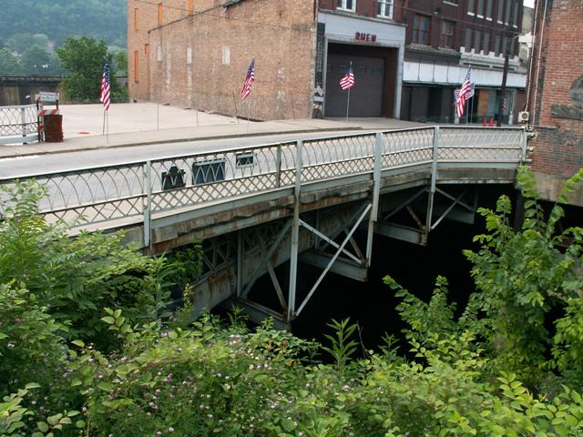
In the United States, this is as old as metal bridges get! Not only is it the oldest iron bridge in the United States, it was the first cast iron bridge ever built in the country. Unbelievably, this bridge is over 170 years old yet it remains open to motorized traffic today (a concept this bridge's builders wouldn't have imagined in their wildest dreams) and the bridge carries this traffic even without excessive restrictions, despite the fact that since 1923 the bridge has carried a wider deck than the bridge was originally designed for! This is a testimony to the quality of construction and the extremely pure quality of the iron used to fabricate the arch. The age and continuing function of this historic bridge puts modern engineering and construction to shame. Many modern bridges have failed to last even 70 years, and engineers today tend to be proud when they try to claim their new bridges will last 100 years.
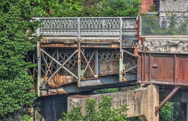
As you seem to find with the extremely old metal bridges like the famous Firth of Forth Bridge in Scotland, tubular-shaped elements were used on the Market Street Bridge, in particular the main arch. The spandrel design and other original bracing for the bridge are star-shaped elements. The layout of the arch and the lattice spandrel design appears to have been influenced by British cast iron bridges existing and being built in Great Britain when this bridge was built.
As if its age was not enough significance, this bridge is associated with a historic highway. This bridge was built to carry the famous Cumberland Road, which was later renamed to the National Road. As the latter name implies, this was a significant corridor of travel in the earlier years of the United State's development. If people call Route 66 the mother road, than perhaps this road should be called the father road. The National Road is one of the roads that got people out to the Midwest (where Route 66 begins) in the first place. Near the bridge today, there is historic National Road signage for people wishing to travel the closest approximation to the route. In general US-40 also follows the path of the National Road, although the exact alignment is a bit different in some places. For instance, Market Street no longer carries US-40, although it once did.

This bridge is one of the most frustrating bridges ever to photograph. A long time ago, indeed before the 1920 expansion of this bridge took place, someone built a building so large that part of it sits on supports right over Dunlaps Creek, right beside the bridge! Similarly, a foundation of another building continues to block the view of the bridge on the other side. You can't even see the whole bridge as a result!
This bridge is a perfect example of how a historic bridge can indeed support 21st century traffic. This bridge was widened in 1920 to the current 37 foot width present today. This modification is so old, it itself is essentially historic. The beautiful railings are from that 1920 modification, although some panels have been replaced with newer replicas in recent years. In the above photo, the panel closest to where I am standing, the front left panel, is one of the replaced panels. The other panels on that closest side to me are all original.
There is some interest in removing the unused foundation blocking the bridge and also creating a park by the bridge to facilitate viewing of the bridge. HistoricBridges.org strongly supports this proposal. This is one of the most important structures in the United States, and it deserves to be accessible.
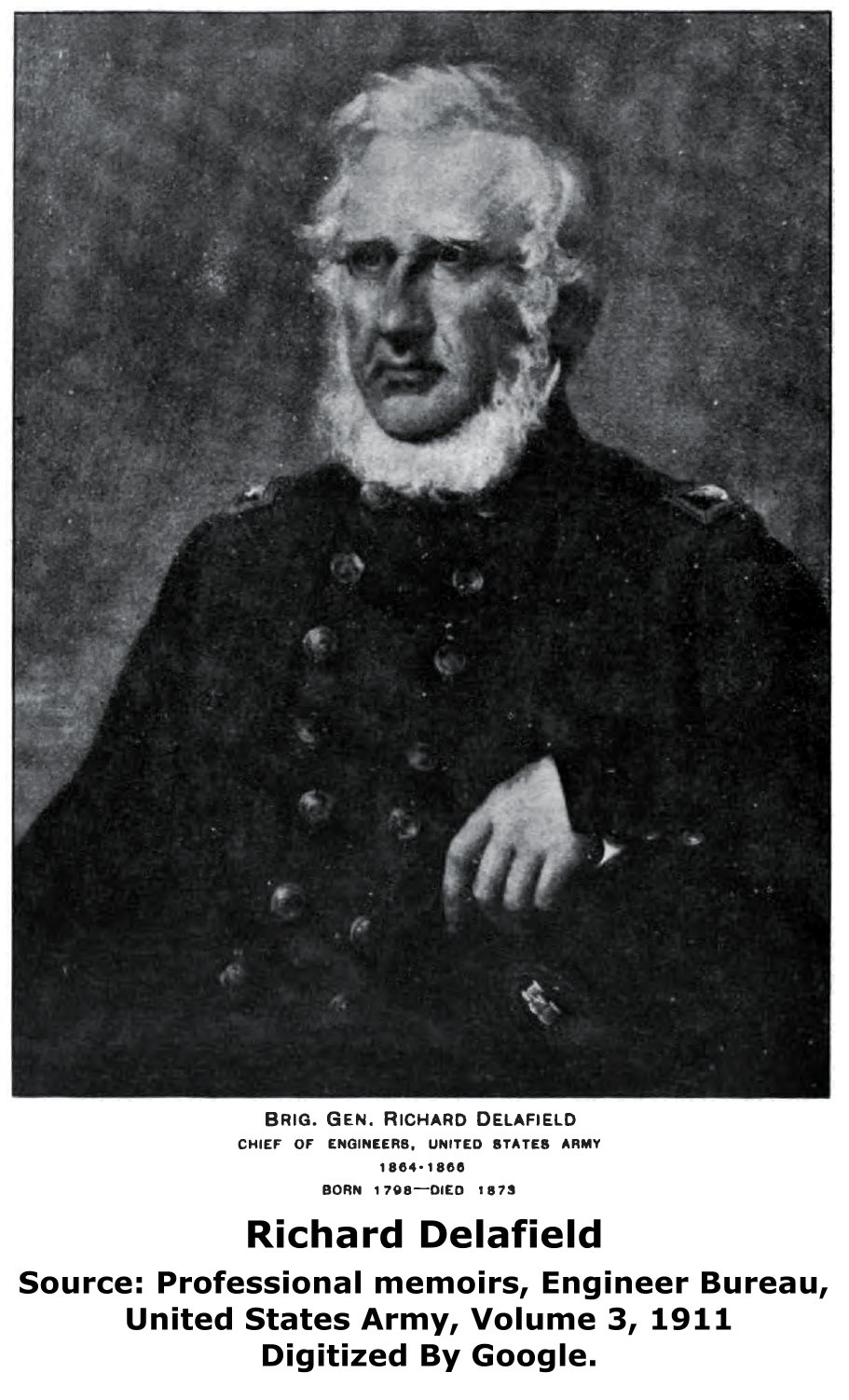
William Searight was described as "one of the contractors who built the iron bridge over the mouth of Dunlap's creek..." It is currently not known who some of the other contractors might have been. His portrait is shown in the image to the left. A book titled Biographical and portrait cyclopedia of Fayette County, Pennsylvania (1889) contains a biography of John Herbertson who is described as having designed and supervised the construction of the bridge. Historic American Engineering Record comments that John Snowden also worked with Herbertson to design the bridge. Randle Dearth is listed as the builder of the bridge's stone abutments in a book Recollections of James Guthrie Johnston compiled and edited by William H. Cooke. and published in 1929.
This bridge is tagged with the following special condition(s): Arch Lattice Railing
![]()
![]()
![]()
![]()
Coordinates (Latitude, Longitude):
Search For Additional Bridge Listings:
Bridgehunter.com: View listed bridges within 0.5 miles (0.8 kilometers) of this bridge.
Bridgehunter.com: View listed bridges within 10 miles (16 kilometers) of this bridge.
Additional Maps:
Google Streetview (If Available)
GeoHack (Additional Links and Coordinates)
Apple Maps (Via DuckDuckGo Search)
Apple Maps (Apple devices only)
Android: Open Location In Your Map or GPS App
Flickr Gallery (Find Nearby Photos)
Wikimedia Commons (Find Nearby Photos)
Directions Via Sygic For Android
Directions Via Sygic For iOS and Android Dolphin Browser
USGS National Map (United States Only)
Historical USGS Topo Maps (United States Only)
Historic Aerials (United States Only)
CalTopo Maps (United States Only)

© Copyright 2003-2024, HistoricBridges.org. All Rights Reserved. Disclaimer: HistoricBridges.org is a volunteer group of private citizens. HistoricBridges.org is NOT a government agency, does not represent or work with any governmental agencies, nor is it in any way associated with any government agency or any non-profit organization. While we strive for accuracy in our factual content, HistoricBridges.org offers no guarantee of accuracy. Information is provided "as is" without warranty of any kind, either expressed or implied. Information could include technical inaccuracies or errors of omission. Opinions and commentary are the opinions of the respective HistoricBridges.org member who made them and do not necessarily represent the views of anyone else, including any outside photographers whose images may appear on the page in which the commentary appears. HistoricBridges.org does not bear any responsibility for any consequences resulting from the use of this or any other HistoricBridges.org information. Owners and users of bridges have the responsibility of correctly following all applicable laws, rules, and regulations, regardless of any HistoricBridges.org information.
![]()