

View Information About HSR Ratings
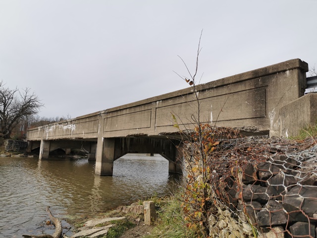
This is a rare example of a concrete through girder in western Pennsylvania. With a 1943 construction date it is also a very late example of a concrete through girder bridge. It may have been a solution to steel shortages due to World War II.
Information and Findings From Pennsylvania's Historic Bridge InventoryDiscussion of Bridge The 3-span continuous, 143'-long, reinforced concrete through girder bridge was built in 1943 during World War II, which is why it is a reinforced concrete rather than a steel bridge. It is supported on a concrete substructure. The center span is 60' long and the two approach spans are 41' long. It has paneled parapets. The bridge is not related to any military facility, so it is not associated with the war effort. Neither the bridge nor its setting is historically or technologically significant. Discussion of Surrounding Area The bridge carries a two-lane road over a stream in an area dominated by a mix of mid- to late-20th century residential and commercial development. The area does not appear to have historic district potential. Bridge Considered Historic By Survey: No |
![]()
![]()
![]()
This historic bridge has been demolished. This map is shown for reference purposes only.
Coordinates (Latitude, Longitude):
Search For Additional Bridge Listings:
Bridgehunter.com: View listed bridges within 0.5 miles (0.8 kilometers) of this bridge.
Bridgehunter.com: View listed bridges within 10 miles (16 kilometers) of this bridge.
Additional Maps:
Google Streetview (If Available)
GeoHack (Additional Links and Coordinates)
Apple Maps (Via DuckDuckGo Search)
Apple Maps (Apple devices only)
Android: Open Location In Your Map or GPS App
Flickr Gallery (Find Nearby Photos)
Wikimedia Commons (Find Nearby Photos)
Directions Via Sygic For Android
Directions Via Sygic For iOS and Android Dolphin Browser
USGS National Map (United States Only)
Historical USGS Topo Maps (United States Only)
Historic Aerials (United States Only)
CalTopo Maps (United States Only)

© Copyright 2003-2024, HistoricBridges.org. All Rights Reserved. Disclaimer: HistoricBridges.org is a volunteer group of private citizens. HistoricBridges.org is NOT a government agency, does not represent or work with any governmental agencies, nor is it in any way associated with any government agency or any non-profit organization. While we strive for accuracy in our factual content, HistoricBridges.org offers no guarantee of accuracy. Information is provided "as is" without warranty of any kind, either expressed or implied. Information could include technical inaccuracies or errors of omission. Opinions and commentary are the opinions of the respective HistoricBridges.org member who made them and do not necessarily represent the views of anyone else, including any outside photographers whose images may appear on the page in which the commentary appears. HistoricBridges.org does not bear any responsibility for any consequences resulting from the use of this or any other HistoricBridges.org information. Owners and users of bridges have the responsibility of correctly following all applicable laws, rules, and regulations, regardless of any HistoricBridges.org information.
![]()