


View Information About HSR Ratings
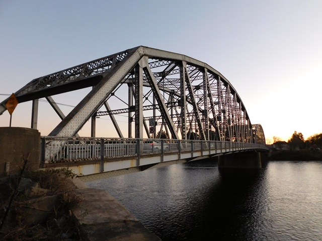
This bridge is noted for its large 325 foot main spans and extensive use of v-lacing and lattice on its members. The span length is long among surviving metal truss bridges today thanks to demolition of other similarly long bridges. The bridge retains excellent historic integrity. It is noted for its wide 44 foot roadway as well.

Above: Previous bridge at this location. Built 1903 by Owego Bridge Company of Owego, New York.

Above: Previous bridge at this location. Built 1903 by Owego Bridge Company of Owego, New York.

Above: Earlier bridge at this location.
Information and Findings From Pennsylvania's Historic Bridge InventoryDiscussion of Bridge The 2 span, 659'-long, riveted, steel Parker through truss bridge built in 1939 is supported on a reinforced concrete substructure. It is traditionally composed with built up members and was designed for high load capacity. The bridge has no innovative or distinctive details. It is an example of a type and design that had been used since ca. 1900, and it is not historically or technologically significant. The bridge is one of several over the Delaware River that are administered by the joint state commission that took over, and often replaced, privately owned and operated bridges. A 325' long span length from this period is not uncommon. Discussion of Surrounding Area The bridge carries a 2-lane highway over the Delaware River in an area dominated by 20th century mixed use development that does not have historic district potential. Developed beginning in the early 19th century, SR 6 became part of the state highway system in 1911 and was improved to state standards in the 1920s. It is noted for its scenic vistas and low traffic volume. The highway itself is not a historic district. Bridge Considered Historic By Survey: No |
This bridge is tagged with the following special condition(s): Unorganized Photos
![]()
![]()
![]()
![]()
![]()
Coordinates (Latitude, Longitude):
Search For Additional Bridge Listings:
Bridgehunter.com: View listed bridges within 0.5 miles (0.8 kilometers) of this bridge.
Bridgehunter.com: View listed bridges within 10 miles (16 kilometers) of this bridge.
Additional Maps:
Google Streetview (If Available)
GeoHack (Additional Links and Coordinates)
Apple Maps (Via DuckDuckGo Search)
Apple Maps (Apple devices only)
Android: Open Location In Your Map or GPS App
Flickr Gallery (Find Nearby Photos)
Wikimedia Commons (Find Nearby Photos)
Directions Via Sygic For Android
Directions Via Sygic For iOS and Android Dolphin Browser
USGS National Map (United States Only)
Historical USGS Topo Maps (United States Only)
Historic Aerials (United States Only)
CalTopo Maps (United States Only)

© Copyright 2003-2024, HistoricBridges.org. All Rights Reserved. Disclaimer: HistoricBridges.org is a volunteer group of private citizens. HistoricBridges.org is NOT a government agency, does not represent or work with any governmental agencies, nor is it in any way associated with any government agency or any non-profit organization. While we strive for accuracy in our factual content, HistoricBridges.org offers no guarantee of accuracy. Information is provided "as is" without warranty of any kind, either expressed or implied. Information could include technical inaccuracies or errors of omission. Opinions and commentary are the opinions of the respective HistoricBridges.org member who made them and do not necessarily represent the views of anyone else, including any outside photographers whose images may appear on the page in which the commentary appears. HistoricBridges.org does not bear any responsibility for any consequences resulting from the use of this or any other HistoricBridges.org information. Owners and users of bridges have the responsibility of correctly following all applicable laws, rules, and regulations, regardless of any HistoricBridges.org information.
![]()