

View Information About HSR Ratings
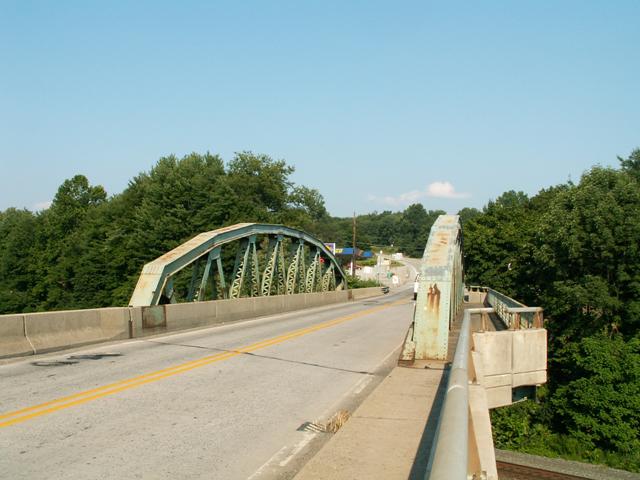
It often seems like Pennsylvania has more through trusses than pony trusses, due to all the large rivers. This bridge crosses a railroad line and is in fact a pony truss, and as such is a quality representation of a 1930s pony truss in Pennsylvania. The deck and railings have been altered, particularly on the approach, but the trusses retain integrity.
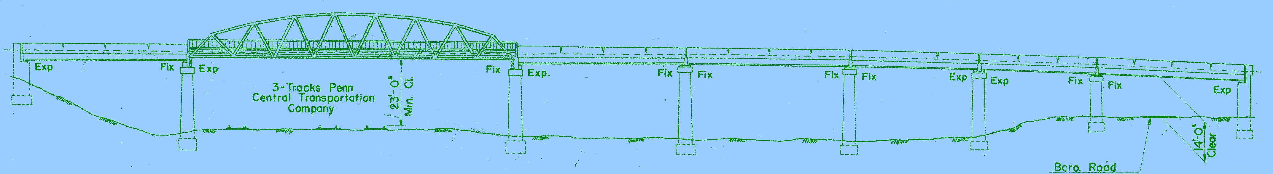
Information and Findings From Pennsylvania's Historic Bridge InventoryDiscussion of Bridge The skewed, 417'-long bridge consists of a 106' long riveted Warren pony truss with a polygonal upper chord span and 7 rolled stringer approach spans (2 @ 35.6', 1 @ 49', 1 @ 51.9', 1@ 52.11', and 1 @ 54.11'); 6 to the west of the truss span and 1 to the east. The trusses are traditionally composed with built up members. The substructure consists of concrete abutments and concrete column and cap beam bents. The safety shape barriers date to ca. 1985. The bridge is an example of common technologies and is not technologically significant, but it appears to be significant in association with the Pennsylvania RR main line. The bridge was designed and built by the railroad on the eve of its long period of decline. Discussion of Surrounding Area The bridge carries a 2 lane road with one sidewalk over the former PRR main line railroad and a borough road near the intersection of SR 56 and 711 near the borough of Seward. Two other railroad tracks have been removed. PHMC has determined the PRR main line from the New Jersey to the Ohio state lines an eligible resource, but no period of significance or rating of evaluation of contributing and noncontributing resources was done as part of the determination. The bridge is outside of Seward and is not part of a potential historic district. Bridge Considered Historic By Survey: Yes, By Association With Railroad |
![]()
![]()
This historic bridge has been demolished. This map is shown for reference purposes only.
Coordinates (Latitude, Longitude):
Search For Additional Bridge Listings:
Bridgehunter.com: View listed bridges within 0.5 miles (0.8 kilometers) of this bridge.
Bridgehunter.com: View listed bridges within 10 miles (16 kilometers) of this bridge.
Additional Maps:
Google Streetview (If Available)
GeoHack (Additional Links and Coordinates)
Apple Maps (Via DuckDuckGo Search)
Apple Maps (Apple devices only)
Android: Open Location In Your Map or GPS App
Flickr Gallery (Find Nearby Photos)
Wikimedia Commons (Find Nearby Photos)
Directions Via Sygic For Android
Directions Via Sygic For iOS and Android Dolphin Browser
USGS National Map (United States Only)
Historical USGS Topo Maps (United States Only)
Historic Aerials (United States Only)
CalTopo Maps (United States Only)

© Copyright 2003-2024, HistoricBridges.org. All Rights Reserved. Disclaimer: HistoricBridges.org is a volunteer group of private citizens. HistoricBridges.org is NOT a government agency, does not represent or work with any governmental agencies, nor is it in any way associated with any government agency or any non-profit organization. While we strive for accuracy in our factual content, HistoricBridges.org offers no guarantee of accuracy. Information is provided "as is" without warranty of any kind, either expressed or implied. Information could include technical inaccuracies or errors of omission. Opinions and commentary are the opinions of the respective HistoricBridges.org member who made them and do not necessarily represent the views of anyone else, including any outside photographers whose images may appear on the page in which the commentary appears. HistoricBridges.org does not bear any responsibility for any consequences resulting from the use of this or any other HistoricBridges.org information. Owners and users of bridges have the responsibility of correctly following all applicable laws, rules, and regulations, regardless of any HistoricBridges.org information.
![]()