We Recommend:
Bach Steel - Experts at historic truss bridge restoration.
Cambridge Springs Bridge

Primary Photographer(s): Nathan Holth
Bridge Documented: July 1, 2006
Cambridge Springs: Crawford County, Pennsylvania: United States
1901 By Builder/Contractor: Massillon Bridge Company of Massillon, Ohio
1987
200.0 Feet (61 Meters)
203.0 Feet (61.9 Meters)
21.3 Feet (6.49 Meters)
1 Main Span(s)
200006090001140

View Information About HSR Ratings
Bridge Documentation
This bridge no longer exists!
Bridge Status: This historic, National Register Eligible bridge was demolished and replaced by PennDOT in 2020!This bridge's song is:
Narrative Update: It should be noted that just prior to this bridge being replaced, HistoricBridges.org sent repeated letters to PennDOT and PHMC to get this bridge recognized as National Register Eligible. While this ultimately did not save the bridge, it made it clear to the public what was being destroyed. Also as a result, mitigation funds were secured to preserve a different historic bridge in Pennsylvania.
View Archived National Bridge Inventory Report - Has Additional Details and Evaluation

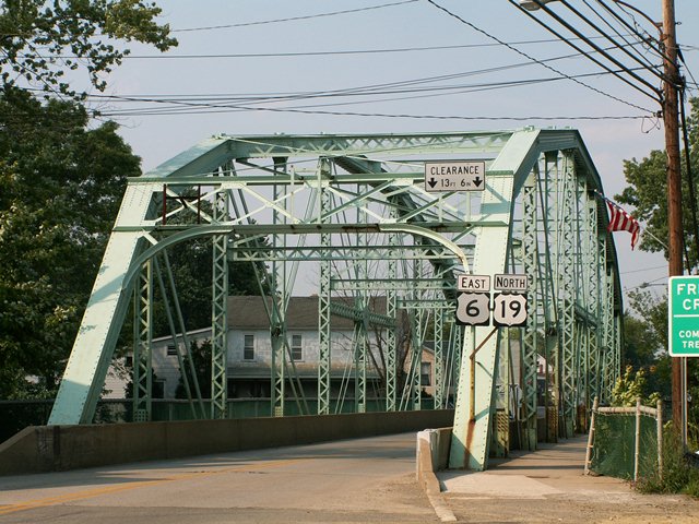
This bridge, constructed in 1901, was a bridge ahead of its time. Its roadway is wide for a bridge of this age, and its members are quite massive for a bridge of this age. These characteristics make a bridge able to carry even today's fairly heavy US Highway traffic that crosses the bridge, something that would not be true for most 1901 truss bridges. The bridge, with its arch-like shape, complex Pennsylvania truss configuration, and built-up beams with v-lacing and lattice, is a beautiful centerpiece for Cambridge Springs. It functions as a beautiful, historic gateway landmark for the community. The bridge does have some repairs and minor changes that have been made, but the bridge overall retains its original materials and design. The historical photo shown above shows the bridge soon after its construction.
The finding of this bridge as not eligible for the National Register of Historic Places might have made sense years ago when the Historic Bridge Inventory was completed for Pennsylvania. However, the finding is ridiculously outdated in the context of today's dwindling population of metal truss bridges in Pennsylvania. Those truss bridges in the Commonwealth bearing the Pennsylvania truss configuration are particularly hard hit with very few surviving examples. Each surviving example should be considered eligible as an example of a rare truss configuration... a truss configuration first developed and promoted by the historically significant Pennsylvania-based Pennsylvania Railroad. Anyone who makes a different assessment should have their competency questioned. It is hard to imagine a truss bridge type that is more strongly connected to Pennsylvania's heritage than a metal truss bridge with the Pennsylvania truss configuration.

Above: Historical postcard of bridge.
Information and Findings From Pennsylvania's Historic Bridge InventoryDiscussion of Bridge The 1901, pin connected, single span, 203'-long, Pennsylvania thru truss bridge is supported on concrete abutments with wingwalls. The trusses have no innovative or distinctive details. The bridge was modified in 1986 when the lower end of all verticals had plates bolted and welded to them and the sub-ties were strengthened by added material. The bridge is not an early or complete example of its type and design, which is not uncommon throughout the state. The altered bridge is neither historically nor technologically significant. Discussion of Surrounding Area The bridge carries a 2 lane highway and sidewalks over a stream in the northeast corner of the borough of Cambridge Springs. The bridge is one block west of the late 19th century central business district, which has historic district potential, but the bridge is not part of the district. In between are mid-20th century buildings and vacant lots. Bridge Considered Historic By Survey: No |
![]()
Photo Galleries and Videos: Cambridge Springs Bridge
Bridge Photo-Documentation
Original / Full Size PhotosA collection of overview and detail photos. This gallery offers photos in the highest available resolution and file size in a touch-friendly popup viewer.
Alternatively, Browse Without Using Viewer
![]()
Bridge Photo-Documentation
Mobile Optimized PhotosA collection of overview and detail photos. This gallery features data-friendly, fast-loading photos in a touch-friendly popup viewer.
Alternatively, Browse Without Using Viewer
![]()
Maps and Links: Cambridge Springs Bridge
This historic bridge has been demolished. This map is shown for reference purposes only.
Coordinates (Latitude, Longitude):
Search For Additional Bridge Listings:
Bridgehunter.com: View listed bridges within 0.5 miles (0.8 kilometers) of this bridge.
Bridgehunter.com: View listed bridges within 10 miles (16 kilometers) of this bridge.
Additional Maps:
Google Streetview (If Available)
GeoHack (Additional Links and Coordinates)
Apple Maps (Via DuckDuckGo Search)
Apple Maps (Apple devices only)
Android: Open Location In Your Map or GPS App
Flickr Gallery (Find Nearby Photos)
Wikimedia Commons (Find Nearby Photos)
Directions Via Sygic For Android
Directions Via Sygic For iOS and Android Dolphin Browser
USGS National Map (United States Only)
Historical USGS Topo Maps (United States Only)
Historic Aerials (United States Only)
CalTopo Maps (United States Only)


