

View Information About HSR Ratings
This bridge's song is:
This bridge was closed to traffic for nearly two decades, and was a well-known attraction to people who lived in the area. It formed a sort of central point for the Beards Hill State Game Area, and was one of the more popular areas of the state game area, which is home to one of the few landscapes in the thumb of Michigan that is not flat as a pancake. Mill Creek, which has a nasty habit of flooding in this area, finally got the better of the bridge, and its fieldstone abutments, and caused the bridge to collapse in 2002.
Unlike states like Pennsylvania that have bridge substructures composed of fine ashlar masonry crafted by expert stonemasons, Michigan's stone abutments tend to look like the local residents gathered up all the loose boulders in their fields, and piled them together, stuffing mortar in between to get the random rubble to hold together. In this sense, the mortar plays a greater role in holding the abutment together than with ashlar where the stone would tend to stack up better. As a result, when abandoned, these primitive Michigan abutments rapidly deteriorate and collapse.
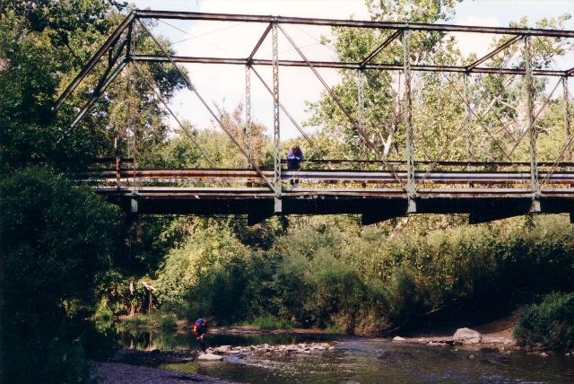
The bridge was a pin connected through truss. V-lacing was present on the vertical members, which was on the sides of the verticals rather than on the front and back, which is more common. Based on the photos I have, which are few, it looks like an eight panel bridge. The deck was asphalt on top, and probably had wood below. Portal bracing was an a-frame design. Original simple metal railings remained above modern guardrails on the bridge. The bridge sat on fieldstone abutments, which are what gave out, causing the bridge to collapse. No efforts to preserve or restore this historic bridge were made, which is sad, considering it helped connect the state game area, which has lands on both sides of where the bridge was.
There was another truss bridge very near here, which was gone long before this bridge. It was north of M-136 over Black River, and was the Feick Road Bridge. Large fieldstone abutments are visible when the leaves are off the trees, north of the ugly M-136 slab bridge. The nearby M-136 Bridge was originally a 1928 deck plate girder. The current M-136 bridge was built a number of years ago, and is a two lane bridge with paved shoulders that are two times the width of the paved shoulders on the road leading up to the bridge. This is an incredible waste of money; the bridge is so wide, that no parking signs are posted on the bridge, so people don't think the bridge was built to park on. You certainly could, it is so wide.

Above: The bridge as featured in the 1970 Port Huron Northern High School Yearbook. Thanks to Susie Babcock for finding this!
I always liked bridges, even as a tiny kid. However, if a single event could be stated as my reason for sparking my passion for starting this website and photo-documenting historic bridges, the finger could be pointed at the collapse of this bridge, which I knew and loved since I was a tiny kid. The sudden loss of this bridge shocked me, and led to to wonder if there were more bridges around similar to this one that remained. I discovered MDOT's historic bridge website and began to photograph the truss bridges, and other historic bridges listed on the site. The Frith Road Bridge was the only other remaining through truss in St. Clair County when this bridge fell, and was actually the first bridge I photographed with the intention of documenting it.
![]()
![]()
This historic bridge has been demolished. This map is shown for reference purposes only.
Coordinates (Latitude, Longitude):
Search For Additional Bridge Listings:
Bridgehunter.com: View listed bridges within 0.5 miles (0.8 kilometers) of this bridge.
Bridgehunter.com: View listed bridges within 10 miles (16 kilometers) of this bridge.
Additional Maps:
Google Streetview (If Available)
GeoHack (Additional Links and Coordinates)
Apple Maps (Via DuckDuckGo Search)
Apple Maps (Apple devices only)
Android: Open Location In Your Map or GPS App
Flickr Gallery (Find Nearby Photos)
Wikimedia Commons (Find Nearby Photos)
Directions Via Sygic For Android
Directions Via Sygic For iOS and Android Dolphin Browser
USGS National Map (United States Only)
Historical USGS Topo Maps (United States Only)
Historic Aerials (United States Only)
CalTopo Maps (United States Only)

© Copyright 2003-2025, HistoricBridges.org. All Rights Reserved. Disclaimer: HistoricBridges.org is a volunteer group of private citizens. HistoricBridges.org is NOT a government agency, does not represent or work with any governmental agencies, nor is it in any way associated with any government agency or any non-profit organization. While we strive for accuracy in our factual content, HistoricBridges.org offers no guarantee of accuracy. Information is provided "as is" without warranty of any kind, either expressed or implied. Information could include technical inaccuracies or errors of omission. Opinions and commentary are the opinions of the respective HistoricBridges.org member who made them and do not necessarily represent the views of anyone else, including any outside photographers whose images may appear on the page in which the commentary appears. HistoricBridges.org does not bear any responsibility for any consequences resulting from the use of this or any other HistoricBridges.org information. Owners and users of bridges have the responsibility of correctly following all applicable laws, rules, and regulations, regardless of any HistoricBridges.org information.
![]()