

View Information About HSR Ratings
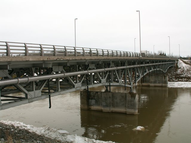
This bridge was constructed in 1959, and all connections are bolted. Rivets are present on the bridge as well, holding the built-up beams together. It appears all shop work for this bridge used riveting, and all field work used bolting. This is evidence of the transition away from riveting that occurred in the middle of the 20th Century. There is no v-lacing or lattice on the bridge either, another mid-20th Century transition, this one being a movement away from complex member designs. As a result, for a truss bridge, its members are perhaps not as attractive as other deck trusses when viewed up close. The overall shape of the bridge is pleasing however. On the other hand, overall continuous design of the bridge, giving the bridge an arched appearance, makes this bridge look quite stunning when viewed from the distance. On the bridge, their is little to clue motorists in to the truss nature of the bridge. Only the uncommon all-metal railings, which may be original, clue people in to the possibility that the bridge might be a bit more than the standard beam bridge. The shape of the bridge trusses is that which cantilever deck trusses usually take. However, as all connections appear to be rigid, the bridge appears to function as a continuous truss. A historical photos appears to show the bridge being constructed using the cantilever method however. It is possible to build using the cantilever method, but fasten all connections rigid to produce a continuous truss. A historical photos of the bridge's construction is available here. The bridge has three truss lines.
Previous bridges at this general location include a wooden truss, whose historical photo is here. This in turn was apparently replaced by a two span through truss bridge following an unusual double-intersection Warren truss design found on a surprising number of Ontario bridges. A historical photo is here. This bridge appears to have collapsed in a flood as shown here.
![]()
![]()
![]()
Coordinates (Latitude, Longitude):
Search For Additional Bridge Listings:
Additional Maps:
Google Streetview (If Available)
GeoHack (Additional Links and Coordinates)
Apple Maps (Via DuckDuckGo Search)
Apple Maps (Apple devices only)
Android: Open Location In Your Map or GPS App
Flickr Gallery (Find Nearby Photos)
Wikimedia Commons (Find Nearby Photos)
Directions Via Sygic For Android
Directions Via Sygic For iOS and Android Dolphin Browser

© Copyright 2003-2025, HistoricBridges.org. All Rights Reserved. Disclaimer: HistoricBridges.org is a volunteer group of private citizens. HistoricBridges.org is NOT a government agency, does not represent or work with any governmental agencies, nor is it in any way associated with any government agency or any non-profit organization. While we strive for accuracy in our factual content, HistoricBridges.org offers no guarantee of accuracy. Information is provided "as is" without warranty of any kind, either expressed or implied. Information could include technical inaccuracies or errors of omission. Opinions and commentary are the opinions of the respective HistoricBridges.org member who made them and do not necessarily represent the views of anyone else, including any outside photographers whose images may appear on the page in which the commentary appears. HistoricBridges.org does not bear any responsibility for any consequences resulting from the use of this or any other HistoricBridges.org information. Owners and users of bridges have the responsibility of correctly following all applicable laws, rules, and regulations, regardless of any HistoricBridges.org information.
![]()