

View Information About HSR Ratings
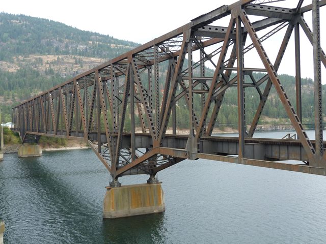
This is a three span cantilever truss bridge of unusual design. In traditional design, a three span cantilever truss includes anchor arms extending from piers to abutments, and in the center two cantilever arms that extend from each pier, and hold a suspended span in the center. With this bridge, its the opposite. The center span can be thought of as the two anchor arms. At the ends of the bridge, a cantilever arm extends from the piers halfway to the abutments. From this point, the cantilever arm holds a half-suspended span which rests on the abutment at the far ends of the bridge. Evidence of this design can be most easily seen by observing the pin and hanger connection that indicates a cantilever arm holding the half-suspended spans.

Another unusual detail of this bridge are the supplemental cables that are found at the abutments. Cables extend from the deck down to the abutment at each side of the bridge, and the others run from halfway along the bottom chords down to the face of the abutment on each side of the bridge. The bottom chord cables appear to be slack, suggesting they are intended to compensate for some sort of movement from the usual position of the bridge. It is not known if it is intended to accommodate earthquakes or live loads (trains). Although the cables may not be original, the attachment to the bottom chord is riveted suggesting the presence of cables here is either original or a pre-1970 alteration.

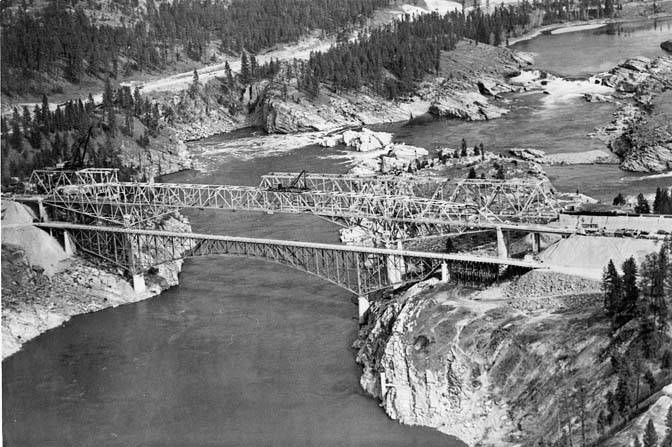
A highway bridge was built next to this bridge at the same time. Built at the exact same time over the exact same river right next to each other, the two bridges of the same general type (cantilevered through truss) with their vastly different design details and appearances contrast the different approach taken to bridge design by the railroad and the state highway department. The railroad bridge was built at the same time as the highway bridge, allowing it to accommodate the massive reservoir then recently created by the Grand Coulee Dam.
American Bridge Company provided the following information:
This contract involved the fabrication and erection of a five-span, 1,216', single track, through riveted truss railroad bridge consisting of one 228' and one 152' suspended spans, two 114' cantilever arms, and one 608' center anchor span. The truss is 30' wide and 60' tall. The project was a part of the Grand Coulee Irrigation Program on the Columbia River, made necessary by the construction of the Grand Coulee Dam. Fabrication occurred at the Gary, Indiana and Ambridge, Pennsylvania plants.
![]()
![]()
![]()
Coordinates (Latitude, Longitude):
Search For Additional Bridge Listings:
Bridgehunter.com: View listed bridges within 0.5 miles (0.8 kilometers) of this bridge.
Bridgehunter.com: View listed bridges within 10 miles (16 kilometers) of this bridge.
Additional Maps:
Google Streetview (If Available)
GeoHack (Additional Links and Coordinates)
Apple Maps (Via DuckDuckGo Search)
Apple Maps (Apple devices only)
Android: Open Location In Your Map or GPS App
Flickr Gallery (Find Nearby Photos)
Wikimedia Commons (Find Nearby Photos)
Directions Via Sygic For Android
Directions Via Sygic For iOS and Android Dolphin Browser
USGS National Map (United States Only)
Historical USGS Topo Maps (United States Only)
Historic Aerials (United States Only)
CalTopo Maps (United States Only)

© Copyright 2003-2024, HistoricBridges.org. All Rights Reserved. Disclaimer: HistoricBridges.org is a volunteer group of private citizens. HistoricBridges.org is NOT a government agency, does not represent or work with any governmental agencies, nor is it in any way associated with any government agency or any non-profit organization. While we strive for accuracy in our factual content, HistoricBridges.org offers no guarantee of accuracy. Information is provided "as is" without warranty of any kind, either expressed or implied. Information could include technical inaccuracies or errors of omission. Opinions and commentary are the opinions of the respective HistoricBridges.org member who made them and do not necessarily represent the views of anyone else, including any outside photographers whose images may appear on the page in which the commentary appears. HistoricBridges.org does not bear any responsibility for any consequences resulting from the use of this or any other HistoricBridges.org information. Owners and users of bridges have the responsibility of correctly following all applicable laws, rules, and regulations, regardless of any HistoricBridges.org information.
![]()