Information and Findings From Calgary Historic Resources
Discussion of Bridge
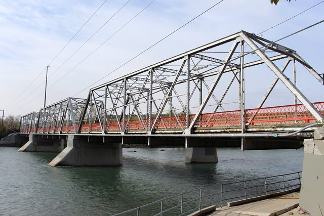
Hextall (Shouldice) Bridge
Year of Construction:
1910
Community: MONTGOMERY
Resource Type: City Wide Historic
Resource
Original Use Type: Transport
Original Use SubType: Bridge
Architectural Style: N/A
Architect: N/A
Builder: Algoma Bridge
Company
Provincial Master Plan Theme: Transportation
Development
Era: 1906 to 1913 (Pre WWI Boom, Age of Optimism)
Legal Description:
N/A
Other Significant Dates: As well as the year of completion other
significant dates are: 1950 - Removal of street railway tracks 1986 -
adjacent replacement bridge built 1987 - renamed as Hextall Bridge 1988
- listed as an Alberta Registered Historic Resource
Legally
Protected/Federally Recognized:
Federal: No
Provincial: No
Registered: Yes
Municipal: No
HERITAGE SIGNIFICANCE
The
Shouldice (Hextall) Bridge was constructed in 1910 to 1911 by John
Hextall as part of a land development project that he has initiated in
Bowness. Hextall came to the Calgary area from England in 1908 and
purchased the Bowness Ranch. Soon after, when the building boom was
underway, he decided to turn the area into a suburb designed to attract
wealthy residents. During a trip to England in 1909, he formed the
Bowness Land Development Company.
After returning to Calgary, he
undertook several projects in rapid succession. To attract buyers, he
built a golf course and club, constructed an electrical generating
station, developed the two islands in the Bow River into a park site,
and built a 75,000 dollar three span steel truss bridge connecting
Bowness to Calgary which was completed in 1911. That fall, he reached an
agreement with the city of Calgary whereby he would donate the park and
the bridge and pay for construction to supply hourly transit service.
The streetcars began running in June 1912 and many Calgarians began to
enjoy outings at Bowness Park.
Within the next two years,
however, the land boom collapsed, Hextall died, and World War One began.
Only a few houses had actually been built and land values depreciated
rapidly. A Soldiers' Settlement built in 1946 brought new residents, and
by 1960 the population had reached 9,000. In 1952 the town of Bowness
was incorporated, and in 1964 it became part of the city of Calgary. The
streetcars continued to run across the Shouldice (Hextall) Bridge until
the beginning of the 1950s, when the bridge was turned over to bus and
automobile traffic.
Significance Summary:
This site is
significant because:
- it is symbolically valuable as an integral
component to the historic development of the Bowness community.
(Symbolic value - community significance)
- it is the only
surviving example of a Pratt through-truss bridge in Calgary; it is
distinguished by its distinctive framework of steel structural members;
(Design value - City Wide significance)
- it is a landmark in the
Bowness and Montgomery areas both currently and historically as a
gateway to those communities; it was one of the few built features in
what was otherwise a rural and mostly undeveloped area; it became known
to generations of Calgarians who traversed the streetcar line, via the
bridge, to Bowness Park; (Landmark value - community significance)
- it was an important component of the street-railway system to
Bowness; the street-railway system enabled transportation activity that
was integral to Calgary's development; the bridge is one of a small
number of infrastructure elements that remain to recall the
street-railway system (Activity value - City Wide significance)
-
the bridge is closely associated with John Hextall, the developer of
Bowness, and is one of a few tangible features that recall Hextall's
contribution to the area's development (Person value - City Wide
significance)
Statement of Significance
Description:
The
Hextall (Shouldice) Bridge, constructed in 1910, is a three-span, Pratt
through-truss, steel bridge with a straight top cord. The bridge spans
the Bow River and connects the neighbourhoods of Bowness and Montgomery.
Originally a road and street railway bridge, it is now part of the Bow
River Pathway, a bicycle and pedestrian system.
Heritage Value:
The Hextall (Shouldice) Bridge, built in 1910, is symbolically valuable
as an integral component to the historic development of the Bowness
community. Construction of the bridge made it possible to access the
Bowness area from Calgary, leading to the first development of Bowness
during the pre-World War One boom (1909-13). First known simply as the
Hextall Bridge, it became commonly known as the Shouldice Bridge, in
reference to the Shouldice family farm east of the river, which also
lent its name to the area.
The original development of Bowness
was led by John Hextall (1861-1914), who sought to transform the area
into an idyllic garden suburb of spacious lots and beautiful homes.
Hextall migrated from England to Calgary in 1908 and subsequently
purchased the Bowness Ranche to become the site of his ideal suburban
community. Hextall's construction of the bridge initiated development of
the community and was first used by those who had purchased land in his
subdivision. In 1911 however, Hextall secured an agreement with the City
to accept ownership of the bridge to the city (plus two islands for park
use) in exchange for an extension of the street railway system to
Bowness via the bridge. Extension of the street railway system was a key
part of Hextall's plan to entice owners to what was then a rural and
far-flung area.
Despite Hextall's plan, only a small number of
houses, plus a golf course and elegant clubhouse, were constructed at
Bowness before the economic bust of 1913 halted most construction until
after World War II. For this reason, the bridge is one of a few tangible
features that recall Hextall's contribution to the development of the
Bowness area of Calgary.
The Hextall (Shouldice) Bridge is
significant in its design as the only surviving example of its kind in
Calgary - a Pratt through-truss road bridge. Three spans in length, the
bridge is distinguished by its distinctive framework of steel structural
members on each side of the deck, and above. Truss bridges are made up
of straight pieces of steel connected to form a framework of triangles,
the most structurally stable geometric form. A straight cord forms the
top of each side. This type of truss bridge is practical for use with
spans up to 250 feet in length, and was widely used by railway companies
and for highway bridge construction.
Hextall was responsible for
the construction of this bridge which involved obtaining the necessary
permits, contracting the construction of the abutments and piers and
obtaining the superstructure from the Algoma Steel Bridge Company.
The bridge is a landmark in the Bowness and Montgomery areas both
currently and historically. Since the original development of the
Bowness community, the bridge has served as a gateway to the community.
Historically, it was one of the few built features in what was otherwise
a rural and mostly undeveloped area and served as both a road and street
railway bridge. During the era that the street railway connected Bowness
to Calgary (1912-50), it became known to generations of Calgarians who
traversed the line, via the bridge, to Bowness Park, an immensely
popular leisure and resort area.
Until the adjacent replacement
bridge was built in 1986 the historic bridge functioned as the community
gateway, being the Bowness Road link over the Bow River. Since its
replacement, the bridge has remained in use by users of the Bow River
pathway system for bicycles and pedestrians. Its distinctive design and
presence continues its role as a visual gateway and landmark feature to
the communities of Montgomery and Bowness.
Additionally, the
bridge was an important component of the street-railway system to
Bowness. The street-railway system enabled transportation activity that
was integral to the development of the city, and particularly to Bowness;
the bridge is one of a small number of infrastructure elements that
remain to recall the street-railway system.
Character Defining
Elements:
The character-defining elements of the property include,
but are not limited to:
- Three-span, Pratt through-truss bridge
with sides that comprise a framework of steel structural elements, in a
triangular arrangement, connected at the top;
- the maker's plates at
each end of the bridge with "Algoma Steel Bridge Company";
- Two
concrete poured-in-place abutments;
- Two concrete poured-in-place
piers;
- its original placement at the location.
Sources
Occupants (Henderson's Directory Search):
NA
Owners
(Historical Title Search):
NA
Additional Sources:
Bowness
Historical Society, Bowness: Our Village in the Valley, Calgary 2005.
pp. 19-33 and 51-59. These pages provide background information on John
Hextall and his negotiations with the city for the extension of the
street railway.
Hatcher, Colin. Stampede City Streetcars The
Story of the Calgary Municipal Railway. Montreal: Railfare Enterprises,
1975. pp. 27-28 These pages outline the beginning and expansion of the
street railway system
Welin, R.A. Bridges of Calgary 1882 - 1977
Calgary: City of Calgary. 1977. p 41. This source provides construction
details on the Hextall bridge
Primary Sources
City of
Calgary Corporate Records
Agreement 318 Agreement with John
Hextall March 1911. This source documents the agreement between John
Hextall and the City of Calgary for the extension of the street railway
to Bowness
Mitchell outlining proposal for street railway extension
to Bowness.
City Clerk's Papers File 297 Correspondence between
City Clerk and City Solicitor D.S. Moffat October 28 - September 20,
1911 regarding the construction of Bowness extension of the street
railway.
City of Calgary Papers File 227 which documents the
negotiations between John Hextall and the City of Calgary for the
extension of the Street Railway to his development in Bowness, the
transfer of the bridge across the Bow River to the City of Calgary.
Map from City of Calgary Papers File 227 which shows route of street
railway indicated along with John Hextall Bridge
Newspapers
Morning Albertan June 29 1911 advertisement by John Hextall regarding
use of his bridge
Bridge Considered Historic By Survey: Yes |