![]()
![]()
Status: Open to traffic
Location: 40.421862,-98.571871
Carries S. Prosser Avenue (CR 11-4W) over Cottonwood Creek
Design: truss/pony
Design Details: Pony truss
Total Length: 42.0 Feet
Span Length: 40.0 Feet
Overview: Pony truss bridge over Cottonwood Creek on S. Prosser Avenue (CR 11-4W)
History: Built ca. 1935
Built: ca. 1935
Location: Adams County
View Bridge Information In Wayback Machine
![]()
![]()
Status: Open to traffic
Location: 40.420464,-98.552939
Carries S. Roseland Avenue (CR 11-3W) over Cottonwood Creek
Design: arch/deck
Design Details: Arch
Total Length: 49.9 Feet
Span Length: 49.9 Feet
Overview: Concrete arch bridge over Cottonwood Creek on S. Roseland Avenue (CR 11-3W)
History: Built 1924
Built: 1924
Location: Adams County
View Bridge Information In Wayback Machine
![]()
![]()
Status: Open to traffic
Location: 40.684193,-98.393142
Carries W. 94th Street over Flat Creek
Design: arch/deck
Design Details: Arch
Total Length: 29.9 Feet
Span Length: 28.9 Feet
Overview: Concrete arch bridge over Flat Creek on W. 94th Street
History: Built 1925
Built: 1925
Location: Adams County
View Bridge Information In Wayback Machine
![]()
![]()
Status: Open to traffic
Location: 40.368703,-98.610531
Carries S. Sand Avenue over Little Blue River
Design: truss/pony
Design Details: Pony truss
Total Length: 51.8 Feet
Span Length: 49.9 Feet
Overview: Pony truss bridge over Little Blue River on S. Sand Avenue
History: Built ca. 1935
Built: ca. 1935
Location: Adams County
View Bridge Information In Wayback Machine
![]()
![]()
Status: Open to traffic
Location: 40.399508,-98.572134
Carries S. Prosser Avenue (CR 11-4W) over Little Blue River
Design: truss/pony
Design Details: Pony truss
Total Length: 91.9 Feet
Span Length: 89.9 Feet
Overview: Pony truss bridge over Little Blue River on S. Prosser Avenue (CR 11-4W)
History: Built ca. 1935
Built: ca. 1935
Location: Adams County
View Bridge Information In Wayback Machine
![]()
![]()
Status: Open to traffic
Location: 40.408921,-98.459463
Carries Cimarron Road over Little Blue River
Design: truss/pony
Design Details: Pony truss
Total Length: 81.0 Feet
Span Length: 80.1 Feet
Overview: Pony truss bridge over Little Blue River on Cimarron Road
History: Built 1916
Built: 1916
Location: Adams County
View Bridge Information In Wayback Machine
![]()
![]()
Status: Open to traffic
Location: 40.583830,-98.392490
Carries Railroad over South Burlington Avenue (US 34)
Design: beam/stringer/steel
Design Details: Steel stringer
Total Length: 0.0 Feet
Span Length: 0.0 Feet
Overview: Steel stringer bridge over South Burlington Avenue (US 34) on Railroad
History:
Built:
Location: Adams County
View Bridge Information In Wayback Machine
![]()
274875
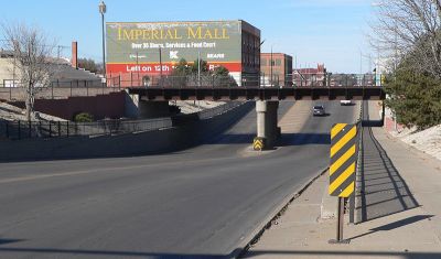
File:Hastings, Nebraska Burlington Ave underpass 1.JPG
Photo taken by Wikipedia user Ammodramus
274876
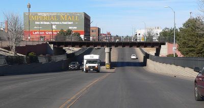
File:Hastings, Nebraska Burlington Ave underpass 2.JPG
Photo taken by Wikipedia user Ammodramus
274877
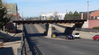
File:Hastings, Nebraska Burlington Ave underpass 3.JPG
Photo taken by Wikipedia user Ammodramus
274878
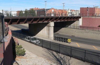
File:Hastings, Nebraska Burlington Ave underpass 4.JPG
Photo taken by Wikipedia user Ammodramus
![]()
Status: Open to traffic
Location: 40.611350,-98.605645
Carries W. 26th Street (CR 80) over BNSF Railway
Design: girder/deck/plate
Design Details: Deck plate girder
Total Length: 245.1 Feet
Span Length: 50.0 Feet
Overview: Girder bridge over BNSF Railway on W. 26th Street (CR 80)
History: Built 1937
Built: 1937
Location: Adams County
View Bridge Information In Wayback Machine
![]()
![]()
Status: Open to traffic
Location: 40.538781,-98.534828
Carries S. Conestoga Avenue over West Branch Thirty-Two Mile Creek
Design: beam/stringer/wood
Design Details: Timber stringer
Total Length: 61.0 Feet
Span Length: 29.9 Feet
Overview: Timber stringer bridge over West Branch Thirty-Two Mile Creek on S. Conestoga Avenue
History: Built ca. 1935
Built: ca. 1935
Location: Adams County
View Bridge Information In Wayback Machine
![]()
![]()
Status: Open to traffic
Location: 40.467098,-98.477619
Carries S. Osage Avenue (CR 10-5W) over Scott Creek
Design: beam/stringer/wood
Design Details: Timber stringer
Total Length: 71.9 Feet
Span Length: 19.0 Feet
Overview: Timber stringer bridge over Scott Creek on S. Osage Avenue (CR 10-5W)
History: Built ca. 1935
Built: ca. 1935
Location: Adams County
View Bridge Information In Wayback Machine
![]()
![]()
Status: Open to traffic
Location: 40.495251,-98.429757
Carries W. Oregon Trail Road over Thirty-Two Mile Creek
Design: beam/stringer/wood
Design Details: Timber stringer
Total Length: 77.1 Feet
Span Length: 39.0 Feet
Overview: Timber stringer bridge over Thirty-Two Mile Creek on W. Oregon Trail Road
History: Built ca. 1935
Built: ca. 1935
Location: Adams County
View Bridge Information In Wayback Machine
![]()
![]()
Status: Open to traffic
Location: 40.466457,-98.370870
Carries E. Sundown Road (CR 62) over Pawnee Creek
Design: beam/stringer/wood
Design Details: Timber stringer
Total Length: 60.0 Feet
Span Length: 20.0 Feet
Overview: Timber stringer bridge over Pawnee Creek on E. Sundown Road (CR 62)
History: Built ca. 1935
Built: ca. 1935
Location: Adams County
View Bridge Information In Wayback Machine
![]()
![]()
Status: Open to traffic
Location: 40.595089,-98.382381
Carries Eastside Blvd. over Heartwell Lake
Design: beam/stringer
Design Details: Stringer
Total Length: 27.9 Feet
Span Length: 24.9 Feet
Overview: Stringer bridge over Heartwell Lake on Eastside Blvd.
History: Built 1930
Built: 1930
Location: Adams County
View Bridge Information In Wayback Machine
![]()
Special Bridge Conditions Legend: R - Former location of relocated bridge. ! - At risk for demolition or destruction. X - Confirmed demolished or collapsed. S - Dismantled and/or in storage. L - Severe loss of historic integrity due to alteration.
![]()

![]()