![]()
![]()
Status: Open to traffic
Location: 32.808889,-95.278611
Carries CR 3987 over Turkey Creek
Design: truss/pony/warren/verticals
Design Details: Warren pony truss with all verticals
Total Length: 51.8 Feet
Span Length: 49.9 Feet
Overview: Pony truss bridge over Turkey Creek on CR 3987
History: Built 1950
Built: 1950
Location: Wood County
View Bridge Information In Wayback Machine
![]()
226102

View looking north
Photo taken by michael wilson in February 2012
226103

West side
Photo taken by michael wilson in February 2012
226104

East side
Photo taken by michael wilson in February 2012
![]()
Status: Replaced by a new bridge
Location: 32.838889,-95.335833
Carries CR 3155 over Turkey Creek
Design: truss/pony
Design Details: Pony truss
Total Length: 50.9 Feet
Span Length: 49.9 Feet
Overview: Lost pony truss bridge over Turkey Creek on CR 3155
History: Built 1936
Built: 1936
Location: Wood County
View Bridge Information In Wayback Machine
![]()
![]()
Status: Open to traffic
Location: 32.629196,-95.343269
Carries US-80 EB over Lake Fork Creek Relief #2
Design: beam/tee
Design Details: Concrete tee beam
Total Length: 595.2 Feet
Span Length: 35.1 Feet
Overview: Concrete tee beam bridge over Lake Fork Creek Relief #2 on US-80 EB
History: Built 1938
Built: 1938
Location: Wood County
View Bridge Information In Wayback Machine
![]()
![]()
Status: Open to traffic
Location: 32.631944,-95.363889
Carries CR 2790 over Fork Cr Tr
Design: slab
Design Details: Slab
Total Length: 36.1 Feet
Span Length: 18.0 Feet
Overview: Slab bridge over Fork Cr Tr on CR 2790
History: Built 1922; rehabilitated 1930
Built: 1922
Location: Wood County
View Bridge Information In Wayback Machine
![]()
![]()
Status: Open to traffic
Location: 32.675536,-95.565211
Carries Us 80 EB over Sabine River Relief
Design: beam/tee
Design Details: Concrete tee beam
Total Length: 509.9 Feet
Span Length: 40.0 Feet
Overview: Concrete tee beam bridge over Sabine River Relief on Us 80 EB
History: Built 1942
Built: 1942
Location: Wood County
View Bridge Information In Wayback Machine
![]()
![]()
Status: Derelict/abandoned
Lake Country Trails of Mineola will be developing a bicycle/walking rails to trails. A walking/biking bridge will be built over the old iron ore structure. A path to the base of the culvert will be available for those who wish to take a closer look at the structure.
Location: 32.651724,-95.478492
Carries over
Design: culvert/stone
Design Details: Stone culvert built of hewn iron ore rocks.
Total Length: 20.0 Feet
Span Length: 0.0 Feet
Overview: Abandoned stone culvert bridge
History: Built in 1873 when the I&GN Railroad built a line from Troup, Texas to Mineola, Texas. This section of the I&GN was called the "Jenny".
Built: 1873
Location: Wood County
View Bridge Information In Wayback Machine
![]()
334227

Culvert after cleanup
Photo taken by Joyce Williams
334228

Culvert before clearing underbrush
Photo taken by Joyce Williams in January 2015
334229

Culvert in snow
Photo taken by Joyce Williams
334230

Culvert in snow
Photo taken by Joyce Williams in February 2015
334231

South Side of Culvert
Photo taken by Joyce Williams in March 2015
![]()
Status: Culverts are on abandoned MKT (Katy) Railroad which ran from Greenville, Texas to Mineola, Texas. This section of the Katy Railroad was called "The Plug".
The Lake Country Rails to Trails organization hope to one day establish a biking/walking trail along the abandoned Katy Railroad corridor from Mineola, TX to Alba, TX.
Location: 32.679084,-95.534981
Carries MKT Railroad over Unnamed creek
Design: culvert/concrete
Design Details: Concrete culvert
Total Length: 30.0 Feet
Span Length: 0.0 Feet
Overview: Abandoned concrete culvert bridge over Unnamed creek on MKT Railroad
History: The MKT (Katy) Railroad built the culverts in 1919 (see date at top center of culverts). These culverts replaced the ones built in 1881 when the Katy was built from Greenville to Mineola.
Built: 1919
Location: Wood County
View Bridge Information In Wayback Machine
![]()
335774
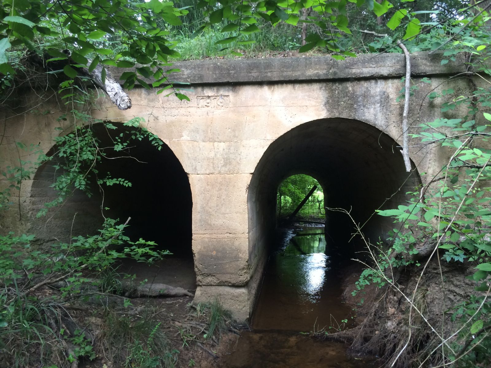
MKT (Katy) Railroad Cuiverts
Double culvert between Mineola, TX and Golden, TX
Photo taken by Joyce Williams in July 2015
335775

MKT (Katy) Railroad Culvert
1919
Photo taken by Joyce Williams in July 2015
Special Bridge Conditions Legend: R - Former location of relocated bridge. ! - At risk for demolition or destruction. X - Confirmed demolished or collapsed. S - Dismantled and/or in storage. L - Severe loss of historic integrity due to alteration.
![]()

![]()