Information and Findings From Calgary Historic Resources
Discussion of Bridge
Reconciliation Bridge
Alternate Names: formerly
Langevin Bridge
Address: 0 4 AV SE - View map
Year of
Construction: 1910
Community: BRIDGELAND/RIVERSIDE
Resource Type:
City Wide Historic Resource
Original Use Type: Transport
Original
Use SubType: Bridge
Architectural Style: N/A
Architect: Canadian
Bridge Company
Builder: Province of Alberta - Department of Public
Works
Provincial Master Plan Theme: Transportation
Development
Era: 1906 to 1913 (Pre WWI Boom, Age of Optimism)
Legal Description:
N/A
Other Significant Dates: 1888- 1910 - original wooden bridge sat
adjacent to the location of the current bridge. 1950s removal of street
railway tracks. 2017 Official renaming of the bridge. Recommendations of
the Calgary Aboriginal Urban Advisory Committee (CAUAC) in White Goose
Flying, A Report to Calgary City Council on the Indian Residential
School Truth and Reconciliation (White Goose Flying Report) which
included a recommendation to address the name of the Langevin Bridge.
Legally Protected/Federally Recognized:
Federal: No
Provincial: No
Registered: No
Municipal: No
Significance
Summary:
It is a representative example of a Parker Camelback
through-truss, steel bridge, which was the most frequently used design
for bridges built in Calgary from 1905 to 1912. It is the third oldest
of four surviving examples of this type of bridge in Calgary. (Design
Value - Community Significance)
It marks an ancient crossing of
the Bow River used by the First Nations as part of the Old North Trail
and from 1885-88 the primary Bow River Ferry crossing; it perpetuates
this historic transportation route. (Symbolic Value - City Wide
Significance)
Historically this bridge crossing allowed Calgary
to be a distribution centre for a hinterland north of the Bow River
following the arrival of the Canadian Pacific Railway. It remained part
of the primary highway route north from Calgary to Edmonton (via highway
No. 2) until the Deerfoot Trail was constructed in the late 1960s
(Symbolic Value - City Wide Significance)
As a component of the
street railway route, it is one of three historic crossings of the Bow
River which enabled the expansion of Calgary's urban area north of the
river during Calgary's early Twentieth Century boom (1909-13) and
subsequently enabled the extension of the system to Tuxedo Park, and was
part of a loop which followed Edmonton Trail, 16th Avenue and 10th
Street NW via the Hillhurst (Louise) Bridge. (Symbolic Value - City Wide
Significance)
It is a landmark due to its long-standing and
integral function as a primary transportation link. It is familiar to
many drivers, pedestrians and transit riders from the era of the
streetcars and those today. It is distinctive in appearance and it's a
'gateway' feature to both Bridgeland - Riverside and downtown Calgary
(Landmark Value - Community Significance)
Statement of
Significance
Description:
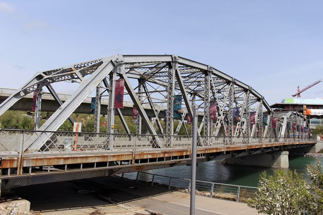
Reconciliation Bridge, built in 1910 is
a 116.58-meter-long and 14.02-meter-wide, two-span, Parker Camelback,
riveted-steel through-truss bridge on a concrete substructure made up of
one pier and two abutments. The bridge permits 4th Street North East to
cross the Bow River and connects the communities of Bridgeland -
Riverside to the downtowns area.
Heritage Value:
The heritage
value of the bridge derives from its design as a Parker, Camelback
through-truss bridge made of steel. It was the most frequently used
design for bridges built in Calgary from 1905 to 1912 by both the city
of Calgary and the Province of Alberta. It is the third oldest of four
surviving examples of this type of bridge in Calgary. It was constructed
in 1910 to accommodate the street railway. Its design was developed by
American Civil Engineer Charles H. Parker as a modified version of a
Pratt truss bridge, which had been the most popular type of standardized
bridge. The design was popular throughout North America because less
material was required in its construction while allowing it to maintain
the same strength as a through Pratt truss bridge of the same length.
The bridge holds symbolic value as the location of an ancient
crossing of the Bow River on the Old North Trail, an ancient aboriginal
transportation corridor; it perpetuates this historic transportation
route. When Fort Calgary was established in 1875, a section of the Old
North Trail became Macleod Trail, the main supply route between Fort
Calgary, Fort Macleod and Fort Benton further south in Montana. Between
1883 and 1888 the site of the bridge was the site of the primary ferry
crossing across the Bow in Calgary. The first bridge in this location,
named after Minister of Public Works Hector Langevin, went into use in
February 1888. It permitted Calgary to enhance its position as a
distribution centre for a hinterland north of the Bow following the
completion of the Canadian Pacific Railway. It was the first link in a
road transportation system north to Edmonton and beyond which included
the Calgary and Edmonton Trail, the Low Level Bridge across the North
Saskatchewan in Edmonton and the Athabasca Trail north of Edmonton. The
present bridge remained part of the main highway route extending north
of Calgary until the construction of the Deerfoot Trail in the late
1960s.
The present bridge built in 1910 was one of three crossing
of the Bow River instrumental in the expansion of Calgary north of the
Bow River during the Boom between 1909 and 1913. It was used to extend
the street railway north to the new subdivision of Tuxedo Park via the
Calgary and Edmonton Trail. The bridge permitted the establishment of a
street railway loop which followed the Calgary and Edmonton Trail, 16th
Avenue, 10th Street system and the Hillhurst (Louise) Bridge.
The
bridge is a landmark due to its long-standing and integral function as a
primary transportation link; its distinctive appearance; and its
`gateway' status as an entry feature to Bridgeland-Riverside and
Downtown Calgary. Historically it was familiar to streetcar passengers,
pedestrians, and motorists; it retains its familiarity with transit
users, pedestrians and motorists due to heavy usage. Community
appreciation of the bridge is evident, with its inclusion as part of a
historic walking tour prepared by the Community Association.
Character Defining Elements:
The character-defining elements of
Reconciliation Bridge included its
- Two-span superstructure of steel
lattice girder I beams and tie rods arranged in triangles with a curved
top cord;
- 1.5 meter steel sidewalks on either side of the
superstructure with a lattice balustrade; and
- historic location
marking the original crossing of the Bow River.
Additional
Sources:
Primary Sources
Province of Alberta Transportation
Department Bridge File 555. This file documents the establishment of the
crossing in 1888 and the construction of the 1910 bridge by the Canadian
Bridge Company.
Glenbow Library and Archives photographs NA-114-1,
NA-1785-1, NA-2003-114, NA-2399-95, NA-2524-1 and 2, NA-4081-10 and
ND-8-259.
Secondary Sources
Region of Waterloo. Spanning the
Generations: A Study of Old Bridges in Waterloo Region. Waterloo:
Planning Housing and Community Services Department, 2007.
Welin, R.A.
Bridges of Calgary 1882 - 1977 Calgary: City of Calgary, 1977. P. 22
Calgary Board of Education. Calgary Bridges Teachers Resources & Field
Guide Board of Education. 1999.
Steinman. David B. and Sara Ruth
Watson. Bridges and Their Builders. New York, Dover Publications, 1957.
Bridge Considered Historic By Survey: Yes |