HistoricBridges.org Menu: HistoricBridges.org Menu:


We Recommend:
Bach Steel - Experts at historic truss bridge restoration.

HistoricBridges.org: Bridge Browser

Red Deer River Railway Bridge

Red Deer River Railway Bridge

Primary Photographer(s): C. Hanchey, CC BY-NC 2.0, flickr.com/photos/21953562@N07/

Bridge Documented: May 18, 2015

View Photos
and Videos
View Maps
and Links

Facility Carried / Feature Intersected
Railroad (Rail-Trail) (Former Canadian Pacific) Over Red Deer River
Location
Red Deer: Red Deer County, Alberta: Canada
Construction Date and Builder / Engineer
1908 By Builder/Contractor: Unknown
Rehabilitation Date
Not Available or Not Applicable
Main Span Length
178.0 Feet (54.3 Meters)
Structure Length
530.0 Feet (161.5 Meters)
Roadway Width
Not Available
Spans
2 Main Span(s)
Inventory Number
Not Applicable

Historic Significance Rating (HSR)
View Information About HSR Ratings

Bridge Documentation

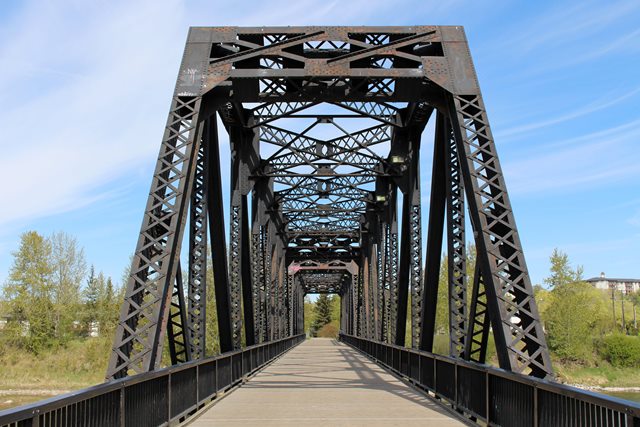
This bridge was built in 1908 and is a two-span Pratt through truss. It carried rail traffic until 1990 and is now part of the pedestrian network of the Waskasoo Park system within the City of Red Deer. It was designated as a Municipal Historic Resource by the City of Red Deer in 1991 and added to the Canadian Register of Historic Places in 2004. Lengths given are rough estimates.

Information and Findings From Alberta Register of Historic Places

Discussion of Bridge

HERITAGE SIGNIFICANCE

The Alberta Central Railway (ACR) Company was incorporated in May 1901 by the Dominion Government. The president of the company, John T. Moore, was a Toronto chartered accountant, businessman and alderman. Among his various business interests was the Saskatchewan Land and Homestead Company that had extensive holdings in the Red Deer area. Originally the ACR was to run from 'Coal Banks', through Red Deer to a location near Rocky Mountain House. Its charter was later revised to permit extension west to the Fraser valley via the Yellowhead Pass and east to Moose Jaw. The purpose of the railway was to develop central Alberta in general and the land owned by the Saskatchewan Land and Homestead Company in particular.

Shortage of capital delayed construction until the spring of 1910 when surveys were done for the line between Red Deer and Rocky Mountain House. In 1911, a continued lack of capital and competition from the Canadian Northern Railway (CNoR) forced Moore and his associated to lease the railway to the Canadian Pacific Railway (CPR). In 1914 the CPR completed the line to Rocky Mountain House. No further construction west of Rocky Mountain House or east of Red Deer was undertaken.

The Alberta Central Railway played a role in the economic development of the region west of Red Deer. Particularly in the agricultural settlement of this area, as was intended by its original promoters. It also played a limited role in the development of the coal reserves in the Nordegg area. A portion of the coal mined at Nordegg was transported to market via the Alberta Central Railway under an agreement with the Canadian Northern Railway.

Bridge Considered Historic By Survey: Yes

Divider

Photo Galleries and Videos: Red Deer River Railway Bridge


View Photo Gallery

Bridge Photo-Documentation

Original / Full Size Photos
A collection of overview and detail photos. This gallery offers photos in the highest available resolution and file size in a touch-friendly popup viewer.
Alternatively, Browse Without Using Viewer

Divider

View Photo Gallery

Bridge Photo-Documentation

Mobile Optimized Photos
A collection of overview and detail photos. This gallery features data-friendly, fast-loading photos in a touch-friendly popup viewer.
Alternatively, Browse Without Using Viewer

Divider

Maps and Links: Red Deer River Railway Bridge

Coordinates (Latitude, Longitude):

Search For Additional Bridge Listings:

HistoricBridges.org Bridge Browser: View listed bridges within 0.5 miles (0.8 kilometers) of this bridge.

HistoricBridges.org Bridge Browser: View listed bridges within 10 miles (16 kilometers) of this bridge.

Additional Maps:

Google Maps

Google Streetview (If Available)

Bing Maps

OpenStreetMap

GeoHack (Additional Links and Coordinates)

Apple Maps (Via DuckDuckGo Search)

Apple Maps (Apple devices only)

MapQuest

HERE We Go Maps

ACME Mapper

Waze Map

Android: Open Location In Your Map or GPS App

Flickr Gallery (Find Nearby Photos)

Wikimedia Commons (Find Nearby Photos)

Directions Via Sygic For Android

Directions Via Sygic For iOS and Android Dolphin Browser


Divider
 
Home Top

Divider

About - Contact

© Copyright 2003-2024, HistoricBridges.org. All Rights Reserved. Disclaimer: HistoricBridges.org is a volunteer group of private citizens. HistoricBridges.org is NOT a government agency, does not represent or work with any governmental agencies, nor is it in any way associated with any government agency or any non-profit organization. While we strive for accuracy in our factual content, HistoricBridges.org offers no guarantee of accuracy. Information is provided "as is" without warranty of any kind, either expressed or implied. Information could include technical inaccuracies or errors of omission. Opinions and commentary are the opinions of the respective HistoricBridges.org member who made them and do not necessarily represent the views of anyone else, including any outside photographers whose images may appear on the page in which the commentary appears. HistoricBridges.org does not bear any responsibility for any consequences resulting from the use of this or any other HistoricBridges.org information. Owners and users of bridges have the responsibility of correctly following all applicable laws, rules, and regulations, regardless of any HistoricBridges.org information.

Admin Login

Divider