

View Information About HSR Ratings
Disclaimer: Generated with the aid of ChatGPT AI, the below narrative is based on sources provided by Nathan Holth and crafted to align with his research and passion for historic bridges.
Nestled in the rugged landscape of northern Arizona, the Cameron Suspension Bridge stands as an enduring testament to early 20th-century engineering ingenuity. Built in 1911, this bridge was a pioneering structure that played a vital role in connecting the remote regions of northeastern Arizona, including the Navajo and Hopi Reservations, to the state’s transportation network. More than a simple crossing, the bridge symbolizes the development of infrastructure in Arizona’s territorial period, the challenges of constructing long-span bridges in the American Southwest, and the evolution of suspension bridge engineering in the United States. Today, though it no longer serves vehicular traffic, the Cameron Suspension Bridge remains one of the most historically and technologically significant bridges in Arizona, reflecting both a unique hybrid structural design and a crucial part of the region’s history.
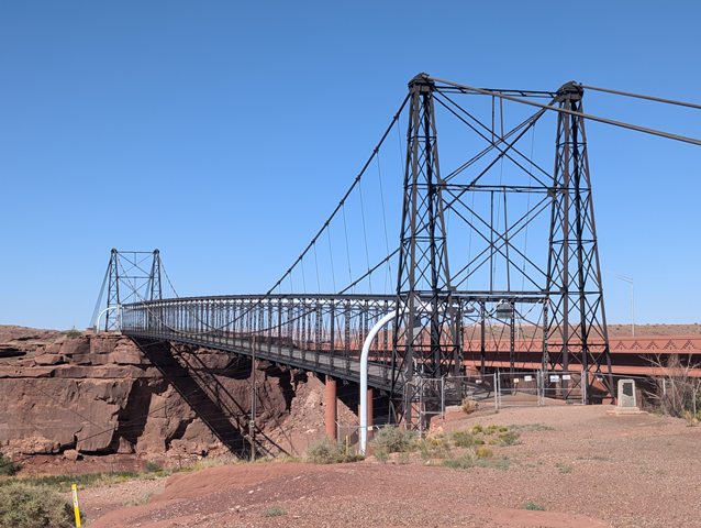
One of the most fascinating aspects of the Cameron Suspension Bridge is its unique hybrid structural design. While suspension bridges were already being built in the United States by the late 19th century, they were relatively rare in the desert Southwest, where engineers typically favored truss bridges due to their reliability and ease of construction. However, at Cameron, the Little Colorado River Gorge presented a significant challenge: the deep, rugged terrain made traditional construction methods impractical. Erecting bridge piers in the riverbed was not feasible, necessitating a long-span solution.
To meet this challenge, engineers combined a 660-foot-long suspension span with a Pratt through-truss design, making it the only example of this hybrid configuration in Arizona. The bridge’s suspension system consists of seven two-and-a-quarter-inch steel strands, which are clamped together to form a single main cable that supports the truss deck from above. These cables are anchored into massive eye-bars embedded in the solid rock on either side of the canyon. The stiffening truss provided additional strength, helping to counteract lateral forces and making the bridge more stable against high winds—a crucial consideration in an exposed desert landscape.
This combination of suspension and truss elements was both innovative and necessary, as it allowed the bridge to span a wide gap without requiring excessive materials or complex falsework, which would have been extremely difficult given the region’s terrain. This structural ingenuity would later influence the design of the McPhaul Suspension Bridge, built in 1928 near Yuma, Arizona, which also incorporated a suspension span with an internal stiffening truss.
The Cameron Suspension Bridge played a crucial role in the economic and infrastructural development of northern Arizona. At the time of its construction, travel in the region was severely limited by natural barriers, particularly the Little Colorado River, which made transportation between the Navajo and Hopi Reservations and the rest of the state difficult. The Office of Indian Affairs, recognizing the need for improved transportation and economic opportunities for indigenous communities, initiated the construction of the bridge.
The Midland Bridge Company of Kansas City, Missouri, was awarded the contract, and in 1911, the Cameron Suspension Bridge was completed. Named after Senator Ralph Cameron, a prominent Arizona politician and early advocate for infrastructure projects in the state, the bridge immediately transformed transportation in the region. It provided a vital link between Flagstaff and northeastern Arizona, facilitating trade, communication, and movement of goods. The agricultural products from Tuba City and the Moenkopi Plateau could now reach markets more efficiently, while supplies and materials could be transported into the region with greater ease.
Beyond local significance, the bridge also played a critical role in the development of the Grand Canyon tourism industry. Before the construction of more modern roads and bridges, the Cameron Suspension Bridge was one of the key crossings that allowed early automobile tourists to venture into northern Arizona and access the Grand Canyon from the east. This, in turn, contributed to the expansion of tourism in the region, reinforcing Arizona’s economic growth in the early 20th century.
While the Cameron Suspension Bridge was an engineering success, it faced significant structural challenges over its decades of use. In 1927, just 16 years after its construction, the bridge’s original wooden decking had to be replaced to accommodate heavier loads, particularly the transport of materials for the construction of the Navajo Bridge over the Colorado River, which would later become one of Arizona’s most famous crossings.
In 1936, further modifications were made to reinforce the structure. The wooden deck was replaced again, and additional deck stringers were installed to better support heavy traffic loads. Despite these improvements, an unusual incident in 1937 nearly brought disaster: a sheep jam. A massive herd of sheep crossing the bridge caused an overload that forced the suspension cables to slip between one to five inches at all cable clamps. Engineers had to jack the cables back into position and install additional safety clamps to prevent a similar event in the future.
By the late 1950s, the increasing demands of modern transportation necessitated a replacement. In 1958, a new bridge was constructed immediately to the east, and the Cameron Suspension Bridge was retired from vehicular use. However, rather than being abandoned entirely, it was repurposed for a new role.
Today, the Cameron Suspension Bridge remains standing, though its role has changed significantly. In 1958, following its closure to traffic, the bridge was sold to the Four Corners Pipeline Company and converted into a pipeline bridge. A 16-inch oil pipeline was installed, suspended beneath the truss, making use of the bridge’s existing structural framework to transport crude oil across the Little Colorado River. The bridge is now completely closed to the public, with chain-link fencing and barbed wire at both ends to prevent unauthorized access.
Despite its restricted access, the bridge retains much of its original structural integrity, with its towers, suspension cables, and truss elements intact. While the presence of the pipeline alters the bridge’s visual appearance, it does not significantly diminish its historical and engineering significance.
Although the Cameron Suspension Bridge is no longer open to the public, its historical and technological value is undeniable. As the oldest surviving highway suspension bridge in Arizona, it represents an important chapter in the state’s transportation history. It also highlights the innovative engineering solutions developed to overcome the region’s challenging geography.
The bridge’s continued existence raises important questions about the preservation of historic infrastructure. Unlike many other historic bridges, which face the threat of demolition due to obsolescence, the Cameron Suspension Bridge has been repurposed for industrial use, ensuring its structural maintenance. However, should the pipeline ever be decommissioned, the future of the bridge could be in jeopardy. Without an active function, it could fall into disrepair or face removal.
As advocates for historic bridges, we should consider the potential for future preservation efforts. Could the bridge be stabilized and reopened as a historic landmark? Might an interpretive center or pedestrian walkway be feasible? These are questions worth exploring, as the Cameron Suspension Bridge represents an irreplaceable piece of Arizona’s transportation heritage.
The Cameron Suspension Bridge is more than just a relic of Arizona’s past—it is a testament to early engineering ingenuity, the expansion of transportation infrastructure, and the adaptation of bridges for evolving uses. As one of the few remaining suspension bridges from Arizona’s territorial period, it holds an important place in the history of American bridge-building. Whether viewed through the lens of structural engineering, transportation history, or economic development, the bridge’s legacy is undeniable. Though it no longer serves its original purpose, its survival as a pipeline bridge ensures that it continues to function—a fate far better than outright demolition.
For historic bridge enthusiasts, the Cameron Suspension Bridge serves as a compelling example of why preserving these structures matters. It is a bridge worth remembering, studying, and, perhaps one day, restoring to a more publicly accessible role in Arizona’s history.
![]()
![]()
![]()
Coordinates (Latitude, Longitude):
Search For Additional Bridge Listings:
Bridgehunter.com: View listed bridges within 0.5 miles (0.8 kilometers) of this bridge.
Bridgehunter.com: View listed bridges within 10 miles (16 kilometers) of this bridge.
Additional Maps:
Google Streetview (If Available)
GeoHack (Additional Links and Coordinates)
Apple Maps (Via DuckDuckGo Search)
Apple Maps (Apple devices only)
Android: Open Location In Your Map or GPS App
Flickr Gallery (Find Nearby Photos)
Wikimedia Commons (Find Nearby Photos)
Directions Via Sygic For Android
Directions Via Sygic For iOS and Android Dolphin Browser
USGS National Map (United States Only)
Historical USGS Topo Maps (United States Only)
Historic Aerials (United States Only)
CalTopo Maps (United States Only)

© Copyright 2003-2026, HistoricBridges.org. All Rights Reserved. Disclaimer: HistoricBridges.org is a volunteer group of private citizens. HistoricBridges.org is NOT a government agency, does not represent or work with any governmental agencies, nor is it in any way associated with any government agency or any non-profit organization. While we strive for accuracy in our factual content, HistoricBridges.org offers no guarantee of accuracy. Information is provided "as is" without warranty of any kind, either expressed or implied. Information could include technical inaccuracies or errors of omission. Opinions and commentary are the opinions of the respective HistoricBridges.org member who made them and do not necessarily represent the views of anyone else, including any outside photographers whose images may appear on the page in which the commentary appears. HistoricBridges.org does not bear any responsibility for any consequences resulting from the use of this or any other HistoricBridges.org information. Owners and users of bridges have the responsibility of correctly following all applicable laws, rules, and regulations, regardless of any HistoricBridges.org information.
![]()