

View Information About HSR Ratings
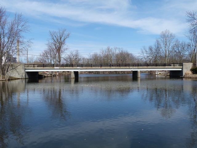
This is a three span steel stringer bridge located in Eaton Rapids. Eaton Rapids is one of those towns that has taken care of most of its bridges and today has a number of historic bridges in town and these bridge are also in good condition. This bridge is perhaps not the most significant of the old bridges in Eaton Rapids, but is still a nice looking bridge. It as the standard railings that were seen on bridges built from the late 1930s through the early 1960s, however these having the uncommon variation of having steel railing posts rather than concrete posts which are more common. The railings have been recently painted, but not before a number of decorative steel strips on the railing posts had a chance to rust and fall off. Plaques remain on the bridge, crediting the structure as a Federal Aid Secondary Project. Just about every level of government is listed: the Federal Government, State Highway Department, County Road Commission, and City of Eaton Rapids. The bridge was built in 1955 with Raff and Dexter listed as the contractors.
The previous bridge at this location was a two-span Warren pony truss with riveted connections. A short distance west of this bridge, there also was once a pin-connected through truss. Documented by Historic American Engineering Record, this beautiful historic bridge was replaced in more recent years.

![]()
![]()
![]()
Coordinates (Latitude, Longitude):
Search For Additional Bridge Listings:
Bridgehunter.com: View listed bridges within 0.5 miles (0.8 kilometers) of this bridge.
Bridgehunter.com: View listed bridges within 10 miles (16 kilometers) of this bridge.
Additional Maps:
Google Streetview (If Available)
GeoHack (Additional Links and Coordinates)
Apple Maps (Via DuckDuckGo Search)
Apple Maps (Apple devices only)
Android: Open Location In Your Map or GPS App
Flickr Gallery (Find Nearby Photos)
Wikimedia Commons (Find Nearby Photos)
Directions Via Sygic For Android
Directions Via Sygic For iOS and Android Dolphin Browser
USGS National Map (United States Only)
Historical USGS Topo Maps (United States Only)
Historic Aerials (United States Only)
CalTopo Maps (United States Only)

© Copyright 2003-2025, HistoricBridges.org. All Rights Reserved. Disclaimer: HistoricBridges.org is a volunteer group of private citizens. HistoricBridges.org is NOT a government agency, does not represent or work with any governmental agencies, nor is it in any way associated with any government agency or any non-profit organization. While we strive for accuracy in our factual content, HistoricBridges.org offers no guarantee of accuracy. Information is provided "as is" without warranty of any kind, either expressed or implied. Information could include technical inaccuracies or errors of omission. Opinions and commentary are the opinions of the respective HistoricBridges.org member who made them and do not necessarily represent the views of anyone else, including any outside photographers whose images may appear on the page in which the commentary appears. HistoricBridges.org does not bear any responsibility for any consequences resulting from the use of this or any other HistoricBridges.org information. Owners and users of bridges have the responsibility of correctly following all applicable laws, rules, and regulations, regardless of any HistoricBridges.org information.
![]()