HistoricBridges.org Menu: HistoricBridges.org Menu:


We Recommend:
Bach Steel - Experts at historic truss bridge restoration.

HistoricBridges.org: Bridge Browser

Masters Road Bridge

Masters Road Bridge

Primary Photographer(s): Nathan Holth

Bridge Documented: July 22, 2003 - Spring 2007

View Photos
and Videos
View Maps
and Links

Facility Carried / Feature Intersected
Masters Road Over Belle River
Location
Rural: St. Clair County, Michigan: United States
Construction Date and Builder / Engineer
1935 By Builder/Contractor: J. H. Baker and Sons of Port Huron, Michigan
Rehabilitation Date
Not Available or Not Applicable
Main Span Length
54.8 Feet (16.7 Meters)
Structure Length
57.7 Feet (17.6 Meters)
Roadway Width
20 Feet (6.1 Meters)
Spans
1 Main Span(s)
Inventory Number
77200022000B010

Historic Significance Rating (HSR)
View Information About HSR Ratings

Bridge Documentation

View Archived National Bridge Inventory Report - Has Additional Details and Evaluation

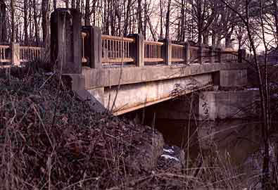
Although not as beautiful as a through truss bridge, this bridge is still a historic bridge, and should be given at least some mention. This bridge is a depression bridge, built in 1935, with the aid of federal relief funds. People into antiques value depression glass, and similarly depression bridges have additional value because they both document a key period in history, and also are a memorial to the hard times that a lot of people suffered through.

This bridge does not have an enormous amount of aesthetic value, beyond the guardrails. The guardrails themselves are quite attractive, which curve onto the bridge at each end. These guardrails have not been maintained and are severely rusted. St. Clair County Road Commission managed to take this problem and make it worse, by only plastering double-wide Armco metal guardrails all over the whole bridge, and doing no work to the historic railings.

Cobblestone abutments are visible behind the current concrete abutments. These supported a pony truss, which the current bridge replaced.

Information and Findings From Michigan Historic Bridge Inventory

Narrative Description

MDOT Historic Bridge St. Clair CountyMasters Rd. / Belle River

St. Clair County was hit hard by the Depression. The county's road commission aggressively sought federal relief funds for road and bridge work to put unemployed laborers back to work and improve the county's deteriorating road system. The resulting bridges, usually common structural types, sometimes displayed nonstandard detailing on railings and wing walls. Many of these structures have been demolished or altered since that time. The Masters Road Bridge merits National Register designation as a well-preserved, representative example of bridges produced by Depression-era relief programs.

On 6 September 1934, the St. Clair County Road Commission opened bids for the construction of a bridge over the Belle River one-half mile east of Riley Center. Plans for the new bridge were approved by William Cox, who served as the county road engineer from 1919 to 1938. The structure was to replace a 50-foot-span pony truss, which was supported by stone abutments. Three contractors, all from Port Huron, submitted bids: J.H. Baker and Sons, $9,391; George Willits, $9,951; and the Yeager Bridge and Culvert Company, $9,959.

The contract went to the low bidder, J.H. Baker and Sons. The firm had previously undertaken a large project for the county, the paving of Gratiot Road from Port Huron to the county line. The county had received a $279,300 contract from the state highway department for this project in January 1932, which it subcontracted to Baker. The road commission took on the project, in part, to provide work for the large number of unemployed men in St. Clair County.

In March 1933, with the same motivation, the county initiated a major effort to improve some 400 miles of township roads for which it was assuming responsibility under the provisions of the McNitt Act. In July of that year, the road commission applied for a $500,000 loan and grant through the National Industrial Recovery Act. Although it is not known if that amount was received, the road commission clearly had a substantial infusion of funds when it embarked on a flurry of bridge construction in the mid-1930s. Like the road improvements, the bridge work was also prompted by the poor condition of many township structures that the county received through the McNitt Act. The Masters Road Bridge is a representative example of that effort. The structure's design, although simple, reflects the streamlined aesthetic that dominated the 1930s.


This bridge is tagged with the following special condition(s): Unorganized Photos

Divider

Photo Galleries and Videos: Masters Road Bridge


View Photo Gallery

Bridge Photo-Documentation

A collection of overview and detail photos. This photo gallery contains a combination of Original Size photos and Mobile Optimized photos in a touch-friendly popup viewer.
Alternatively, Browse Without Using Viewer

Divider

View Photo Gallery

Additional Unorganized Photos

Original / Full Size Photos
This photo gallery features older ca. 2003-2006 photos taken when the website only included a few photos in original size on the website, and a smaller quantity of reduced size photos as well. This unorganized gallery may partially duplicate photos in other galleries on this bridge's page, however all photos here are available in the Original / Full Size. This gallery offers photos in the highest available resolution and file size in a touch-friendly popup viewer.
Alternatively, Browse Without Using Viewer

Divider

View Photo Gallery

Additional Unorganized Photos

Mobile Optimized Photos
This photo gallery features older ca. 2003-2006 photos taken when the website only included a few photos in original size on the website, and a smaller quantity of reduced size photos as well. This unorganized gallery may partially duplicate photos in other galleries on this bridge's page, however all photos here are available in the Original / Full Size. This gallery features data-friendly, fast-loading photos in a touch-friendly popup viewer.
Alternatively, Browse Without Using Viewer

Divider

Maps and Links: Masters Road Bridge

Coordinates (Latitude, Longitude):

Search For Additional Bridge Listings:

Bridgehunter.com: View listed bridges within 0.5 miles (0.8 kilometers) of this bridge.

Bridgehunter.com: View listed bridges within 10 miles (16 kilometers) of this bridge.

HistoricBridges.org Bridge Browser: View listed bridges within 0.5 miles (0.8 kilometers) of this bridge.

HistoricBridges.org Bridge Browser: View listed bridges within 10 miles (16 kilometers) of this bridge.

2021 National Bridge Inventory: View listed bridges within 0.5 miles (0.8 kilometers) of this bridge.

Additional Maps:

Google Maps

Google Streetview (If Available)

Bing Maps

OpenStreetMap

GeoHack (Additional Links and Coordinates)

Apple Maps (Via DuckDuckGo Search)

Apple Maps (Apple devices only)

MapQuest

HERE We Go Maps

ACME Mapper

Waze Map

Android: Open Location In Your Map or GPS App

Flickr Gallery (Find Nearby Photos)

Wikimedia Commons (Find Nearby Photos)

Directions Via Sygic For Android

Directions Via Sygic For iOS and Android Dolphin Browser

USGS National Map (United States Only)

Historical USGS Topo Maps (United States Only)

Historic Aerials (United States Only)

CalTopo Maps (United States Only)


Divider
 
Home Top

Divider

About - Contact

© Copyright 2003-2024, HistoricBridges.org. All Rights Reserved. Disclaimer: HistoricBridges.org is a volunteer group of private citizens. HistoricBridges.org is NOT a government agency, does not represent or work with any governmental agencies, nor is it in any way associated with any government agency or any non-profit organization. While we strive for accuracy in our factual content, HistoricBridges.org offers no guarantee of accuracy. Information is provided "as is" without warranty of any kind, either expressed or implied. Information could include technical inaccuracies or errors of omission. Opinions and commentary are the opinions of the respective HistoricBridges.org member who made them and do not necessarily represent the views of anyone else, including any outside photographers whose images may appear on the page in which the commentary appears. HistoricBridges.org does not bear any responsibility for any consequences resulting from the use of this or any other HistoricBridges.org information. Owners and users of bridges have the responsibility of correctly following all applicable laws, rules, and regulations, regardless of any HistoricBridges.org information.

Admin Login

Divider