HistoricBridges.org Menu: HistoricBridges.org Menu:


We Recommend:
Bach Steel - Experts at historic truss bridge restoration.

HistoricBridges.org: Bridge Browser

Agassiz-Rosedale Bridge

Agassiz-Rosedale Bridge

Primary Photographer(s): Nathan Holth

Bridge Documented: August 26, 2014

View Photos
and Videos
View Maps
and Links

Facility Carried / Feature Intersected
BC-9 (Agassiz-Rosedale Highway) Over Fraser River
Location
Rural: Fraser Valley District, British Columbia: Canada
Structure Type
Metal Cantilever (Arched) 16 Panel Rivet-Connected Polygonal Warren Through Truss, Fixed and Approach Spans: Metal 14 Panel Rivet-Connected Warren Deck Truss, Fixed
Construction Date and Builder / Engineer
1956 By Builder/Contractor: Dominion Bridge Company of Montréal, Québec and Engineer/Design: C. K. Saunders
Rehabilitation Date
Not Available or Not Applicable
Main Span Length
365.0 Feet (111.3 Meters)
Structure Length
6,130.0 Feet (1868.4 Meters)
Roadway Width
Not Available
Spans
3 Main Span(s)
Inventory Number
Not Applicable

Historic Significance Rating (HSR)
View Information About HSR Ratings

Bridge Documentation

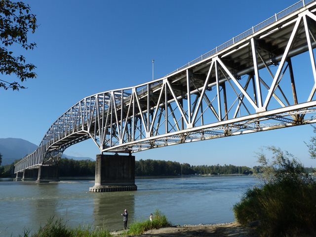
This bridge is a large and impressive example of an uncommon but aesthetically pleasing bridge type, the cantilever truss bridge with an arched truss shape. This rare variety of cantilever features a deck truss that transitions into a through truss for the navigation channel, providing more clearance for boats. The design also eliminates the towers associated with typical cantilever through truss bridges and has a carefully concealed suspended span, all of which provides a very graceful looking truss.

This particular bridge also features an extremely long approach system, including numerous simple deck truss spans, as well as a very large number of steel stringer spans. The northern approach is particularly long, and includes a section that runs at an even, low elevation over flood plain.

The plaque on the bridge references the British Columbia Toll Highways and Bridges Authority, suggesting this bridge was originally a toll bridge.

Northern Construction Company and J.W. Stewart Limited, Western Bridge and Steel Fabricators Limited, and Dominion Bridge Company Limited were all listed as contractors for the bridge.

Divider

Photo Galleries and Videos: Agassiz-Rosedale Bridge


View Photo Gallery

Structure Overview

Original / Full Size Photos
A collection of overview photos that show the bridge as a whole and general areas of the bridge. This gallery offers photos in the highest available resolution and file size in a touch-friendly popup viewer.
Alternatively, Browse Without Using Viewer

Divider

View Photo Gallery

Structure Details

Original / Full Size Photos
A collection of detail photos that document the parts, construction, and condition of the bridge. This gallery offers photos in the highest available resolution and file size in a touch-friendly popup viewer.
Alternatively, Browse Without Using Viewer

Divider

View Photo Gallery

Structure Overview

Mobile Optimized Photos
A collection of overview photos that show the bridge as a whole and general areas of the bridge. This gallery features data-friendly, fast-loading photos in a touch-friendly popup viewer.
Alternatively, Browse Without Using Viewer

Divider

View Photo Gallery

Structure Details

Mobile Optimized Photos
A collection of detail photos that document the parts, construction, and condition of the bridge. This gallery features data-friendly, fast-loading photos in a touch-friendly popup viewer.
Alternatively, Browse Without Using Viewer

Divider

View Video

CarCam: Northbound Crossing

Full Motion Video
Note: The downloadable high quality version of this video (available on the video page) is well worth the download since it offers excellent 1080 HD detail and is vastly more impressive than the compressed streaming video. Streaming video of the bridge. Also includes a higher quality downloadable video for greater clarity or offline viewing.

Divider

Maps and Links: Agassiz-Rosedale Bridge

Coordinates (Latitude, Longitude):

Search For Additional Bridge Listings:

HistoricBridges.org Bridge Browser: View listed bridges within 0.5 miles (0.8 kilometers) of this bridge.

HistoricBridges.org Bridge Browser: View listed bridges within 10 miles (16 kilometers) of this bridge.

Additional Maps:

Google Maps

Google Streetview (If Available)

Bing Maps

OpenStreetMap

GeoHack (Additional Links and Coordinates)

Apple Maps (Via DuckDuckGo Search)

Apple Maps (Apple devices only)

MapQuest

HERE We Go Maps

ACME Mapper

Waze Map

Android: Open Location In Your Map or GPS App

Flickr Gallery (Find Nearby Photos)

Wikimedia Commons (Find Nearby Photos)

Directions Via Sygic For Android

Directions Via Sygic For iOS and Android Dolphin Browser


Divider
 
Home Top

Divider

About - Contact

© Copyright 2003-2024, HistoricBridges.org. All Rights Reserved. Disclaimer: HistoricBridges.org is a volunteer group of private citizens. HistoricBridges.org is NOT a government agency, does not represent or work with any governmental agencies, nor is it in any way associated with any government agency or any non-profit organization. While we strive for accuracy in our factual content, HistoricBridges.org offers no guarantee of accuracy. Information is provided "as is" without warranty of any kind, either expressed or implied. Information could include technical inaccuracies or errors of omission. Opinions and commentary are the opinions of the respective HistoricBridges.org member who made them and do not necessarily represent the views of anyone else, including any outside photographers whose images may appear on the page in which the commentary appears. HistoricBridges.org does not bear any responsibility for any consequences resulting from the use of this or any other HistoricBridges.org information. Owners and users of bridges have the responsibility of correctly following all applicable laws, rules, and regulations, regardless of any HistoricBridges.org information.

Admin Login

Divider