We Recommend:
Bach Steel - Experts at historic truss bridge restoration.
BridgeHunter.com Phase 1 is released to the public! - Visit Now
3rd Street Bridge
Lefty O'Doul Bridge

Primary Photographer(s): Nathan Holth
Bridge Documented: April 4, 2013
San Francisco: San Francisco County, California: United States
Metal Rivet-Connected Pratt Through Truss, Movable: Single Leaf Bascule (Heel Trunnion) and Approach Spans: Concrete T-Beam, Fixed
1933 By Builder/Contractor: Barrett and Hilp of San Francisco, California and Engineer/Design: Strauss Bascule Bridge Company (Strauss Engineering Company) of Chicago, Illinois
Not Available or Not Applicable
143.0 Feet (43.6 Meters)
295.0 Feet (89.9 Meters)
71.5 Feet (21.79 Meters)
1 Main Span(s) and 5 Approach Span(s)
34C0025

View Information About HSR Ratings
Bridge Documentation
View Archived National Bridge Inventory Report - Has Additional Details and Evaluation
View Historic Bridge Inventory Sheet For This Bridge
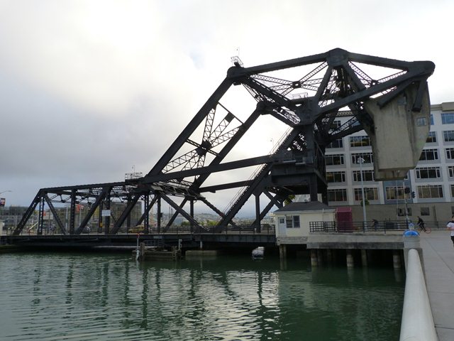
This bridge is a good example of a Strauss heel-trunnion bascule bridge. The bridge type with its distinctive parallelogram of links connecting counterweight and main trunnions was invented by Joseph Strauss, and this bridge was designed by his company. This particular example is unusual because it has a roadway that not only occupies the space between truss lines, but also has a roadway that is cantilevered out from the western truss line. Barrett and Hilp of San Francisco, California were the contractors for the bridge, with Moore Dry Dock Company also listed as playing a role in building the bridge.
Information About John Francis Barrett John Francis Barrett, descendant of one of the pioneer families of San Francisco, is now a member of the contracting firm of Barrett & Hilp, rated among the leaders in the building business of the bay
district. Mr. Barrett was born November 19, 1888, at Buchanan and Fell streets in San Francisco, in that district known as Hayes Valley. He is a son of John J. and Margaret (McMahon) Barrett. The father came to San Francisco in 1878
and here followed his trade as a building contractor, having constructed many of the finest residences of that period. He settled in the Sunnyside district, and was about the first one to build there. He was quite active in civic
affairs, and in that district organized the first improvement club. His death occurred in the year 1926. His wife, whom he married in San Francisco, was a native of Memphis, Tennessee, and came to this city as a young girl. They
became the parents of six sons and four daughters, all of whom, with their mother, survive the father. Source: Byington, Lewis Francis, �History of San Francisco 3 Vols�, S. J. Clarke Publishing Co., Chicago, 1931. Vol. 3 Pages 109-111. |
![]()
Photo Galleries and Videos: 3rd Street Bridge
Bridge Photo-Documentation
Original / Full Size PhotosA collection of overview and detail photos. This gallery offers photos in the highest available resolution and file size in a touch-friendly popup viewer.
Alternatively, Browse Without Using Viewer
![]()
Bridge Photo-Documentation
Mobile Optimized PhotosA collection of overview and detail photos. This gallery features data-friendly, fast-loading photos in a touch-friendly popup viewer.
Alternatively, Browse Without Using Viewer
![]()
CarCam: Northbound Crossing
Full Motion VideoNote: The downloadable high quality version of this video (available on the video page) is well worth the download since it offers excellent 1080 HD detail and is vastly more impressive than the compressed streaming video. Streaming video of the bridge. Also includes a higher quality downloadable video for greater clarity or offline viewing.
![]()
CarCam: Southbound Crossing
Full Motion VideoNote: The downloadable high quality version of this video (available on the video page) is well worth the download since it offers excellent 1080 HD detail and is vastly more impressive than the compressed streaming video. Streaming video of the bridge. Also includes a higher quality downloadable video for greater clarity or offline viewing.
![]()
Maps and Links: 3rd Street Bridge
Coordinates (Latitude, Longitude):
Search For Additional Bridge Listings:
Bridgehunter.com: View listed bridges within 0.5 miles (0.8 kilometers) of this bridge.
Bridgehunter.com: View listed bridges within 10 miles (16 kilometers) of this bridge.
Additional Maps:
Google Streetview (If Available)
GeoHack (Additional Links and Coordinates)
Apple Maps (Via DuckDuckGo Search)
Apple Maps (Apple devices only)
Android: Open Location In Your Map or GPS App
Flickr Gallery (Find Nearby Photos)
Wikimedia Commons (Find Nearby Photos)
Directions Via Sygic For Android
Directions Via Sygic For iOS and Android Dolphin Browser
USGS National Map (United States Only)
Historical USGS Topo Maps (United States Only)
Historic Aerials (United States Only)
CalTopo Maps (United States Only)


