We Recommend:
Bach Steel - Experts at historic truss bridge restoration.
BridgeHunter.com Phase 1 is released to the public! - Visit Now
San Francisco Oakland Bay Bridge

Primary Photographer(s): Nathan Holth
Bridge Documented: April 9, 2013
San Francisco and Oakland: San Francisco County, California and Alameda County, California: United States
Metal Deck Truss Stiffening Wire Cable Suspension, Fixed and Approach Spans: Metal Cantilever Rivet-Connected Modified Warren Through Truss, Fixed
1936 By Builder/Contractor: American Bridge Company of New York, New York and Engineer/Design: Charles Henry Purcell, Charles E. Andrew, and Glen Woodruff
1962
2,310.0 Feet (704.1 Meters)
22,655.0 Feet (6905.2 Meters)
58 Feet (17.68 Meters)
9 Main Span(s) and 100 Approach Span(s)
330025

View Information About HSR Ratings
Bridge Documentation
View Archived National Bridge Inventory Report - Has Additional Details and Evaluation
View Historic American Engineering Record (HAER) Documentation For This Bridge
HAER Drawings, PDF - HAER Data Pages, PDF - HAER Original Plan Sheets, PDF
Half The Entire Eastern Half of This Historic Bridge Is Being Demolished Starting Fall 2013!
View Information About The Bay Bridge Demolition On The Official Project Website
View Historical Publication Discussing Bridge
View Various Historical Articles About The Bridge From California Highways and Public Works Magazine
View Historical Articles About This Bridge
Introduction To The San Francisco Oakland Bay Bridge

|
Excerpts From Historic American Engineering Record The San Francisco-Oakland Bay Bridge is one of the most impressive engineering structures in the United States. The bridge has been recognized by the American Society of Civil Engineers as a nationally significant structure from the standpoint of engineering as well as its importance in the transportation history of California and the nation. The Bay Bridge was the longest bridge in the world at the time it was built. It is also among the world's most complex bridges in that it incorporates a variety of different bridge types connected to form a single structure carrying two levels of traffic between San Francisco and Oakland, California. People may disagree as to whether the Bay Bridge is more important for its engineering, its role in transportation history or for its importance in the politics of the area. The structure is highly significant in all of these different ways. |
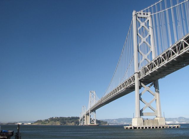
Completed one year before the Golden Gate Bridge, The San Francisco Oakland Bay Bridge, locally known as simply the Bay Bridge, is actually a complex system of unique and independent structures, with the largest features including suspension spans crossing the portion of the bay west of Yerba Buena Island, a tunnel on Yerba Buena Island, and cantilever truss spans east of Yerba Buena Island.
The Historic American Engineering Record found that the Bay Bridge transcended the world of bridges, instead describing it not only as one of the most important bridges in the country, but indeed one of the most impressive and significant structures of any kind in the entire country. No other bridge has been documented so extensively and completely by the HAER program, with the documentation containing over 400 photos, 20 drawings, and 273 data pages composing a written narrative that is essentially a full-size book on the history and design of the bridge. Those interested in a detailed history of this bridge are encouraged to view their documentation.
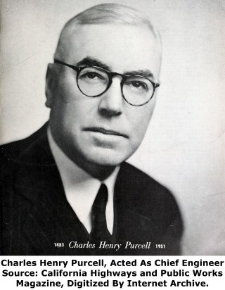
Unlike many large bridges built in the first half of the 20th Century, the lead design of this bridge was not undertaken by any of the well-known consulting engineers of the period, although some of these engineers did provide consultation and oversight. Instead, the bridge was essentially designed "in-house" by the State of California. The Chief Engineer for this bridge was Charles Henry Purcell. Charles E. Andrew acted as an assistant to Purcell. Andrew and Purcell relied heavily on Glenn Woodruff who acted as design engineer and was the only one of the three with substantial prior experience in large span bridge design. It is likely that a lot of the actual design work was done by Woodruff. As aforementioned, the bridge was essentially designed "in-house" however a Board of Consulting Engineers was appointed to provide oversight and input into the design process. One of the greatest bridge engineers of the 20th Century, Ralph Modjeski, was the chairman of the Board of Consulting Engineers. Leon Moisseiff another well-known bridge engineer, was also on the board. Numerous contractors were involved with various aspects of the construction of this bridge. Although other aspects of construction were equally or even more important, such as substructure construction, perhaps the most visible work, erection of the superstructure was erected by the American Bridge Company of New York, New York, which was also perhaps the most well-known and prolific of all involved contractors.
The exact configuration of this massive bridge has changed over the years due to various projects, particularly on the approaches to the bridge. Thus, exact bridge lengths and span numbers vary depending on the source consulted.
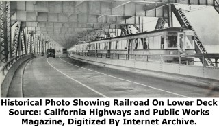
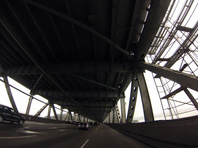
The bridge is an extremely wide bridge capable of carrying large volumes of traffic, and indeed it carries an enormous amount, with an Average Daily Traffic of 270,000. One of the uncommon features of the bridge that allows it to carry this amount of traffic is that it is a double-deck bridge. The upper level carries westbound traffic, while the the lower level carries eastbound traffic. Originally, the lower deck was divided and also was able to carry railroad traffic.
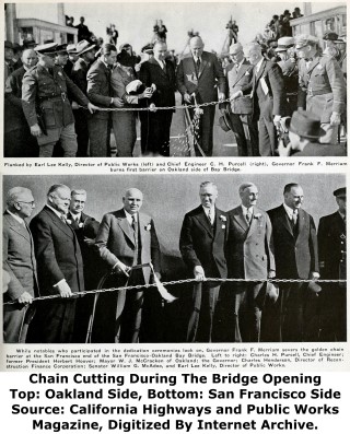
The bridge was too awesome of a bridge to lower itself to a mere ribbon cutting ceremony when it was opened to traffic. Instead, a golden chain was cut with an oxy-acetylene cutting torch to open the bridge at the San Francisco end of the bridge. A similar ceremony also took place at the Oakland end of the bridge.
An All American Bridge From 1936-2013. Half A Monument To China From 2014 Onward
California Department of Transportation (Caltrans), decided that the best way to deal with one of the most important historic bridges in the country was to demolish approximately half of the entire bridge (specifically the eastern bay spans) and replace them with mundane slabs of concrete held in place by a cable-stayed-like structure. This decision was made despite apparent alternatives that included rehabilitation and retrofit against seismic-related damage. The planned demolition of of half of the San Francisco Oakland Bay Bridge represents one of the greatest single losses of a historic resource in the modern history of the United States.
The original bridge was an all-American bridge... a structure built with American steel by the American Bridge Company. The replacement eastern bay spans in contrast are the pride of China. The United States apparently did not even have the ability to fabricate all the parts of the bridge. Many of the materials for this replacement bridge were outsourced to China. The replacement bridge will be a monument to the efforts and capability of China's work force and industry. It will also be a monument to how far the United States has sunk, a country no longer able to build a bridge over water that was bridged by American workers decades ago.
If the Western Spans and the Eastern Spans are considered two different bridges, their historic significance is nearly equal, each being an extremely significant bridge in its own right. However, together as a single bridge, they combine to form an even more significant bridge system. With the demolition of the eastern spans, the overall historic significance will be drastically reduced. The new bridge for the Eastern Spans will have no heritage value whatsoever, extremely limited (if any) aesthetic value, and it will bear no resemblance to the form and function of the historic spans. The Historic Significance Rating below reflects the significance of the bridge prior to the Eastern Spans demolition.
Details About The Western Spans (Suspension Spans)
| Western Spans (Suspension Spans) Technical Facts |
| Rehabilitation Date | Main Span Length | Tower Length (From Water Level) | Structure Length | Main Spans |
| 2003 | 2,310 Feet (704.1 Meters) | 526 Feet (160 Meters) | 9,620 Feet (2,932.2 Meters) | 6 |
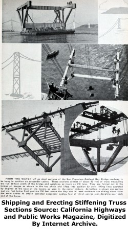
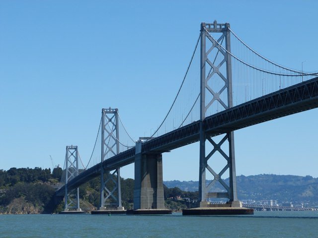
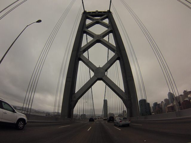
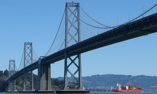
The Western Spans of the Bay Bridge are primarily composed of the six massive suspension spans of the Bay Bridge, stiffened by a riveted Warren truss system. Towers for the six suspension spans are composed of riveted steel, with an overall design that includes a massive lattice pattern of bracing between the tower posts.
From a historic and technological standpoint, the suspension spans are extremely unusual and technologically noteworthy because of their span configuration. Suspension bridges were generally designed for situations were the longest possible span over a massive feature was desired. As such, most suspension bridges have two towers that allow for a single massive central span between those two towers, just like the Golden Gate Bridge. However, the Western Spans contain four towers forming two central suspension spans and four arm suspension spans. In a sense, the bridge is like two traditionally composed suspension bridges lined up one right after the other. This configuration makes the Western Spans unique and distinctive, giving the bridge a strong sense of identity. The repeating, graceful curves of the suspension cables also give the bridge a high level of aesthetic value.
The Western Spans are the closest to busy San Francisco and they have traditionally been the most well-known and beloved by the general public due to the graceful appearance of the cables in the suspension bridge system as well as the impressive towers that hold those cables. The fact that they are closer to the metropolitan core city of San Francisco may have also added to their fame, since they are viewed by many tourists in the downtown area.
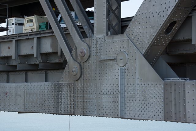
The Western Spans have been recently retrofitted and rehabilitated in conjunction with the project to demolish and replace the other half of the bridge. The retrofitting of the Western Spans of this bridge included the replacement of most of the v-lacing/lattice on the built-up beams composing the stiffening truss with perforated plate steel (the type commonly seen on 1950s and 1960s truss bridges). The HistoricBridges.org team has limited experience with the peculiarities of seismic retrofitting, but the question deserves to be asked if there might not have been another way to strengthen the stiffening truss beams without stripping the bridge of lattice and v-lacing, which are features that make the trusses more intricate and beautiful. In particular, it bears mentioning that the Golden Gate Bridge was retrofitted and rehabilitated without removing the extensive lattice and v-lacing present on its stiffening trusses.
Details About The Eastern Spans (Cantilever Truss Spans)

| Eastern Spans (Cantilever Truss Spans) Technical Facts |
| Demolition Date (Expected) | Central Cantilever Span Length | Cantilever Anchor Arm Span Length | Eastern Spans Total Structure Length | Main Spans |
| 2013 | 1,400 Feet (426.7 Meters) | 580 Feet (176.7 Meters) | 10,176 Feet (3101.6 Meters) | 3 |
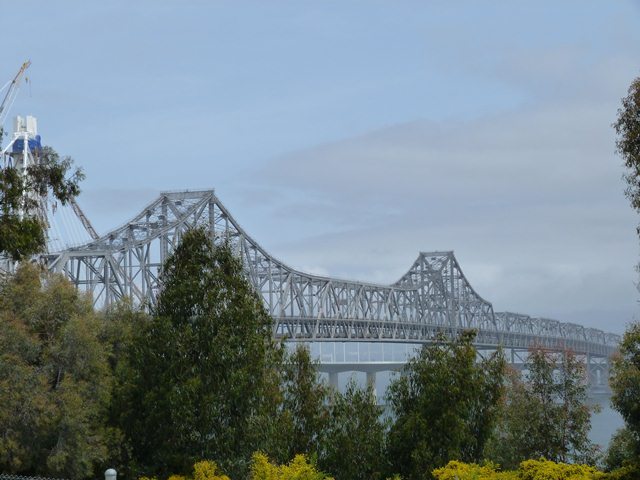
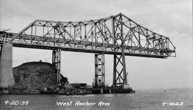
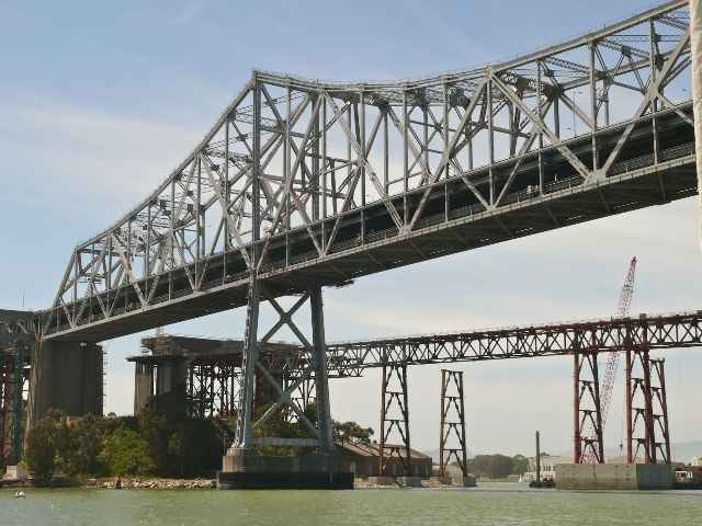
The Eastern Spans consist primarily of truss spans. The main feature is the enormous cantilever through truss structure which is an extremely important historic structure, and one of the most important examples of its type in the country. When it was built, it was the longest spanning and heaviest cantilever bridge in the United States. It remains among the longest spans ever built. Its overall composition is traditional in form, with two pointed towers, two anchor arm spans and a central span containing a suspended span. However there are some unique and distinctive details which the HAER documentation discusses.
There are also a series of through and deck truss spans on the Eastern Spans. The deck truss spans are Warren truss spans with riveted connections, while the through truss spans are modified (Baltimore style) Warren truss spans with riveted connections. The through truss spans are in fact individually historically significant on account of their length: each through truss span is 504 feet long, each containing 12 panels of 42 feet each. 504 feet is extremely long for a simple spanning, trapezoidal truss. Most through truss spans of this length, such as the 519 foot Brownsville Bridge (one of the largest truss spans in Pennsylvania) have a polygonal top chord, and as such are not trapezoidal trusses.
In the infamous 1989 Loma Prieta Earthquake, a single deck section failed on the Eastern Spans when some bolts sheared, causing the deck segment to crash down onto the lower deck, which in turn failed as well. While it was a tragic event that had fatalities, and it did point to a need to retrofit the bridge, the description of the event is often incorrectly described. Uninformed media and other individuals often wrongly describe this event as a partial bridge collapse. It was actually a deck collapse (and only a single deck span), the actual bridge superstructure remained intact, unlike the horrific collapse of the Cypress Street Viaduct in that same earthquake, in which both substructure and superstructure failure occurred.
The preference of the general public for the visual appearance of the suspension structure of the Western Spans is reflective of a general public who has failed to truly take a look at the Eastern Spans and appreciate the beauty contained within their design. The Eastern Spans may not have graceful curves or looming towers of a suspension bridge, yet they offer a different type of aesthetic which is an intricate geometric art which is formed from the complex arrangement of the trusses in the bridge, complimented by the lattice and v-lacing present on the built-up beams of the bridge.
Eastern Spans (Cantilever Truss Bridge) Demolition Plans
The San Francisco Oakland Bay Bridge does not apparently enjoy the protection and perpetual existence that the nearby Golden Gate Bridge seems to enjoy. Caltrans is currently building a replacement bridge for the Eastern Spans on a slightly new alignment. Following the completion of this new bridge, the entirety of the historic Eastern Spans will be demolished, resulting in the complete destruction of one half of a bridge that is one of the largest and most important bridges in the United States.
Cantilever truss bridges are one of the most threatened historic bridge types in the country. Since they are usually used on long crossings that are expensive to bridge, and as such only a limited number of long-span bridges being built, cantilever bridges tend to be regionally important crossings that carry much traffic, resulting in functional obsolescence and structural deficiencies. This fact has lead to widespread demolition of a population of bridges that was never very large to begin with. This enhanced by the United States' transportation funding system that tends to reward agencies who propose costly replacement projects rather then rehabilitation projects that often are actually less expensive when properly designed.
Could the Eastern Spans have been retrofitted and rehabilitated? It certainly seems so. Other old historic bridges both large and small from the 4th Street Bridge to the Golden Gate Bridge have been rehabilitated and retrofitted in the seismically active San Francisco Bay area. In particular, the nearby Richmond-San Rafael Bridge, which is also a cantilever truss span similar to the Eastern Spans of the Bay Bridge was successfully retrofitted. Also, although the Eastern Spans superstructure type is different, it is worth noting that the Western Spans were rehabilitated and retrofitted, again raising concerns that rehabilitation of the Eastern Spans might also have been feasible. Taylor Devices provided massive Seismic Dampers for the western spans. On the Taylor Devices website, it states that "You can now protect almost any new or existing structure against earthquakes, simply and inexpensively. Taylor Devices' Fluid Viscous Dampers provide complete protection for buildings, bridges, towers, elevated freeways; virtually any structure that is subject to earthquake damage. You can also protect sensitive equipment inside your building, like computers and generators. Taylor Dampers literally soak up the energy of earthquake induced motion, preventing structural damage. Compact, yet powerful, Taylor Fluid Viscous Dampers increase structural damping levels to as much as 50% of critical, the results being truly dramatic stress and deflection reduction." Perhaps similar dampers could have been installed on the eastern spans to make them safe against earthquakes.
Earthquakes do present a unique challenge with historic bridge preservation, as do bridges like the Bay Bridge which are busy and are critically essential components of a regional infrastructure. However if the engineers of the 21st Century, equipped with centuries of knowledge, as well as computers and other technology, have even a fraction of the creativity and ingenuity of the inventors and engineers of the 19th Century, then HistoricBridges.org is confident that a preservation solution for the Eastern Spans that was safe and fiscally reasonable could have and should have been developed. The solution might not have been a cookie cutter design, it probably would have required designing and trying some new approaches. Instead, a preservation solution would have continued the spirit of bold thinking that resulted in historic bridges like the Golden Gate Bridge and Bay Bridge in the first place. Even relocating and preserving a single through truss span appears to have been beyond the scope of consideration. By demolishing half of one of the largest, most complex, and historically significant manmade structures in the United States, built by Americans with American steel, with a bridge built from Chinese materials that cost more than any other bridge in California history and was fraught with construction and materials challenges, the loss and replacement of this bridge is a failure before the American people.
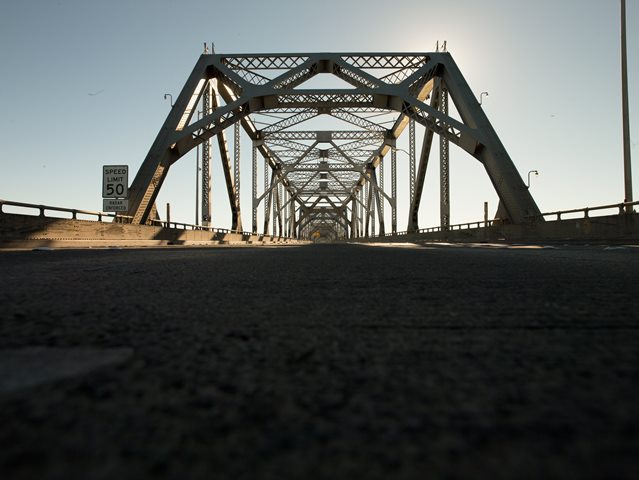
This demolition of the Eastern Spans will occur despite the fact that with the exception of a few deck truss spans which have already been demolished, the historic spans are not in the way of their replacement. However, possibilities for preserving either part or all the historic Eastern Spans next to the replacement bridge were not given serious consideration any more than possibilities for simply rehabilitating and retrofitting the historic spans for continued vehicular use. Even with a decision to build a new spans on a different alignment, some or all of the historic bridge could have been preserved as part of an adaptive reuse. In January 2010, a group came out with a very different and unique adaptive reuse of the historic Eastern Spans. This plan, as well as other plans for the reuse of bridge parts (such as displays in a park) either fell through or have been greatly reduced in scope. One group has formed however and seeks to salvage parts from the bridge to construction an eco-friendly housing and multi-use structure. Please view their website at baybridgehouse.org. HistoricBridges.org also wishes to thank David Grieshaber and Mike Koozmin of the BayBridgeHouse effort for sharing their high quality photos of the bridge taken as part of their development. Their photos, taken after the bridge was closed to traffic offer views from on the bridge and well as views from the walkway of the replacement bridge.
Eastern Spans (Cantilever Truss Bridge) Comments On Replacement Bridge
The replacement bridge type is as a self-anchored suspension bridge. Because of the self-anchored design, Caltrans thinks the bridge is something revolutionary and state of the art. However, a self-anchored suspension bridge presents nothing new or remarkable to the engineering world. After all, Pittsburgh has three self-anchored suspension bridges, which dating to the 1920s, are historic bridges and far more beautiful in appearance and more significant to the engineering world.
The new bridge has been touted by Caltrans as a "signature" span that has a high level of aesthetic value. While it may be true that the arrangement of the cables has a somewhat appealing expression of a modern architectural form, the overall aesthetics of the design is ruined by the use of massive amounts of plain concrete to form a relatively mundane deck. This extensive use of concrete (which is typical of most modern bridges) makes much of the bridge look like little more than a ugly concrete freeway viaduct. In addition, the modern appearance of the bridge will not fit with the historical appearance and design of the surrounding bridge structures, including the Golden Gate Bridge, the Western Spans, and even the Richmond-San Rafael Bridge. As such, the bridge will look inappropriate and out of place. Finally, although the structure type of the new bridge is a suspension bridge, the single tower configuration coupled with a main cable that slopes down at a sharp angle to a massive concrete deck, in truth makes the bridge look like little more than a modern cable-stayed bridge. Cable-stayed bridges are rapidly becoming the most common structure type in the country for long-span bridges, as the wide variety of large span historic bridge types in the country are being demolished and replaced with these modern bridges. As such, the new Eastern Spans bridge will have a general appearance that will be vastly similar to the countless mundane cable-stayed bridges that are covering the face of this country.
It is worth noting that for a variety of reasons, the new bridge has been controversial, particularly during the period in which alternatives and design types were being considered. There was even an entire website created by concerned individuals. Issues includes rising costs of building the bridge, as well as concerns about the seismic safety of the bridge. The new bridge design has since been certified to be seismically safe, yet at the same time it is questionable how much more protection the bridge actually offers versus a well-planned rehabilitation and retrofit of the historic spans, especially when considering other retrofitted historic bridges such as the Golden Gate Bridge.
About This Bridge's Public Photograph Compilation (PPC)
In addition to photos taken by HistoricBridges.org, the photo galleries for this bridge include two Public Photograph Compilations (PPCs), which are composed from select photos from public repositories like Flickr, and organized and combined into the familiar HistoricBridges.org photo gallery format. The photos are legally offered by HistoricBridges.org under the terms of a Creative Commons license. As required under the license, HistoricBridges.org hereby states that none of the photographers endorse HistoricBridges.org and its ideas, nor are they affiliated with HistoricBridges.org in any way. Learn more about HistoricBridges.org's Public Photograph Compilations here.
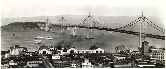
Above: Historical photo of bridge. Photo Courtesy: Jan Griggs
![]()
Photo Galleries and Videos: San Francisco Oakland Bay Bridge
West Spans Photo-Documentation
Original / Full Size PhotosA collection of overview and detail photos. This gallery offers photos in the highest available resolution and file size in a touch-friendly popup viewer.
Alternatively, Browse Without Using Viewer
![]()
East Spans Photo-Documentation
Original / Full Size PhotosA collection of overview and detail photos. This gallery offers photos in the highest available resolution and file size in a touch-friendly popup viewer.
Alternatively, Browse Without Using Viewer
![]()
Post-Closure East Spans Overview Photos
Original / Full Size PhotosTaken by David Grieshaber and Mike Koozmin after the bridge was closed to traffic, a collection of overview photos that show the bridge as a whole and general areas of the bridge. Photos taken from on the bridge and from the replacement bridge walkway. This gallery offers photos in the highest available resolution and file size in a touch-friendly popup viewer.
Alternatively, Browse Without Using Viewer
![]()
Post-Closure East Spans Detail Photos
Original / Full Size PhotosTaken by David Grieshaber and Mike Koozmin after the bridge was closed to traffic, a collection of detail photos that document the parts, construction, and condition of the bridge. Photos taken from on the bridge and from the replacement bridge walkway. This gallery offers photos in the highest available resolution and file size in a touch-friendly popup viewer.
Alternatively, Browse Without Using Viewer
![]()
Upper Deck Drive: Sunny Day
Original / Full Size PhotosA collection of photos taken with a wide angle GoPro camera showing the experiance of driving over the bridge. This gallery offers photos in the highest available resolution and file size in a touch-friendly popup viewer.
Alternatively, Browse Without Using Viewer
![]()
Upper Deck Drive: Cloudy Day
Original / Full Size PhotosA collection of photos taken with a wide angle GoPro camera showing the experiance of driving over the bridge. This gallery offers photos in the highest available resolution and file size in a touch-friendly popup viewer.
Alternatively, Browse Without Using Viewer
![]()
Lower Deck Drive
Original / Full Size PhotosA collection of photos taken with a wide angle GoPro camera showing the experiance of driving over the bridge. This gallery offers photos in the highest available resolution and file size in a touch-friendly popup viewer.
Alternatively, Browse Without Using Viewer
![]()
West Spans Photo-Documentation
Mobile Optimized PhotosA collection of overview and detail photos. This gallery features data-friendly, fast-loading photos in a touch-friendly popup viewer.
Alternatively, Browse Without Using Viewer
![]()
East Spans Photo-Documentation
Mobile Optimized PhotosA collection of overview and detail photos. This gallery features data-friendly, fast-loading photos in a touch-friendly popup viewer.
Alternatively, Browse Without Using Viewer
![]()
Post-Closure East Spans Overview Photos
Mobile Optimized PhotosTaken by David Grieshaber and Mike Koozmin after the bridge was closed to traffic, a collection of overview photos that show the bridge as a whole and general areas of the bridge. Photos taken from on the bridge and from the replacement bridge walkway. This gallery features data-friendly, fast-loading photos in a touch-friendly popup viewer.
Alternatively, Browse Without Using Viewer
![]()
Post-Closure East Spans Detail Photos
Mobile Optimized PhotosTaken by David Grieshaber and Mike Koozmin after the bridge was closed to traffic, a collection of detail photos that document the parts, construction, and condition of the bridge. Photos taken from on the bridge and from the replacement bridge walkway. This gallery features data-friendly, fast-loading photos in a touch-friendly popup viewer.
Alternatively, Browse Without Using Viewer
![]()
Upper Deck Drive: Sunny Day
Mobile Optimized PhotosA collection of photos taken with a wide angle GoPro camera showing the experiance of driving over the bridge. This gallery features data-friendly, fast-loading photos in a touch-friendly popup viewer.
Alternatively, Browse Without Using Viewer
![]()
Upper Deck Drive: Cloudy Day
Mobile Optimized PhotosA collection of photos taken with a wide angle GoPro camera showing the experiance of driving over the bridge. This gallery features data-friendly, fast-loading photos in a touch-friendly popup viewer.
Alternatively, Browse Without Using Viewer
![]()
Lower Deck Drive
Mobile Optimized PhotosA collection of photos taken with a wide angle GoPro camera showing the experiance of driving over the bridge. This gallery features data-friendly, fast-loading photos in a touch-friendly popup viewer.
Alternatively, Browse Without Using Viewer
![]()
CarCam: Westbound Crossing
Full Motion VideoWestbound traffic travels on the upper deck. Note: The downloadable high quality version of this video (available on the video page) is well worth the download since it offers excellent 1080 HD detail and is vastly more impressive than the compressed streaming video. Streaming video of the bridge. Also includes a higher quality downloadable video for greater clarity or offline viewing.
![]()
CarCam: Eastbound Crossing
Full Motion VideoEastbound traffic travels on the lower deck. Note: The downloadable high quality version of this video (available on the video page) is well worth the download since it offers excellent 1080 HD detail and is vastly more impressive than the compressed streaming video. Streaming video of the bridge. Also includes a higher quality downloadable video for greater clarity or offline viewing.
![]()
Light Show, Near Elevation
Full Motion VideoAt night, the western spans are lit up with a light show on the cables. Streaming video of the bridge. Also includes a higher quality downloadable video for greater clarity or offline viewing.
![]()
Light Show, Far Elevation
Full Motion VideoAt night, the western spans are lit up with a light show on the cables. Streaming video of the bridge. Also includes a higher quality downloadable video for greater clarity or offline viewing.
![]()
Light Show, View Beside Bridge
Full Motion VideoAt night, the western spans are lit up with a light show on the cables. Streaming video of the bridge. Also includes a higher quality downloadable video for greater clarity or offline viewing.
![]()
Historical Photos
Original / Full Size PhotosA collection of historical construction photos. This gallery offers photos in the highest available resolution and file size in a touch-friendly popup viewer.
Alternatively, Browse Without Using Viewer
![]()
Historical Photos
Mobile Optimized PhotosA collection of historical construction photos. This gallery features data-friendly, fast-loading photos in a touch-friendly popup viewer.
Alternatively, Browse Without Using Viewer
![]()
West Spans: Public Photograph Compilation (PPC)
Original / Full Size PhotosA collection of overview and detail photos. This gallery offers photos in the highest available resolution and file size in a touch-friendly popup viewer.
Alternatively, Browse Without Using Viewer
![]()
West Spans: Public Photograph Compilation (PPC)
Mobile Optimized PhotosA collection of overview and detail photos. This gallery features data-friendly, fast-loading photos in a touch-friendly popup viewer.
Alternatively, Browse Without Using Viewer
![]()
East Spans: Public Photograph Compilation (PPC)
Original / Full Size PhotosA collection of overview and detail photos. This gallery offers photos in the highest available resolution and file size in a touch-friendly popup viewer.
Alternatively, Browse Without Using Viewer
![]()
East Spans: Public Photograph Compilation (PPC)
Mobile Optimized PhotosA collection of overview and detail photos. This gallery features data-friendly, fast-loading photos in a touch-friendly popup viewer.
Alternatively, Browse Without Using Viewer
![]()
Maps and Links: San Francisco Oakland Bay Bridge
Coordinates (Latitude, Longitude):
Search For Additional Bridge Listings:
Bridgehunter.com: View listed bridges within 0.5 miles (0.8 kilometers) of this bridge.
Bridgehunter.com: View listed bridges within 10 miles (16 kilometers) of this bridge.
Additional Maps:
Google Streetview (If Available)
GeoHack (Additional Links and Coordinates)
Apple Maps (Via DuckDuckGo Search)
Apple Maps (Apple devices only)
Android: Open Location In Your Map or GPS App
Flickr Gallery (Find Nearby Photos)
Wikimedia Commons (Find Nearby Photos)
Directions Via Sygic For Android
Directions Via Sygic For iOS and Android Dolphin Browser
USGS National Map (United States Only)
Historical USGS Topo Maps (United States Only)
Historic Aerials (United States Only)
CalTopo Maps (United States Only)


